Discover 4 hidden attractions, cool sights, and unusual things to do in Siuslaw National Forest (United States). Don't miss out on these must-see attractions: Cape Creek Bridge, Oregon Coast Range, and Mount Hebo. Also, be sure to include Oregon Coast Trail in your itinerary.
Below, you can find the list of the most amazing places you should visit in Siuslaw National Forest (Oregon).
Table of Contents
Cape Creek Bridge
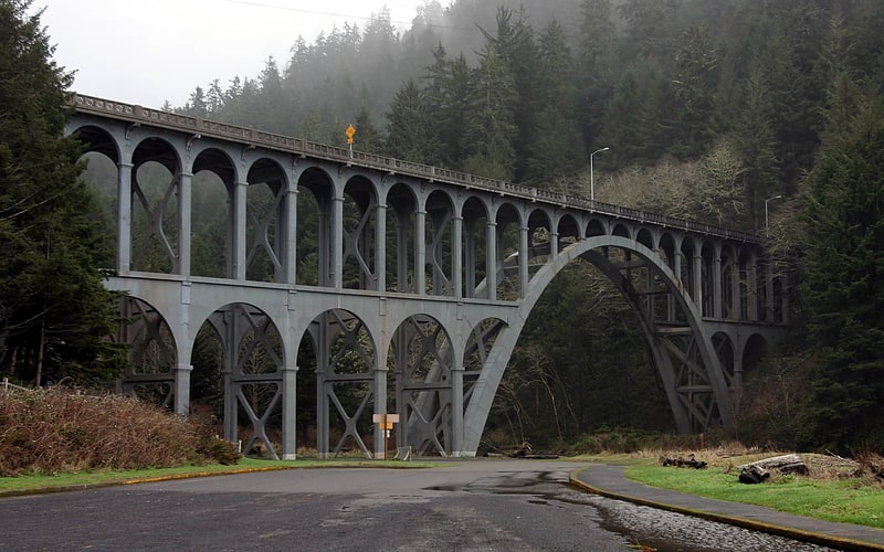
Deck arch bridge in Lane County, Oregon. Cape Creek Bridge is an arch bridge that spans Cape Creek in Lane County, Oregon, United States. The bridge carries U.S. Route 101. Opened in 1932, it was designed by noted bridge engineer Conde McCullough and built of reinforced concrete by John K. Holt. The total length of the bridge is 619 feet, with a main span of 220 feet. The bridge resembles a Roman aqueduct, with a single parabolic arch that spans half its length. It was listed as Cape Creek Bridge No. 01113 on the National Register of Historic Places in 2005, as part of the McCullough, C.B. Major Oregon Coast Highway Bridges MPS.[1]
Oregon Coast Range
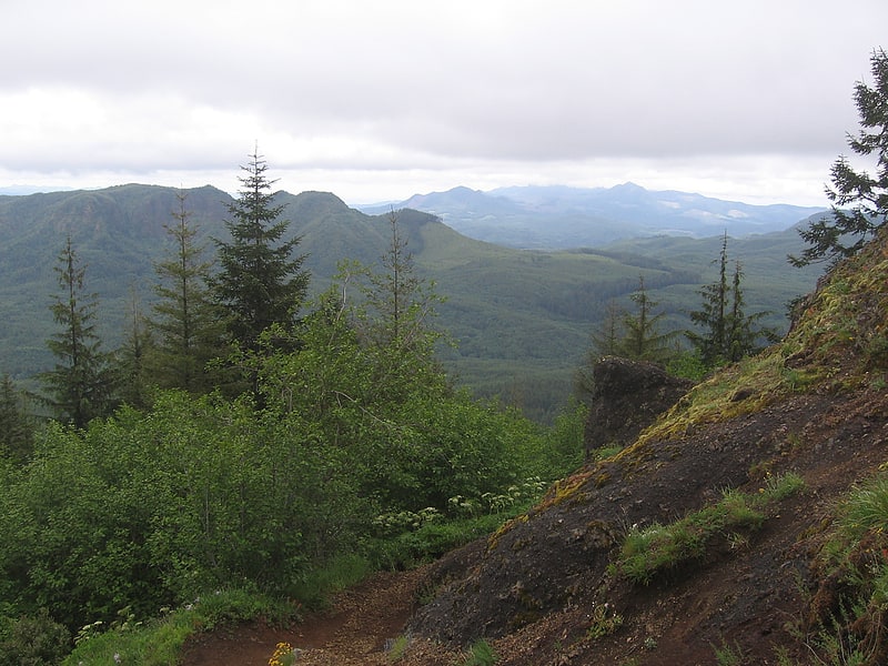
Mountain range in Oregon. The Oregon Coast Range, often called simply the Coast Range and sometimes the Pacific Coast Range, is a mountain range, in the Pacific Coast Ranges physiographic region, in the U.S. state of Oregon along the Pacific Ocean. This north-south running range extends over 200 miles from the Columbia River in the north on the border of Oregon and Washington, south to the middle fork of the Coquille River. It is 30 to 60 miles wide and averages around 1,500 feet in elevation above sea level. The coast range has three main sections, a Northern, Central, and Southern.
The oldest portions of the range are over 60 million years old, with volcanics and a forearc basin as the primary mountain building processes responsible for the range. It is part of the larger grouping known as the Pacific Coast Ranges that extends over much of the western edge of North America from California to Alaska. The range creates a rain shadow effect for the Willamette Valley that lies to the east of the mountains, creating a more stable climate and significantly less rain than the coastal region of the state. To the west where the range over-shadows the Oregon Coast, the range causes more precipitation to fall on that side of the mountains, contributing to the numerous rivers that flow to the Pacific Ocean.
Marys Peak in the Central Coast Range is the highest peak at 4,097 feet (1,248 m). Logging is a major industry in the range in both private and government owned forests. Both the state and federal government manage forests in the Oregon Coast Range. The mountains are home to a variety of wildlife including black bear, elk, deer, beaver, many species of birds, and bats among others. Fish, including salmon and trout, and other aquatic life inhabit the streams and rivers flowing through the range.[2]
Mount Hebo
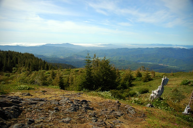
Mountain in Oregon. Mount Hebo is a mountain located on the border of Tillamook County and Yamhill County in the U.S. state of Oregon. Mount Hebo is known for being one of the best, most easily accessed viewpoints in the north Oregon Coast, with a 360-degree view from the summit.
Mount Hebo is part of the Northern Oregon Coast Range and is located in the Siuslaw National Forest overlooking the Pacific Ocean. Access to the summit is provided by an eight-mile forest service road that begins about a quarter mile from the junction of U.S. Route 101 and Oregon Route 22 in the community of Hebo.
Mount Hebo was apparently named by a viewing party seeking a new route to the Willamette Valley that climbed the mountain to get a better view of the terrain. A member of the party said the mountain should be called "Heave Ho" because from their position it looked like it had been heaved up from its surroundings. The name became distorted over the years to its present form.
Mount Hebo was the site of the Mount Hebo Air Force Station, a long-range radar installation, 1956–1980.[3]
Oregon Coast Trail
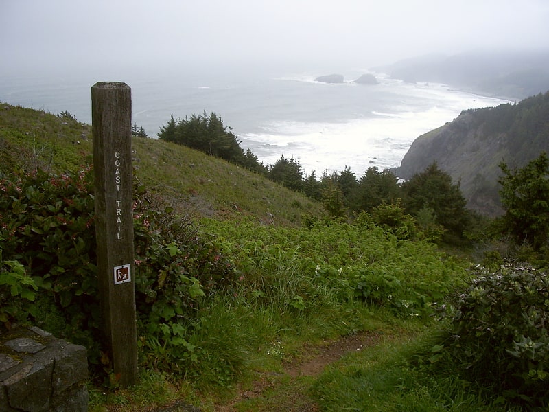
State park. The Oregon Coast Trail is a long-distance hiking route along the Pacific coast of the U.S. state of Oregon in the United States. It follows the coast of Oregon from the mouth of the Columbia River to the California border south of Brookings.
The trail was envisioned in 1959 by Samuel N. Dicken, a University of Oregon geography professor, approved in 1971 by the Oregon Recreation Trails Advisory Council and developed and managed by the Oregon Parks and Recreation Department as part of the state park system of Oregon. The official coastal guide gives a length of 382 miles (615 km). About 39 percent of the route is on the beach, 41 percent is on paved road, and 20 percent is on trail and dirt roads. Private ferries can however be arranged at some estuaries to shortcut road segments. Walked in its entirety, linking each trail/beach section, the distance is approximately 425 miles.
A chief feature of the trail are the public beaches created in 1967 via the Oregon Beach Bill, which formalized the public nature of the coastal beaches since the first such law was passed in 1913. Many of the locations, particularly on the southern portion, are remote and isolated. The Oregon coast is bordered by a temperate rainforest, much of which is now second or third growth.
The difficulty of the trail ranges from easy to moderate, with elevation changes of up to a few hundred feet.[4]