Discover 11 hidden attractions, cool sights, and unusual things to do in Salmon–Challis National Forest (United States). Don't miss out on these must-see attractions: Borah Peak, Merriam Lake, and Leatherman Peak. Also, be sure to include Standhope Peak in your itinerary.
Below, you can find the list of the most amazing places you should visit in Salmon–Challis National Forest (Idaho).
Table of Contents
Borah Peak
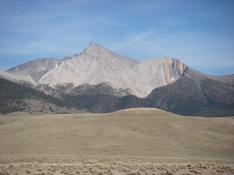
Peak in Idaho. Borah Peak, also known as Mount Borah or Beauty Peak, is the highest mountain in the U.S. state of Idaho and one of the most prominent peaks in the contiguous United States. It is located in the central section of the Lost River Range, within the Challis National Forest in eastern Custer County. On Feb. 11, 2021 the USGS officially recognized Mt. Borah as Idaho's only active glacier.[1]
Merriam Lake
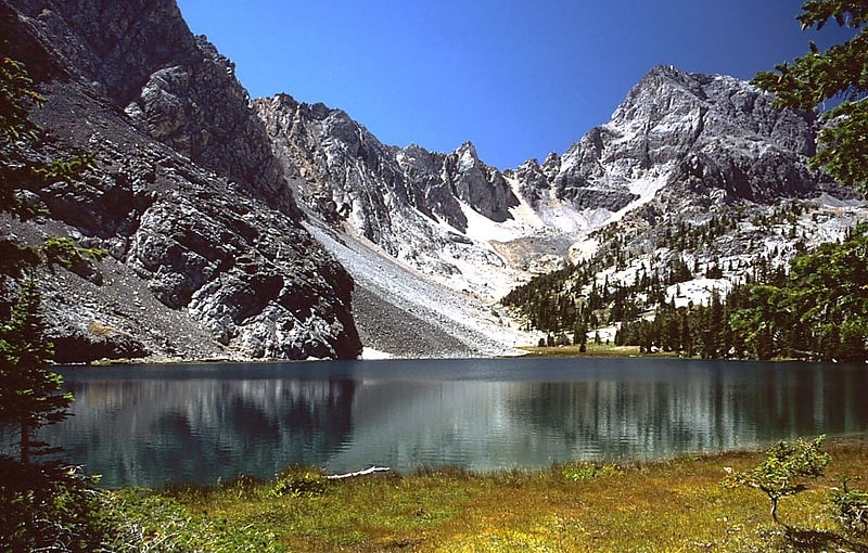
Lake in Idaho. Merriam Lake is a lake situated in the Lost River Range in Idaho, surrounded by mountains over 12,000 ft high. In 2007 the state authorities planted tiger muskies in the lake to better manage the fisheries. Bighorn sheep and Mountain goat are the few mammals disposed to this terrain of central Idaho which Dr. C. Hart Merriam identified as Arctic–alpine when he made a biological survey of the region in 1890.[2]
Leatherman Peak

Peak in Idaho. Leatherman Peak, at 12,228 feet above sea level is the second highest peak in Idaho and the Lost River Range. The peak is located in Salmon-Challis National Forest in Custer County. It is 4.5 mi southeast of Borah Peak, its line parent.[3]
Standhope Peak
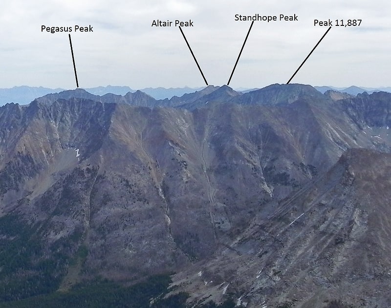
Peak in Idaho. Standhope Peak, at 11,878 feet above sea level is the fourth highest peak in the Pioneer Mountains of Idaho. The peak is located in Salmon-Challis National Forest and Custer County. It is the 20th highest peak in Idaho and about 0.75 mi northeast of Peak 11,887 and 1 mi southwest of Altair Peak.[4]
Old Hyndman Peak
Peak in Idaho. Old Hyndman Peak, at 11,775 feet above sea level is the eighth-highest peak in the Pioneer Mountains of the U.S. state of Idaho. The peak is located on the border of Sawtooth and Salmon-Challis National Forests as well as Blaine and Custer counties. It is the 27th-highest peak in Idaho and about 0.9 mi southeast of Hyndman Peak and 0.8 mi northeast of Cobb Peak.[5]
Mount Breitenbach

Peak in Idaho. Mount Breitenbach, at 12,140 feet above sea level, is the fifth-highest peak in the U.S. state of Idaho and the fourth-highest in the Lost River Range. The peak is located in Salmon-Challis National Forest in Custer County. It is 2.0 miles east of Mount Church, its line parent, 1.4 miles east of Donaldson Peak, 0.85 miles southeast of No Regret Peak, and 1.8 miles north of Lost River Peak.[6]
Donaldson Peak

Peak in Idaho. Donaldson Peak, at 12,023 feet above sea level is the eighth-highest peak in the U.S. state of Idaho and the seventh-highest in the Lost River Range. The peak is located in Salmon-Challis National Forest in Custer County. It is 0.65 miles east of Mount Church, its line parent and 1.4 miles west of Mount Breitenbach.[7]
Kent Peak
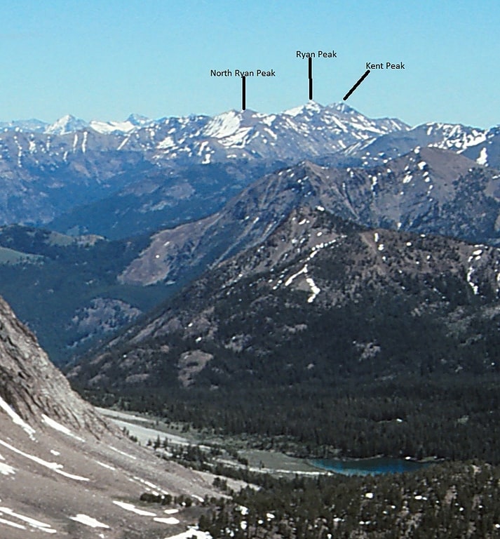
Peak in Idaho. Kent Peak, at 11,664 feet above sea level is the second highest peak in the Boulder Mountains of Idaho. Located on the border of Blaine and Custer counties, Kent Peak is about 0.75 miles south of the range's highest point, Ryan Peak. The peak is also on the border of Sawtooth National Recreation Area and Salmon-Challis National Forest and partially within the Hemingway–Boulders Wilderness. It is the 34th highest peak in Idaho.
The primary route to Kent Peak begins north of Ketchum along Idaho State Highway 75 at the Sawtooth National Recreation Area headquarters. Take national forest road 146 north from the headquarters until you reach the trailhead at the end of the road. Trail 115 ascends the ridge to the west of Kent Peak, but the primary class 3 route follows the south ridge.[8]
Mount Church
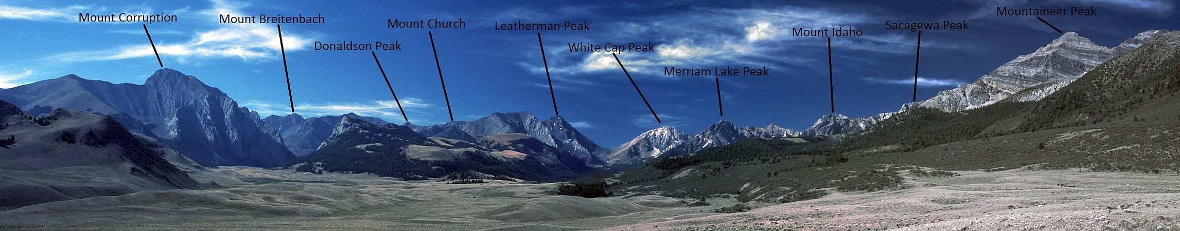
Peak in Idaho. Mount Church, at 12,200 feet above sea level is the third highest peak in Idaho and the Lost River Range. The peak is located in Salmon-Challis National Forest in Custer County. It is 1.45 mi southeast of Leatherman Peak, its line parent, and 0.65 mi northwest of Donaldson Peak. The peak has not been officially named or measured, but it has been unofficially named after Frank Church, a former Senator from Idaho.[9]
Goldbug Hot Springs
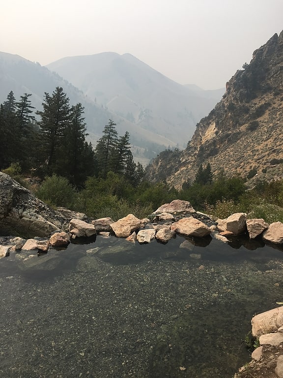
Nature preserve in Lemhi County, Idaho. Goldbug Hot Springs is a hot spring located in the Salmon-Challis National Forest about 20 miles south of Salmon, Idaho. The spring is along Warm Spring Creek and there are about six waterfall-fed pools. Goldbug is listed as having a temperature of 113 °F, but the temperature of the pools will vary depending on the time of year. The pools have a sand/gravel bottom and are dammed by boulders. Due to the hike and remoteness of the trailhead, it is not usually crowded.
Water from Goldbug Hot Springs flows into Warm Springs Creek, which flows into the Salmon River.[10]
Lemhi Pass
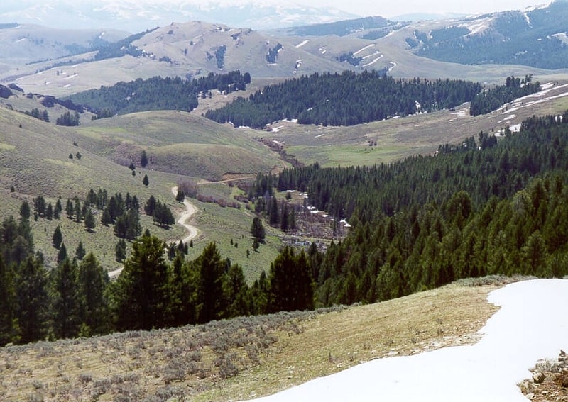
Mountain pass in Idaho. Lemhi Pass is a high mountain pass in the Beaverhead Mountains, part of the Bitterroot Range in the Rocky Mountains and within Salmon-Challis National Forest. The pass lies on the Montana-Idaho border on the continental divide, at an elevation of 7,373 feet above sea level. It is accessed via Lemhi Pass Road in Montana, and the Lewis and Clark Highway in Idaho, both dirt roads. Warm Springs Road, which roughly follows the divide in Montana, passes just west of the pass's high point.[11]