Discover 15 hidden attractions, cool sights, and unusual things to do in Roosevelt National Forest (United States). Don't miss out on these must-see attractions: Chapel on the Rock, Poudre Canyon, and Horsetooth Mountain. Also, be sure to include Comanche Reservoir in your itinerary.
Below, you can find the list of the most amazing places you should visit in Roosevelt National Forest (Colorado).
Table of Contents
Chapel on the Rock
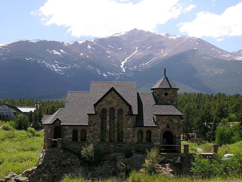
Church in Allenspark, Colorado. The Chapel on the Rock is a functioning Catholic chapel and tourist landmark in Allenspark, Colorado, USA. The chapel is located on the grounds of the Saint Malo Retreat, Conference, and Spiritual Center of the Catholic Archdiocese of Denver. The chapel is open to the public.[1]
Address: 10758 State Highway 7, 80510-9615 Allenspark
Poudre Canyon
The Poudre Canyon is a narrow verdant canyon, approximately 40 mi long, on the upper Cache la Poudre River in Larimer County, Colorado in the United States. The canyon is a glacier-formed valley through the foothills of the Front Range of the Rocky Mountains northwest of Fort Collins.[2]
Horsetooth Mountain
Mountain in Colorado. Horsetooth Mountain is a mountain summit in the foothills of the Front Range of the Rocky Mountains of North America. The 7,259-foot peak is located in the Horsetooth Mountain Open Space, 7.0 miles west of downtown Fort Collins in Larimer County, Colorado, United States.[3]
Comanche Reservoir
Reservoir in Colorado. Comanche Reservoir is a large reservoir in the Comanche Peak Wilderness in the Roosevelt National Forest within Colorado, United States. It lies on several hiking trails and is close to the Pingree Park wilderness campus of Colorado State University.
This body of water is not to be confused with Comanche Lake, which is shortly to the reservoir's west.[4]
The Great Stupa of Dharmakaya
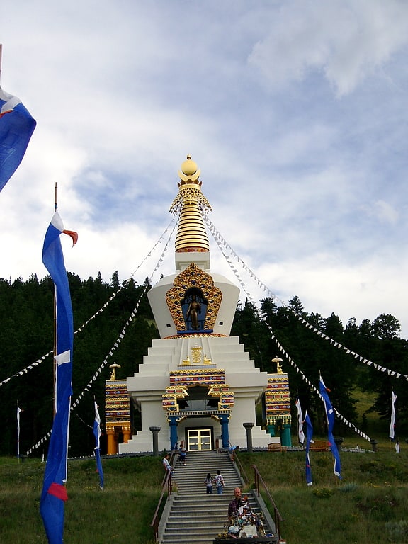
Monument in the Larimer County, Colorado. The Great Stupa of Dharmakaya Which Liberates Upon Seeing is located at the Shambhala Mountain Center in Colorado, USA. It was built to inter the ashes of Chogyam Trungpa, who died in 1987. In many Buddhist traditions it is common to build a stupa to honour a respected teacher after their death. The site of the Great Stupa of Dharmakaya was first identified as an auspicious location by the 16th Karmapa, head of the Kagyü school of Tibetan Buddhism, on his first visit to North America in 1974.
Construction of the stupa began in 1988. The structure took thirteen years to complete and used a special concrete formula designed to last one thousand years. The Stupa was consecrated in a ceremony that lasted several days in the summer of 2001. This ceremony was attended by many important lamas and students of Chogyam Trungpa.
In September 2006, The Dalai Lama visited the Great Stupa for the first time.[5]
Address: 151 Shambhala Way, Roosevelt National Forest
North Arapaho Peak
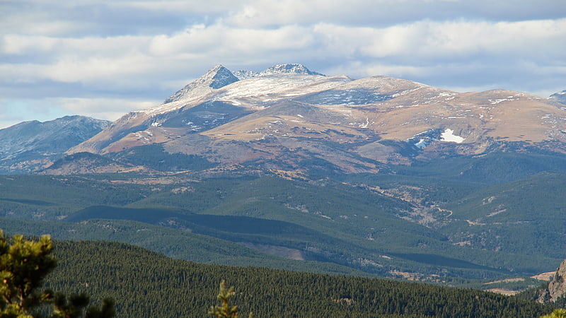
Summit in Colorado. North Arapaho Peak is the highest summit of the Indian Peaks in the northern Front Range of the Rocky Mountains of North America. The 13,508-foot thirteener is located in the Indian Peaks Wilderness, 7.8 miles west-southwest of the Town of Ward, Colorado, United States, on the Continental Divide separating Roosevelt National Forest and Boulder County from Arapaho National Forest and Grand County.
Between North Arapaho Peak and neighboring South Arapaho Peak sits Arapaho Glacier, which is owned by the City of Boulder as part of its water supply. North and South Arapahoe Peaks are connected by a 0.8 mile, Class 4 connecting ridge. West of these peaks is Arapaho Pass.[6]
Viestenz-Smith Mountain Park
Park, Relax in park
Address: 1211 Big Thompson Canyon Rd, Roosevelt National Forest
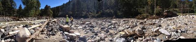
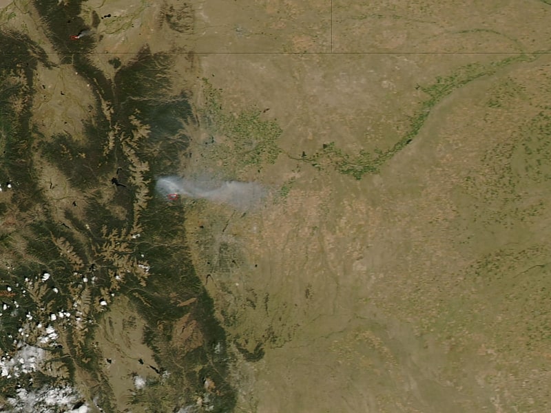
Fourmile Canyon
Fourmile Canyon or Four Mile Canyon is a mountainous canyon in western Boulder County, Colorado that channels a stream known as Fourmile Creek or Four Mile Creek.). The stream rises at 40.048°N 105.550°W / 40.048; -105.550 on the southern slope of Niwot Mountain, before flowing east and south through the unincorporated communities of Sunset, Wallstreet, Salina and Crisman to the confluence with Boulder Creek at 40.015°N 105.324°W / 40.015; -105.324 in Boulder Canyon, four miles west of the historic location of the Boulder Railroad Depot.
The canyon and surrounding area were the site of an eponymous major wildfire in September 2010.[7]
Big Thompson River bridges
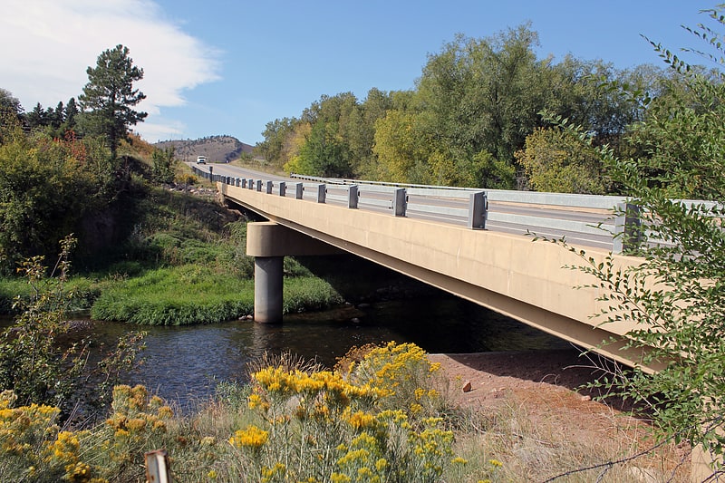
Four historic bridges on the Big Thompson River in Larimer County, Colorado survived its flood of 1976, but since have lost most of their historic integrity. They were built in 1933 and 1937. All four were listed on the National Register of Historic Places in 2002, and two were delisted in 2010.
The four bridges:
- Big Thompson River Bridge I, US 34 at milepost 65.53, Estes Park, CO
- Big Thompson River Bridge II, US 34 at milepost 66.22, Estes Park, CO
- Big Thompson River Bridge III, US 34 at milepost 85.15, Loveland, CO
- Big Thompson River Bridge IV, US 34 at milepost 86.04, Loveland, CO
All four were camelback pony truss bridges that were designed by the Colorado Department of Highways and fabricated by Midwest Steel & Iron Works. Bridges III and IV were put together by Lawrence Construction Company in 1933, and bridges I and II were put together by contractor M.E. Carlson four years later.
The bridges were deemed significant for representing transportation and for their preserved structure. Bridges I and II were removed from the National Register on November 29, 2010. Delistings from the NRHP usually occur when a listed building or other structure is demolished or if its historic integrity is otherwise severely compromised. Bridges III and IV have been substantially renovated in place so far that their camelback truss structures are entirely gone, but they currently remain on the Register.
The four bridges were identified as conforming to terms defined for historic bridge notability as defined in a 2000 study.[8]
Shambhala Mountain Center
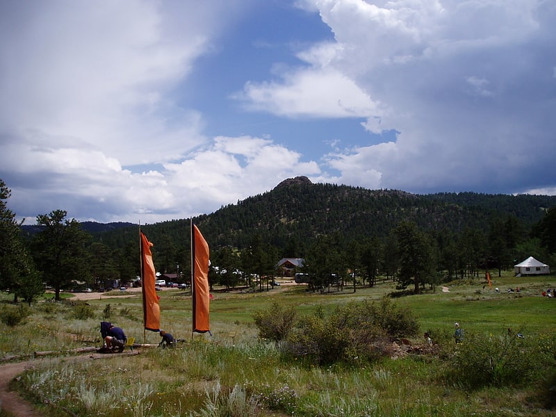
Non-profit organization in the Larimer County, Colorado. The Shambhala Mountain Center was founded by Chögyam Trungpa Rinpoche in 1971 at Red Feather Lakes, Colorado. Shambhala Mountain Center is located on 600 acres in a valley in the northern Colorado Rockies.
Shambhala Mountain Center was previously known as Rocky Mountain Dharma Center (RMDC) and Rocky Mountain Shambhala Center. The center is one of several retreat centers affiliated with Shambhala International, a global new religious movement that has been in crisis in recent years due to multiple credible allegations of sexual misconduct against its leader, and public revelations of an institutional history of ongoing abuse.[9]
Address: 151 Shambhala Way, Roosevelt National Forest
Arapaho Glacier
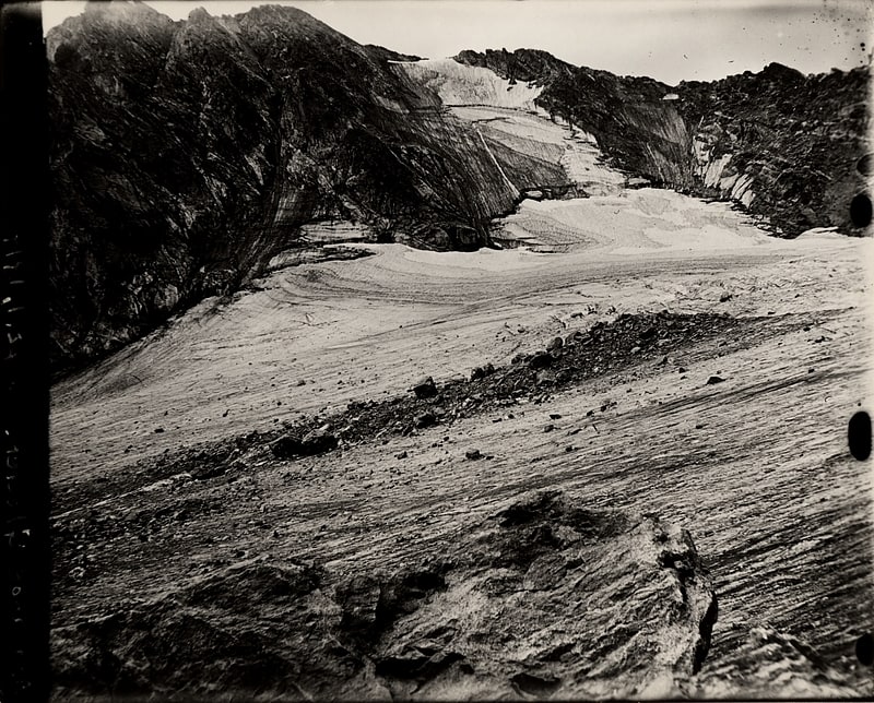
Arapaho Glacier is an alpine glacier in a cirque immediately southeast of North Arapaho Peak, in Roosevelt National Forest in the U.S. state of Colorado. The glacier is just east of the Continental Divide. Arapaho Glacier is the largest glacier in the state of Colorado and helps provide water for the city of Boulder, Colorado. The glacier has a negative glacier mass balance and lost over 52% of its surface area during the 20th Century.[10]
Rollins Pass
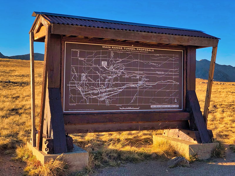
Mountain pass in Colorado. Rollins Pass, elevation 11,676 ft, is a mountain pass and active archaeological site in the Southern Rocky Mountains of north-central Colorado in the United States. The pass is located on and traverses the Continental Divide of the Americas at the crest of the Front Range southwest of Boulder and is located approximately five miles east and opposite the resort in Winter Park—in the general area between Winter Park and Rollinsville. Rollins Pass is at the boundaries of Boulder, Gilpin, and Grand counties. Over the past 10,000 years, the pass provided a route over the Continental Divide between the Atlantic Ocean watershed of South Boulder Creek with the Pacific Ocean watershed of the Fraser River, a tributary of the Colorado River.
The abandoned rail route over Rollins Pass was nominated for and accepted into the National Register of Historic Places in 1980 because of significant events and engineering feats accomplished by railroading efforts in the early 20th century. In 1997, additional areas on the pass were added to the National Register of Historic Places to include achievements made by John Q.A. Rollins and his toll wagon road that traversed the pass.
In 2012, Rollins Pass was listed as one of the most endangered sites in Colorado.[11]
Wall Street Assay Office
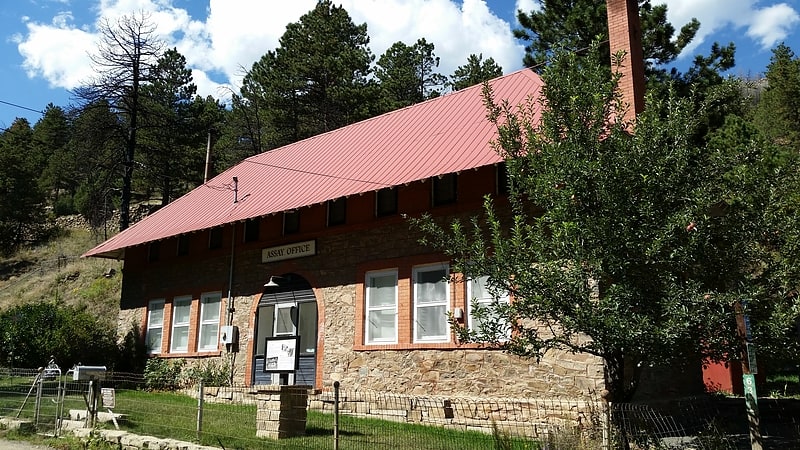
Museum in Boulder County, Colorado. The Wall Street Assay Office is a historic commercial building related to precious metal mining in the western outskirts of Boulder, Colorado in an area known as Wall Street. Once a thriving mining town in Boulder County's foothills area, Wall Street is now home to a few dozen residential properties scattered among the remnants of the Storm King mine. The Wall Street Assay Office sits on Four Mile Canyon Dr, now preserved as the James F. Bailey Assay Office Museum.
The Wall Street area was home to a variety of metal mining activities in the late 1800s, including a small camp named Delphi. Charles Caryl visited the area in 1889, returned east to raise money, and opened the Gold Extraction Mining and Supply Company in present-day Wall Street in 1897. The Assay Office was constructed along with a store and boarding house, a large mill was built in 1901. The operation failed two years later. The assay office was purchased at a sheriff's sale by James Bailey in 1907. It was used as the office of the Storm King Mine, and later converted into a residence for the Bailey family.[12]
Nokhu Crags
Rock formation in Colorado. Nokhu Crags is a rock formation and mountain summit in the Never Summer Mountains range of the Rocky Mountains of North America. The name is derived from the Arapaho language, Neaha-no-xhu, meaning "Eagles Nest." The 12,490-foot peak is located in State Forest State Park, 2.5 miles south of Cameron Pass in Jackson County, Colorado, United States. The summit lies just northwest of the Continental Divide and Rocky Mountain National Park, near the headwaters of the Michigan River. The peak is prominently visible from State Highway 14 and can be seen throughout the southern North Park basin where it is known also known as "the Crags" or "Sleeping Indian" for its resemblance to the form of a supine chief. To the east lie the shallow basins of Snow Lake and the Michigan or American Lakes; to the north lies a snow filled couloir; to the west the mountain descends directly into the deep waters of Lake Agnes; and to the south lie Static Peak, Mount Richthofen, and the remainder of the Never Summer Mountain Range.[13]
Left Hand Creek
Tributary in Colorado. Left Hand Creek is a tributary of Saint Vrain Creek, approximately 33.9 miles long, in Boulder County, Colorado in the United States. The creek drains a section of the foothills of the Front Range northwest of Boulder, descending from the mountains in a steep canyon, known as Left Hand Canyon. Left Hand Creek issues from Left Hand Park Reservoir along the north flank of Niwot Mountain. Flowing through a steep gorge to the East, passing below Ward. It emerges from the foothills North of Boulder and crosses ranch lands the Colorado Piedmont, passing north of Niwot and joining St. Vrain Creek on the South edge of Longmont.
Lower Left Hand canyon is a popular destination for road biking, hiking, whitewater kayaking and rock climbing. It contains several City of Boulder Open Space parks along the Boulder County road that ascends into the canyon from U.S. Highway 36 north of Boulder. The canyon rims provide habitat for raptors and are seasonally closed to rock climbing during the late winter and early spring during nesting season.
The creek was named for Chief Left Hand of the Arapaho Indians. In 1859, during the Colorado Gold Rush, the canyon was the site of an early discovery of gold at Gold Hill located on a side gully approximately halfway up the canyon.
Left Hand Creek experienced a significant flood event in September 2013. This flood killed one resident of Jamestown in a debris flow from an adjacent ravine in the town. The flood of September 2013 considerably redistributed stream sediment and re-channelized the stream bed in places. Mitigation and recovery efforts in the town of Jamestown and for all Left Hand canyon residents is ongoing in 2017. Lefthand Watershed Oversight Group, a nonprofit watershed organization based in Boulder County, works to assess, protect, and restore the quality of the Left Hand Creek Watershed.
An obscure whitewater kayak run until 2000, Left Hand Canyon was first run in 1998 by Brook Aitken, Chris McEniry, and Craig D. Irwin. The whitewater kayakers first descended the Class V mini-gorge by entering through a small culvert passing under Left Hand Canyon Drive and beginning a tight and snaking boulder garden entrance through a cascade along the road. The mini gorge is below the roadway of Left Hand Canyon and is frequently choked with woody debris. The Left Hand Creek kayak run is short and full of action.
The City of Boulder Mountain Parks and Open Space has one parking facility at Buckingham Park.[14]