Discover 7 hidden attractions, cool sights, and unusual things to do in Point Reyes National Seashore (United States). Don't miss out on these must-see attractions: Point Reyes Lighthouse, Kule Loklo, and Abbotts Lagoon. Also, be sure to include Point Reyes Lifeboat Station in your itinerary.
Below, you can find the list of the most amazing places you should visit in Point Reyes National Seashore (California).
Table of Contents
Point Reyes Lighthouse
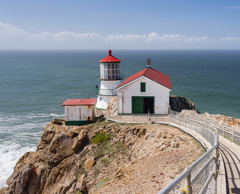
Historic lighthouse with museum . The Point Reyes Lighthouse, also known as Point Reyes Light or the Point Reyes Light Station, is a lighthouse in the Gulf of the Farallones on Point Reyes in Point Reyes National Seashore, located in Marin County, California, United States.
The park's adjacent Lighthouse Visitor Center features exhibits about the lighthouse and the park's marine life and natural history. Visitors can climb about 300 steps down to the lighthouse itself, weather permitting. The main chamber of the lighthouse, known as the Lens Room, features the Fresnel lens and clockwork mechanism, and is open to the public on a limited basis.[1]
Address: 1 Bear Valley Rd, 94956-9740 Point Reyes National Seashore
Kule Loklo
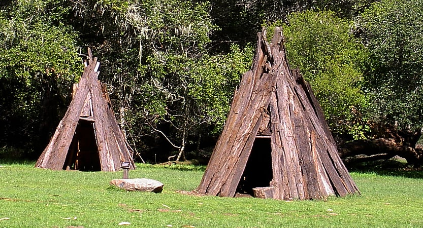
Historical landmark in Marin County, California. Kule Loklo is a recreated Coast Miwok Native American village located a short walk from the visitor center of the Point Reyes National Seashore, in Marin County, California. Kule Loklo was originally created in the 1970s by the Miwok Archeological Preserve of Marin as a tribute to Marin County's indigenous people, the Coast Miwoks.
In 1992, the ceremonial roundhouse at Kule Loklo was destroyed by an arsonist; through an outpouring of community support, it was replaced with a larger roundhouse in 1993.
There is currently one annual public festival at Kule Loklo, the Big Time, held in late July, which features California Indian dancing and Native American crafts.[2]
Abbotts Lagoon
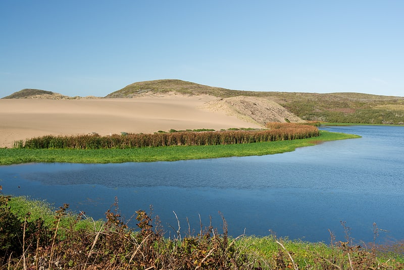
Lagoon in California. Abbotts Lagoon is a two-stage lagoon on the northwestern coast of the Point Reyes National Seashore, southwest of Tomales Point, in California, United States. The upper lagoon is a fresh water impoundment which overflows into a lower brackish level with occasional winter tidal exchange. The eastern shore of the lagoon is covered with old growth northern coastal scrub including coyote bush, yellow bush lupine, sword fern and California blackberry.[3]
Address: Abbotts Lagoon Trail, Point Reyes National Seashore
Point Reyes Lifeboat Station
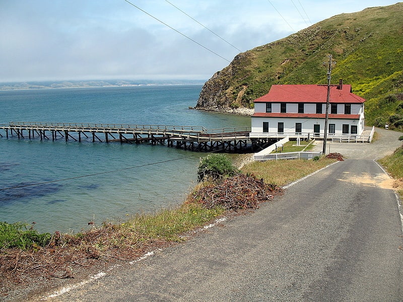
Point Reyes Lifeboat Station, also known as Point Reyes Lifeboat Rescue Station, is a historic coastal rescue station, located on the Drake's Bay side of Point Reyes in northern California, United States. It was built in 1927 by the United States Lifesaving Service to replace a previous station dating from 1888. It is one of the best-preserved rescue stations of that period on the Pacific coast, retaining elements often lost, including the boat launching infrastructure. It is now a historic property managed by the National Park Service as part of Point Reyes National Seashore. It was listed on the National Register of Historic Places in 1985, and it was further declared a National Historic Landmark in 1989.[4]
Bird Rock
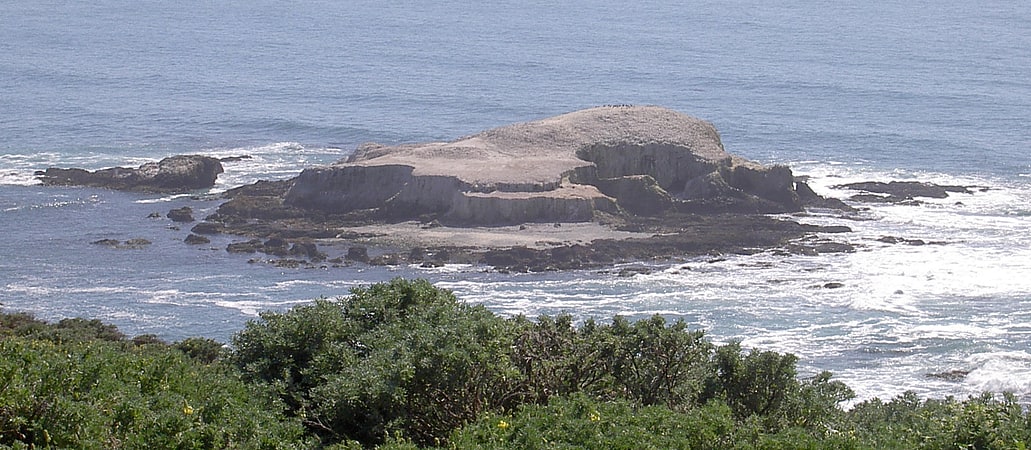
Island in Marin County, California. Bird Rock is a rock formation and a small Pacific island west of Tomales Point in Marin County, California that is roughly 2 acres.
A seabird colony, the island is covered with a layer of guano. Cormorants are common on the island, and ashy petrels were found breeding there in 1972.[5]
Tomales Bay
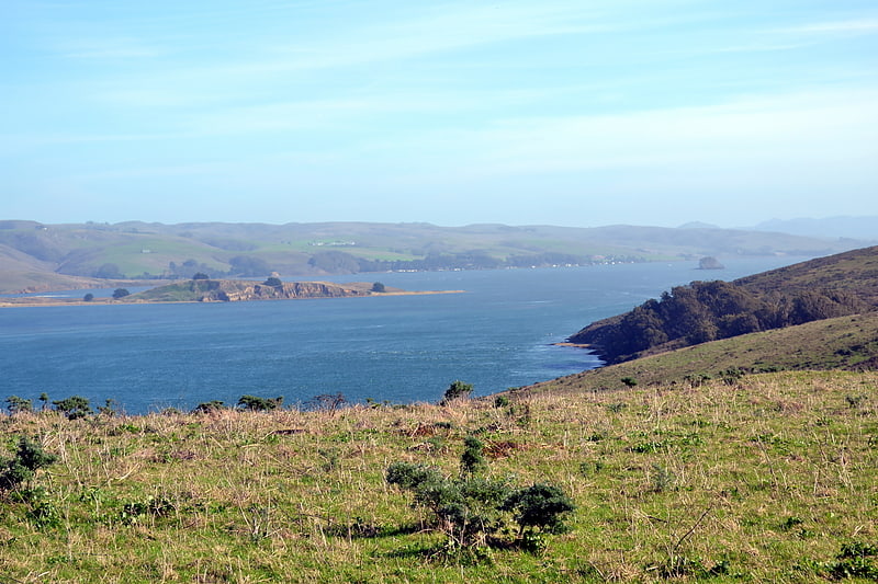
Inlet in California. Tomales Bay is a long, narrow inlet of the Pacific Ocean in Marin County in northern California in the United States. It is approximately 15 mi long and averages nearly 1.0 mi wide, effectively separating the Point Reyes Peninsula from the mainland of Marin County. It is located approximately 30 mi northwest of San Francisco. The bay forms the eastern boundary of Point Reyes National Seashore. Tomales Bay is recognized for protection by the California Bays and Estuaries Policy. On its northern end, it opens out onto Bodega Bay, which shelters it from the direct current of the Pacific. The bay is formed along a submerged portion of the San Andreas Fault.
Oyster farming is a major industry on the bay. The two largest producers are Hog Island Oyster Company and Tomales Bay Oyster Company, both of which retail oysters to the public and have picnic grounds on the east shore. Hillsides east of Tomales Bay are grazed by cows belonging to local dairies. There is also grazing land west of the bay, on farms and ranches leased from Point Reyes National Seashore.
The bay sees significant amounts of water sports including sailing, kayaking, fishing and motor boating. Watercraft may be launched on Tomales Bay from the public boat ramp at Nick's Cove, north of Marshall. The sand bar at the mouth of Tomales Bay is notoriously dangerous, with a long history of small-boat accidents.
The California Office of Environmental Health Hazard Assessment (OEHHA) has developed a safe eating advisory for fish caught here, based on levels of mercury or PCBs found in local species.
Towns bordering Tomales Bay include Inverness, Inverness Park, Point Reyes Station, and Marshall. Additional hamlets include Nick's Cove, Spengers, Duck Cove, Shallow Beach, and Vilicichs. Dillon Beach lies just to the north of the mouth of the bay, and Tomales just to the east.[6]
Olema Lime Kilns
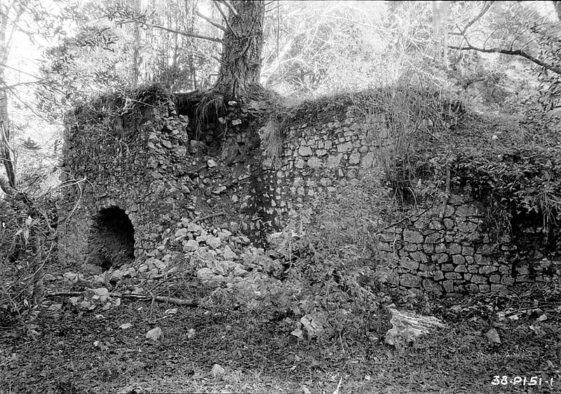
Historical landmark in Marin County, California. The Olema Lime Kilns at Point Reyes National Seashore in California were built in 1850 on land leased from Mexican grantee Rafael Garcia by James A. Shorb and William F. Mercer, two San Francisco entrepreneurs. The kilns were reportedly fired only a few times, and have lain abandoned for some 140 years. They were apparently abandoned no later than 1855 after only a few firings, probably due to the poor quality, small limestone deposits and the financial depression of that year. They represent a Gold Rush era effort to establish a lime-producing industry in Marin County, only two years after cession of Alta California to the United States by Mexico. They consist of three long-abandoned, barrel-shaped stone vaults lying in ruins against a hillside on the east side of Olema Creek about five miles south of Olema and about 100 yards west of California State Highway 1.[7]