Discover 11 hidden attractions, cool sights, and unusual things to do in Okinawa Island (Japan). Don't miss out on these must-see attractions: Nakagusuku Castle, Sefa-utaki, and Hiji Falls. Also, be sure to include Mount Yonaha in your itinerary.
Below, you can find the list of the most amazing places you should visit in Okinawa Island (Okinawa).
Table of Contents
Nakagusuku Castle
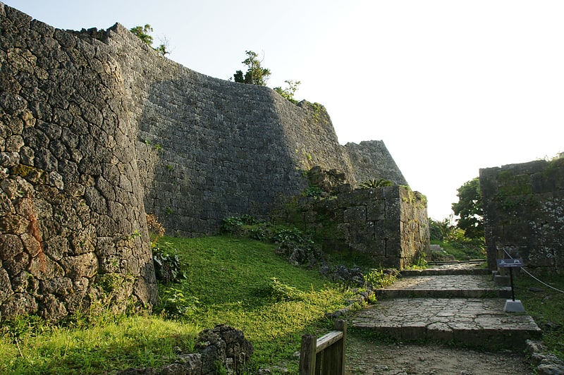
Also known as: 中城城
UNESCO-listed 14th-century castle ruins. Nakagusuku Castle is a gusuku in the village of Kitanakagusuku, Okinawa, Japan. It is one of a number of castles built on the island of Okinawa by the Ryukyu Kingdom now in ruins. The legendary Ryukyuan commander, Gosamaru, built the fortress in the early 15th century to defend against attacks from the east by Lord Amawari of Katsuren Castle. Amawari attacked the castle in 1458 and defeated Gosamaru shortly before his own castle was attacked by Uni-Ufugusuku. The castle was visited by Commodore Matthew C. Perry in 1853, who noted that the walls seemed to be designed to absorb cannon fire. The six courtyards of this fortress with stacked stone walls make it a prime example of a gusuku. It was added to the list of UNESCO World Heritage Sites in 2000. It is regarded as one of the 100 most famous castles in Japan. Less than 50 metres away from the castle is the Nakagusuku Hotel ruins.[1]
Address: 503 Ogusuku, 901-2314 Okinawa Island
Sefa-utaki
Also known as: 斎場御嶽
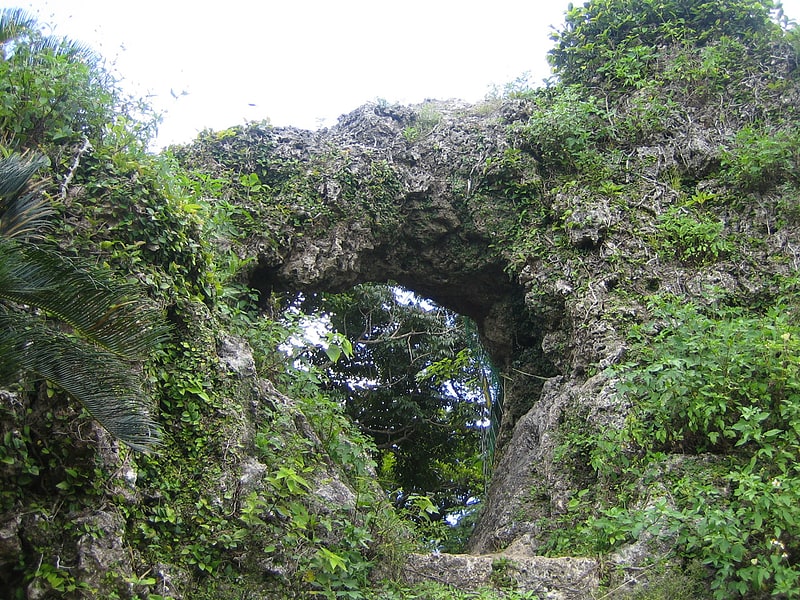
Place of worship in Nanjo, Japan. Sefa-utaki, meaning "purified place of Utaki," is a historical sacred space, overlooking Kudaka Island, that served as one of the key locations of worship in the native religion of the Ryukyuan people for millennia. Later as a part of assimilation of Okinawa by Japan, it was shifted to serve as a Shinto Shrine. It is part of the UNESCO World Heritage Site Gusuku Sites and Related Properties of the Kingdom of Ryukyu in Nanjō, Okinawa.
Sefa Utaki is on the Chinen Peninsula, and has been recognized as a sacred place since the earliest period of Ryukyuan history. According to Chūzan Seikan, this was the spot where Amamikyu, goddess of creation, made landfall on Okinawa. The shrine area itself comprises a number of caves and overhanging ledges opening to the east and south among towering rock formations of a high promontory over the sea. All buildings have been destroyed, but the outer and inner precincts can still be traced.[2]
Address: 知念久手堅 Nanjo, Okinawa Island
Hiji Falls
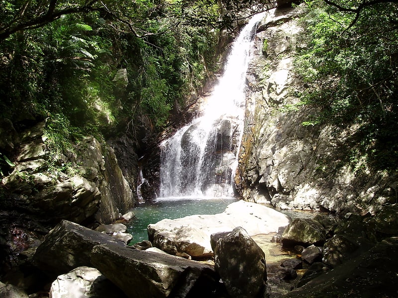
Hiji Falls is a National Park and a popular tourist destination on the island and prefecture of Okinawa, Japan. It is located in the northern part of the Okinawa Island, approximately 20 kilometers north of the city of Nago and close to the Yambaru National Park. The falls and the ensuing river flow region tropical most of the year. It is a popular destination for both sightseers and hikers. From start to the finish, the finished trail is about 2 miles, with many steep stairs throughout the path. Camping is permitted with various camp sites. People visiting the area are warned not to swim near the falls because there have been two deaths since 2013 and various falls.[3]
Mount Yonaha
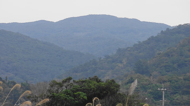
Also known as: 与那覇岳
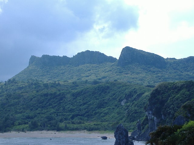
Mountain in Japan. Mount Yonaha, also known as Mount Yunaha in Okinawan, is a mountain in Kunigami on the main island of Okinawa in Okinawa Prefecture. It has an elevation of 503 m, but Yonaha-dake triangulation station is located at the next peak of elevation of 498 m.[4]
Tamagusuku Castle
Also known as: 玉城城
Tamagusuku Castle is a Ryukyuan gusuku in Nanjō, Okinawa. It is the oldest castle on Okinawa; Chūzan Seikan says it was built by Amamikyu, the creation goddess of the Ryukyuan religion. It was the home of the Aji of Tamagusuku Magiri.
It is located about 700 meters north of Tamagusuku village. The castle is almost a complete ruin and is visited as a sacred grove[5]
Tropical & Subtropical Arboretum
The Tropical & Subtropical Arboretum is a 9-hectare arboretum and botanical garden located in the southern tip of the Ocean Expo Park at Ishikawa 424, Motobu-cho, Kunigami-gun, Okinawa, Japan. It is open daily without charge.
The arboretum was established in August 1976 on the site of the 1975 Okinawa Ocean Expo, and describes itself as the only tropical and subtropical arboretum in Japan with Okinawan climate. Its mission is education and the promotion of the urban afforestation, with sample gardens including nearly 37,500 plants representing 320 species of tropical and subtropical plants. Major arboretum features include an herb garden, hedge & vine area, ground cover area, street trees, and sections for salt and wind tolerant trees, palm trees, and bushes.
There is an aquarium in the botanical garden where rainforest fish such as Arapaima and various species of Arowana, Catfish, and Freshwater Stingray are bred.[6]
Omoro Botanical Garden

Museum in Motobu, Japan. The Omoro Botanical Garden, also known as the Omoro Arboretum, is an arboretum and botanical garden located in the Ocean Expo Park, 424 Ishikawa, Motobu, Okinawa, Japan. It is open daily except Thursdays; admission is free.
This facility was opened in 1980 to commemorate the Okinawa International Ocean Exposition. At a 2003 press conference, Emperor Akihito suggested the garden serve as a parallel to Japan's Manyo botanical gardens, which feature plants appearing in the Man'yōshū anthology (much like a Shakespeare garden in the English-speaking world). Accordingly, this garden collects plants that are described in the Omoro Sōshi (おもろそうし), a collection of Okinawan poems and songs.
The garden contains about 400 species of salt-resistant plants organized into zones, including large trees (Ficus microcarpa, Ficus superba, Ficus virgata, Bischofia javanica, etc.), small trees (Maytenus diversifolia, Scaevola taccada, Wikstroemia retusa), shade trees (Artocarpus altilis, Ficus lyrata, Koelreuteria elegans subsp. formosana), and other plants including Antidesma pentandrum, Buxus liukiuensis (Makino), Clerodendrum inerme, and Murraya paniculata, as well as various garden plants, herbs, and so forth.
The garden also contains more than 110 wild orchid species, many of them endangered, native to the Ryukyu Islands. These include Acanthephippium pictum, Acanthephippium sylhetense, Bulbophyllum macraei, Dendrobium okinawense, Eria ovata, Eulophia graminea, Gastrochilus japonicus, Gerdorum densiflorum, Malaxis kandae, Neofinetia falcata, Sedirea japonica, and Tainia laxiflora.[7]
Kanna Dam
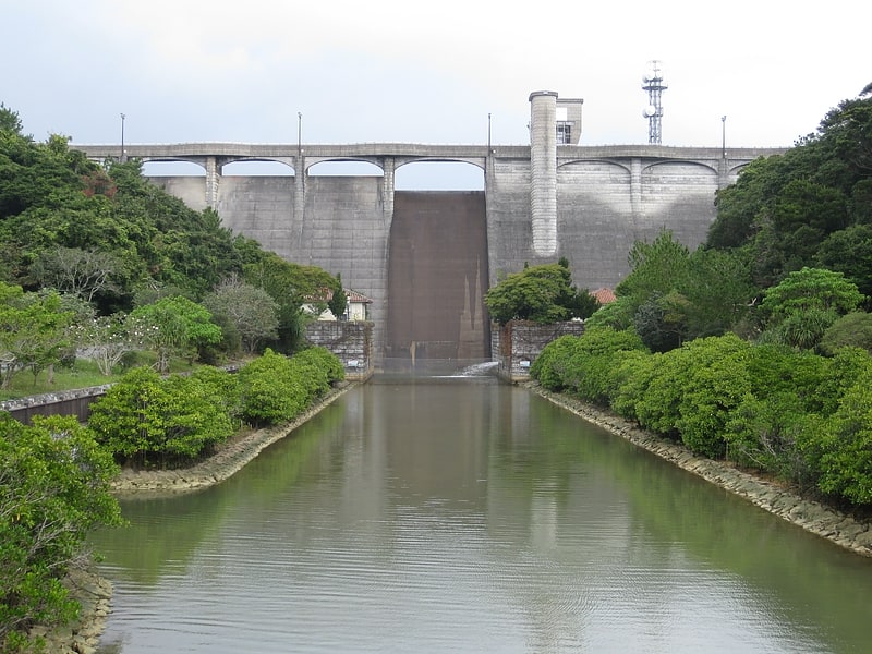
Also known as: 漢那ダム
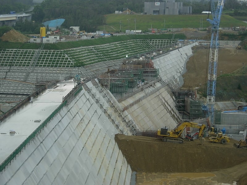
Park in Ginoza, Okinawa, Japan. The Kanna Dam is a concrete gravity dam on the Kanna River in Ginoza, Okinawa Prefecture, Japan. The purpose of the dam is water supply and flood control. After studies were carried out in the 1970s, construction on the dam began in 1982 and it was completed in 1992. The dam is 45 m tall and 185 m long. In order to retain the reservoir, a 37 m tall and 500 m long saddle dam was constructed directly northeast of the dam. A fish ladder was installed on the dam during construction to assist the migration of fish, shrimp and crabs. Mangroves downstream of the dam were restored after construction and the area is a tourist destination along with a habitat for water fowl.[8]
Ryukyu Islands
Also known as: 琉球諸島
Island chain in Japan. The Ryukyu Islands are, depending on definitions, the whole or part of a chain of Japanese islands that stretch southwest from Kyushu to Taiwan. According to the standardized geographical names of Japan, the Nansei Islands cover the entire island chain: the Ōsumi, Tokara, Amami, Okinawa, Sakishima Islands, the Senkaku Islands, and the Daitō Islands, with Yonaguni the westernmost. According to the standard, the Ryūkyū Shotō consist of the Okinawa, Sakishima and Senkaku Islands. A related term, the Ryukyu Arc, often excludes the outlying islands of Senkakus and Daitōs. The larger are mostly high islands and the smaller mostly coral. The largest is Okinawa Island.
The island chain is not a coherent entity. The climate of the islands ranges from humid subtropical climate (Köppen climate classification Cfa) in the north to tropical rainforest climate (Köppen climate classification Af) in the south. Precipitation is very high and is affected by the rainy season and typhoons. Except the outlying Daitō Islands, the island chain has two major geologic boundaries, the Tokara Strait (between the Tokara and Amami Islands) and the Kerama Gap (between the Okinawa and Miyako Islands). The islands beyond the Tokara Strait are characterized by their coral reefs.
The Ōsumi and Tokara Islands, the northernmost of the islands, fall under the cultural sphere of the Kyushu region of Japan; the people are ethnolinguistically mainland Japanese and speak a variation of the Kagoshima dialect of Japanese. The Amami, Okinawa, Miyako, and Yaeyama Islands have native populations collectively called the Ryukyuan people. The highly diversified Ryukyuan languages are traditionally spoken on these islands. In modern times, the Japanese language is the primary language of the islands, with the Okinawan Japanese dialect prevalently spoken. The outlying Daitō Islands were uninhabited until the Meiji period, when their development was started mainly by people from the Izu Islands south of Tokyo, with the people there speaking the Hachijō language.
Administratively, the islands are divided into Kagoshima Prefecture (specifically the islands administered by Kagoshima District, Kumage Subprefecture/District, and Ōshima Subprefecture/District) in the north and Okinawa Prefecture in the south, with the divide between the Amami and Okinawa Islands, with the Daitō Islands part of Okinawa Prefecture. The northern (Kagoshima) islands are collectively called the Satsunan Islands, while the southern part of the chain (Okinawa Prefecture) are called the Ryukyu Islands.[9]
Yanbaru National Park
Also known as: やんばる国立公園
National park in Japan. Yanbaru National Park is a national park in Okinawa Prefecture, Japan. Established in 2016, it is located in and around the forested region of Yanbaru at the northern end of Okinawa Island. The park comprises a land area of 13,622 ha in the villages of Kunigami, Ōgimi, and Higashi together with 3,670 ha of the surrounding waters. The day of establishment, 15 September, coincides with the anniversary of the 1983 discovery of the endangered endemic Yanbaru Long-armed Scarab Beetle.[10]
Okukubi Dam
Weir in Kin, Japan. The Okukubi Dam is a trapezoidal cemented, sand and gravel dam on the Okukubi River in Kin, Okinawa Prefecture, Japan. Construction began in 2009 and its reservoir was filled by 31 March 2013. It is the first trapezoidal CSG-type to be constructed as a main dam in the world. Its purpose is to provide flood control and water for municipal use along with the irrigation of 70 ha of land.[11]