Discover 20 hidden attractions, cool sights, and unusual things to do in New Bedford (United States). Don't miss out on these must-see attractions: New Bedford Whaling National Historical Park, New Bedford Whaling Museum, and Buttonwood Park Zoo. Also, be sure to include Fort Rodman in your itinerary.
Below, you can find the list of the most amazing places you should visit in New Bedford (Massachusetts).
Table of Contents
New Bedford Whaling National Historical Park
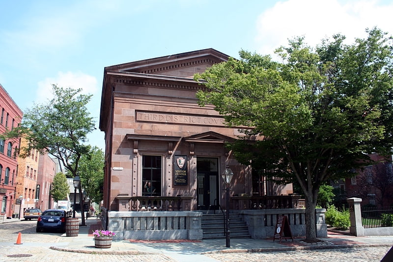
National park in New Bedford, Massachusetts. New Bedford Whaling National Historical Park is a United States National Historical Park in New Bedford, Massachusetts, and is maintained by the National Park Service. The park commemorates the heritage of the world's preeminent whaling port during the nineteenth century.
Established in 1996, the park encompasses 34 acres (fourteen hectares) dispersed over thirteen city blocks. It includes a visitor center, the New Bedford National Historic Landmark District, the New Bedford Whaling Museum, the Seamen's Bethel, the schooner Ernestina, and the Rotch–Jones–Duff House and Garden Museum.
As a National Park, the NBWNHP is rather unusual in that the only properties owned by the NPS are the Visitor Center and the Corson Maritime Learning Center. Rather, the park is a historic district administered under a partnership between the NPS, the City of New Bedford and private building owners to preserve the historic landscapes, structures, and collections and promote research and educational programming associated with the history of whaling. The enabling legislation also established a formal affiliation with the Iñupiat Heritage Center in Utqiaġvik, Alaska, to commemorate the more than 2,000 whaling voyages from New Bedford to the Western Arctic. The city promotes visitation to the park through advertising that calls it "New England's real seaport", as opposed to Connecticut's Mystic Seaport Museum which is a collection of historic buildings and vessels moved from various other locations throughout the region.
Although the famed Whaleman Memorial (commonly called the "Whaleman's Statue") is not within the park's boundaries, it is located only two blocks beyond its western boundary at the corner of William and Pleasant Streets in front of the New Bedford Public Library.[1]
Address: 33 William St, 02740-6222 New Bedford
New Bedford Whaling Museum
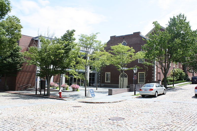
Museum in New Bedford, Massachusetts. The New Bedford Whaling Museum is a museum in New Bedford, Massachusetts, United States that focuses on the history, science, art, and culture of the international whaling industry, and the "Old Dartmouth" region in the South Coast of Massachusetts. The museum is governed by the Old Dartmouth Historical Society, which was established in 1903 "to create and foster an interest in the history of Old Dartmouth." Since then, the museum has expanded its scope to include programming that addresses global issues "including the consequences of natural resource exhaustion, the diversification of industry, and tolerance in a multicultural society." Its collections include over 750,000 items, including 3,000 pieces of scrimshaw and 2,500 logbooks from whaling ships, both of which are the largest collections in the world, as well as five complete whale skeletons. The museum's complex consists of several contiguous buildings housing 20 exhibit galleries and occupying an entire city block within the New Bedford Whaling National Historical Park, although operated independently.
The museum also houses a collection of fine art, including works by major American artists who lived or worked in the New Bedford area, such as Albert Bierstadt, William Bradford, and Albert Pinkham Ryder, as well as a collection of locally produced decorative art, glassware, and furniture associated with the rise of New Bedford as a whaling port in the 19th century.
The museum's Bourne Building houses the Lagoda, a half-scale model of a whaling ship that was commissioned in 1916 and is the world's largest model whaling ship.[2]
Address: 18 Johnny Cake Hl, 02740-6317 New Bedford
Buttonwood Park Zoo
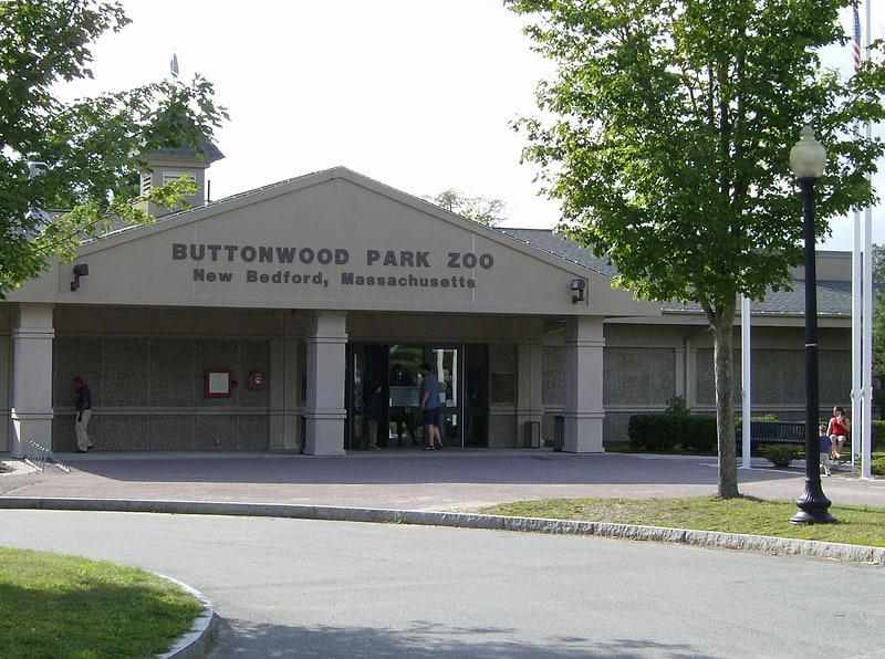
Zoo in New Bedford, Massachusetts. The Buttonwood Park Zoo, located in New Bedford, Massachusetts, United States, is a seven-acre zoo located in the center of Buttonwood Park. It is owned and operated by the City of New Bedford, with the support of the Buttonwood Park Zoological Society.
The zoo opened in 1894 as a deer park and menagerie. In 1995 it was in deplorable condition and closed in 1998. It reopened in 2000 after major renovations. It is home to a variety of North American wildlife and it supports many conservation programs, such as the Cape Cod Stranding Network.[3]
Address: 425 Hawthorn St, 02740-1418 New Bedford
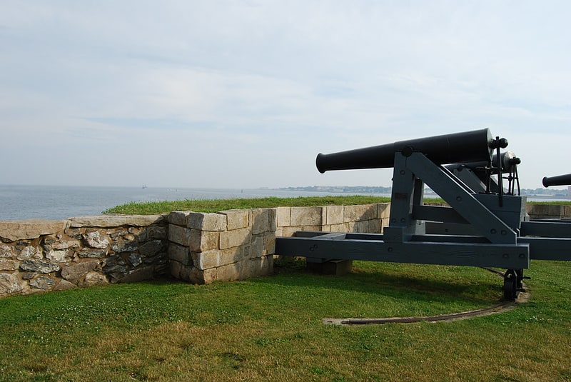
Fort Rodman
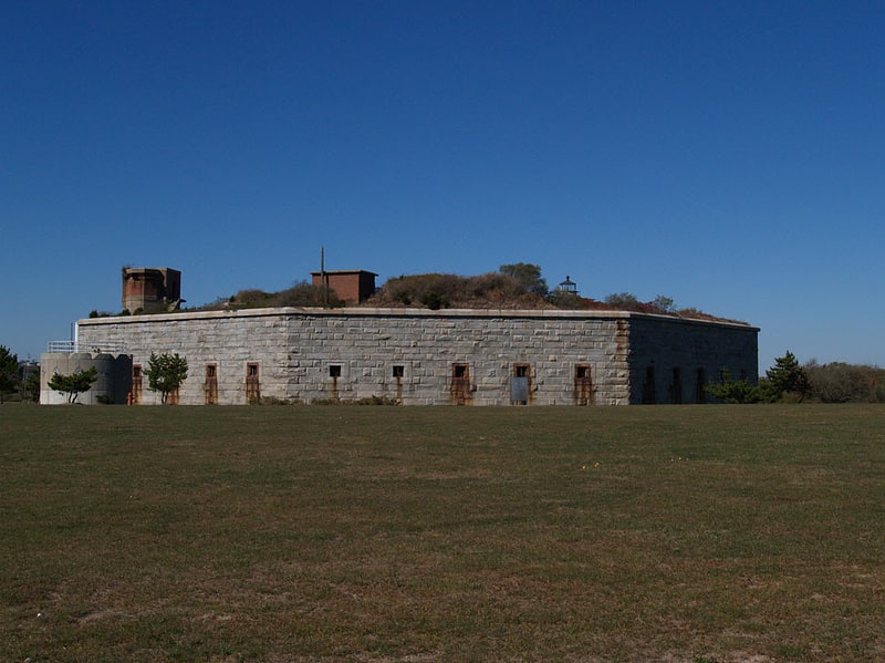
Fort in New Bedford, Massachusetts. Fort Taber District or the Fort at Clark's Point is a historic American Civil War-era military fort on Wharf Road within the former Fort Rodman Military Reservation in New Bedford, Massachusetts. The fort is now part of Fort Taber Park, a 47-acre town park located at Clark's Point. Fort Taber was an earthwork built nearby with city resources and garrisoned 1861-1863 until Fort Rodman was ready for service.[4]
Address: 1000 S Rodney French Blvd, 02744-1223 New Bedford
The Rotch-Jones-Duff House & Garden Museum
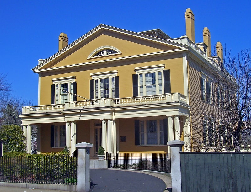
Museum in New Bedford, Massachusetts. The William Rotch Jr. House, now the Rotch–Jones–Duff House and Garden Museum, is a National Historic Landmark at 396 County Street in New Bedford, Massachusetts, in the United States. The three families whose names are attached to it were all closely tied to the city's nineteenth-century dominance of the whaling industry. Because of this, the house is part of the New Bedford Whaling National Historical Park.
Richard Upjohn built the house in the Greek Revival architectural style for William Rotch Jr. in 1834, on a New Bedford plot Rotch had inherited from his father. It was Upjohn's first house, near the beginning of a long career. Rotch also commissioned a garden in the rear, which later owners would significantly expand. The property remained private until 1981, when it was bought by local preservationists and reopened as a historic house museum. It was declared a National Historic Landmark and added to the National Register of Historic Places in 2005. Today the museum educates visitors not only about whaling but, through its gardens and associated programs for local schools, about the environment as well.[5]
Address: 396 County St, 02740-4934 New Bedford
Seamen's Bethel
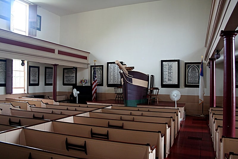
Chapel in New Bedford, Massachusetts. The Seamen's Bethel is a chapel in New Bedford, Massachusetts, United States, located at 15 Johnny Cake Hill.[6]
Address: 15 Johnny Cake Hl, 02740-6318 New Bedford
Fort Phoenix
State park in Fairhaven, Massachusetts. Fort Phoenix is a former American Revolutionary War-era fort located at the entrance to the Fairhaven-New Bedford harbor, south of U.S. 6 in Fort Phoenix Park in Fairhaven, Massachusetts. The fort was originally built in 1775 without a name, and added to the National Register of Historic Places in 1972. Just off the fort, in Buzzards Bay, was the first naval engagement of the American Revolution, the Battle off Fairhaven on 14 May 1775.
On 5–6 September 1778, the fort was destroyed by the British when they raided the harbor. A force under Major Israel Fearing drove off the British, both at the fort and when they attempted an attack on the town the next day. The fort was then renamed Fort Fearing. In 1784 it was given the name "Fort Phoenix" after the mythical bird that rose from its own ashes.
The fort was rebuilt in 1798, and rebuilt again in 1808 with 12 guns with Commonwealth resources, contemporary with but not part of the second system of US fortifications.
In the War of 1812, HMS Nimrod bombarded the fort on 13 June 1814 when the local militia refused to surrender some guns. After an exchange of fire Nimrod sailed away. Local accounts differ as to whether she launched boats carrying a landing party that were driven off, or not. This event is confused in some references with an attack by the same ship on Falmouth on 29 January 1814.
The fort currently has five iron cannons mounted on reproduction wooden carriages. The cannons are Model 1819 24-pounders. Their trunnions are marked, “W.F.” on one side and “1828” on the opposite side, indicating they were cast at the West Point Foundry in Cold Spring, New York, in the year 1828. They were installed at the fort sometime before the Civil War along with three similar guns which were later transferred out of the fort near the end of the war.
There is also a smaller cannon at the fort which was captured by the Continental Marines during the raid on Nassau in the Bahamas in 1776. This raid was the first amphibious landing on foreign soil by United States Marines. This gun has been in Fairhaven since about 1777 and one of those originally installed when the fort was built.
In recent years, two more cannons, mounted on field artillery carriages have been installed at the fort. Donated to the Town of Fairhaven by the New Bedford Whaling Museum, the barrels of the guns are thought to date to the War of 1812, but they have no direct connection to Fort Phoenix.
The fort was rebuilt with a new powder magazine and regarrisoned with eight guns in the Civil War.
During World War II an Anti-Motor Torpedo Boat (AMTB) battery of four towed 37 mm guns was at the fort.
Today, historical encampments are staged at Fort Phoenix in the spring and fall by a local reenacting group, the Fairhaven Village Militia.[7]
Address: Green Street, 02719 Fairhaven
New Bedford Fire Museum
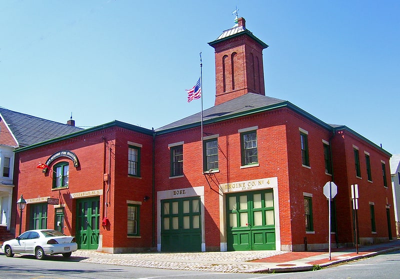
Museum in New Bedford, Massachusetts. The New Bedford Fire Museum is a local history museum at 51 Bedford Street in New Bedford, Massachusetts, United States. It is located in the 1867 Fire Station No. 4, the city's oldest surviving fire station. The building was listed on the National Register of Historic Places in 1975. The museum is open between July 4 and Labor Day. It houses a collection of firefighting equipment and memorabilia related to the history of firefighting in the city.[8]
Address: 51 Bedford St, 02740-4815 New Bedford
Palmer Island Light
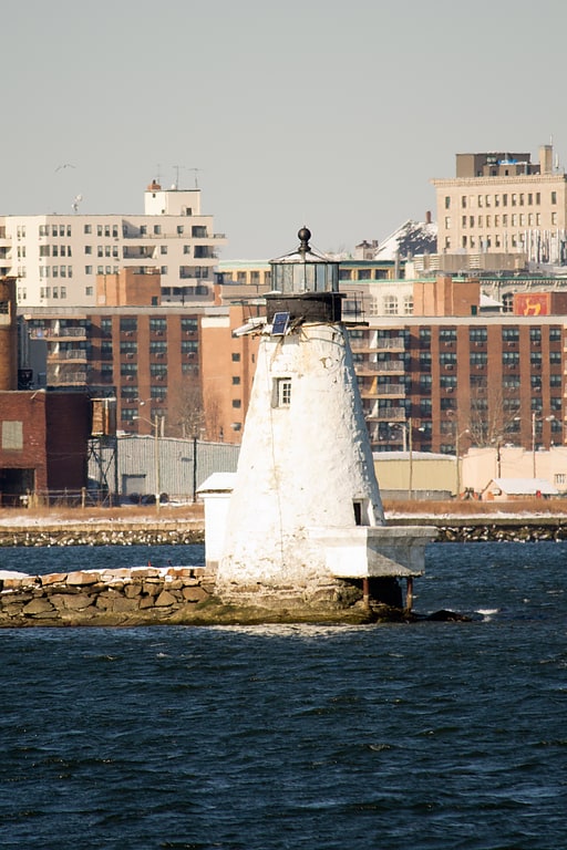
Lighthouse in New Bedford, Massachusetts. Palmer Island Light Station is a historic lighthouse in New Bedford Harbor in New Bedford, Massachusetts, USA. The lighthouse was built in 1849 out of stone rubble. It was discontinued when the harbor's hurricane barrier was built in the early 1960s, as its location immediately north of the barrier was no longer an outlying danger and there are lights on either side of the barrier opening.
From 1888 until 1891 it served, with Fairhaven Bridge Light, as a range light to guide vessels past Butler Flats, a rocky shoal on the west side of the entrance channel.
It was added to the National Register of Historic Places as Palmer Island Light Station on March 26, 1980.[9]
St. Anthony of Padua Church
Church in New Bedford, Massachusetts. St. Anthony of Padua is a Roman Catholic church in New Bedford, Massachusetts, part of the Diocese of Fall River.[10]
Address: 1359 Acushnet Ave, 02746-2024 New Bedford
Buttonwood Park Historic District
Buttonwood Park Historic District is a historic district on Kempton Street, Rockdale Avenue, Hawthorne Street and Brownell Avenue in New Bedford, Massachusetts. Its focal point is Buttonwood Park, a 97-acre municipal park planned by Charles Eliot in the 1890s, and part of its surrounding neighborhood. The neighborhood was developed in the first decades of the 20th century as a complement to the park, and contains a fine selection of Colonial Revival and Craftsman style houses. The district was added to the National Register of Historic Places in 2000.[11]
Unitarian Memorial Church
Unitarian universalist church in Fairhaven, Massachusetts. Unitarian Memorial Church is a historic church on 102 Green Street in Fairhaven, Massachusetts, home to the Unitarian Universalist Society of Fairhaven.
The congregation was founded in 1819, moved into the Washington Street Christian Meetinghouse in 1832, and called its first minister in 1840. The Reverend Jordinn Nelson Long is its currently serving minister, and the Society President is Lawrence DeSalvatore. UUSF is a member congregation of the Boston-based Unitarian Universalist Association, and a designated GLBTQA Welcoming Congregation, a UUA Honor Congregation, and a part of the Green Sanctuary movement. Services are held in the neo-Gothic sanctuary at 10:30 a.m. from September through mid-June each year. The church was added to the National Register of Historic Places in 1996.
The Unitarian Memorial Church in Fairhaven was built, financed and donated to the Unitarians in 1904 by Henry H. Rogers in memory of his mother, Mary Eldredge Huttleston. The church was designed by Boston architect Charles Brigham in a Gothic Revival style. It is one hundred fourteen feet (34.75m) in height, one hundred feet (30.48m) long in body and fifty-three feet (16.15m) wide. The nave is thirty-two feet (9.75m) wide and seventy-one feet (21.64m) long. The main aisle is sixty-two feet (18.90m) long and six feet (1.83m) wide. The church, parish house and former parsonage (now Harrop Center) of the Unitarian Society are so placed as to form three sides of a quadrangle, set among well-kept lawns and shrubbery. Granite (locally quarried) with Indiana limestone decorative carvings dominate the exterior while marble and limestone carvings dominate the interior. All stonework artistry was created by forty-five Italian craftsmen brought to Fairhaven by Rogers.[12]
Butler Flats Light
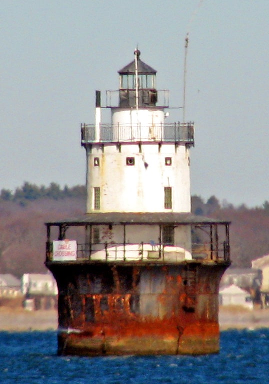
Lighthouse in New Bedford, Massachusetts. Butler Flats Light is a sparkplug lighthouse located in the outer harbor of New Bedford, Massachusetts, at the mouth of the Acushnet River. Built in 1898 by the United States Lighthouse Board, it is the only known caisson lighthouse designed by a marine architect. The light was added to the National Register of Historic Places as Butler Flats Light Station on June 15, 1987. Automated in 1978, it is now operated by the city as a private aid to navigation.[13]
Hazelwood Park
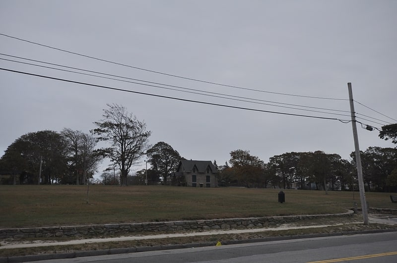
Park in New Bedford, Massachusetts. Hazelwood Park is a public park on Clark's Point in New Bedford, Massachusetts. The park occupies a plot of 23 acres on the west side of New Bedford's southern peninsula, between Rodney French Boulevard and Brock Avenue. It overlooks Clark's Cove which opens into Buzzards Bay. The park was listed on the National Register of Historic Places in 2010.
The park's origins lie in three country estates, which were established in the area during the 19th century. It takes its name from the estate of Joseph Congdon, whose 1839-40 Gothic Revival house stands near the center of the park. Congdon named his estate "Hazelwood", and built an English garden on the then-forested Clark's Point peninsula.
The park also has two later houses: the Coffin-Howland House, which may contain portions of Congdon's carriage house, is fire-damaged and fenced off, and the Howland House, built in 1890, is located near Brock Avenue, and is dominated by its large carriage house and stable.
By the late 1890s, development had encroached on the area, and the city of New Bedford was purchasing land for use as public parks. It acquired the Hazelwood property in 1902. It hired Warren Manning, who had previously worked for Frederick Law Olmsted, to plan the park.[14]
Address: brock ave, 02744 newbedford
Fairhaven

Town in Massachusetts. Fairhaven is a town in Bristol County, Massachusetts, United States. It is located on the South Coast of Massachusetts where the Acushnet River flows into Buzzards Bay, an arm of the Atlantic Ocean. The town shares a harbor with the city of New Bedford, a place well known for its whaling and fishing heritage; consequently, Fairhaven's history, economy, and culture are closely aligned with those of its larger neighbor. The population of Fairhaven was 15,924 at the time of the 2020 census.[15]
United States Customhouse
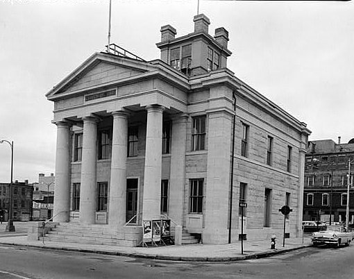
Custom house in New Bedford, Massachusetts. The United States Customhouse is a historic and active custom house at 2nd and William Streets in New Bedford, Massachusetts. Architect Robert Mills designed the custom house in 1834 in a Greek Revival style. It has been used by the U.S. Customs Service ever since, and today serves as a port of entry.
The building was designated a National Historic Landmark and added to the National Register of Historic Places in 1970 for its architectural significance as one of the finest modest Greek Revival government buildings in New England.[16]
Fairhaven High School and Academy
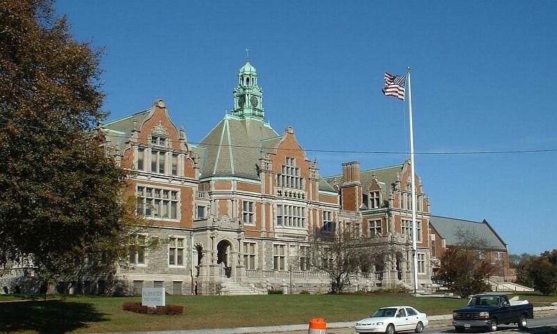
School in Fairhaven, Massachusetts. Fairhaven High School and Academy is a public high school in Fairhaven, Massachusetts, United States. Its main building, built in 1905, is known as the "Castle on the Hill" and it is part of the Fairhaven Public Schools district. The school was voted the "most beautiful high school in Massachusetts" in 2017.
The school building was added to the National Register of Historic Places in 1981. The building was donated in 1906 by Henry Huttleston Rogers, who was one of the key men in John D. Rockefeller's Standard Oil Trust.[17]
Address: 141 Main St, 02719-3118 Fairhaven
Clarks Point Light

Lighthouse in New Bedford, Massachusetts. The Clarks Point Light is located in New Bedford, Massachusetts. Originally constructed as a wooden tower, it was replaced with a stone tower in 1804. This in turn was replaced by a structure on the parapets of Fort Rodman which was deactivated in 1898. After restoration in the early 1970s, it was relit again in 2001 by the city as a private aid.[18]
Fairhaven Town Hall
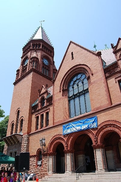
Building in Fairhaven, Massachusetts. Fairhaven Town Hall is the town hall of Fairhaven, Massachusetts. It is located at 40 Center Street, between Walnut and William Streets, across Center Street from the Millicent Library. The brick and stone High Victorian Gothic hall was designed by Charles Brigham and built in 1892. It was given to the town by Henry Huttleston Rogers, who also made other significant contributions to the town, including the library. The building's granite trim elements were quarried in St. George, New Brunswick and Red Beach, Maine.
The town hall was listed on the National Register of Historic Places in 1981.[19]
Address: 40 Center St, New Bedford
Oak Grove Cemetery
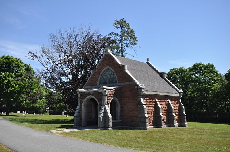
Cemetery in New Bedford, Massachusetts. The Oak Grove Cemetery is a historic cemetery on Parker Street in New Bedford, Massachusetts. It consists of two parcels, separated by Parker Street, northwest of the city's central business district. The older portion of the cemetery, that south of Parker Street, was established in 1843, while the northern section was acquired and developed between 1870 and 1896. Most of the cemetery is laid out in the then-fashionable rural cemetery style of winding lanes, although the northernmost section has a more open layout, made partly due to complaints about the cluttered nature of the rural cemetery style.
The cemetery was listed on the National Register of Historic Places in 2014.[20]