Discover 4 hidden attractions, cool sights, and unusual things to do in Lord Howe Island (Australia). Don't miss out on these must-see attractions: Mount Gower, Mount Lidgbird, and Lord Howe Island Marine Park. Also, be sure to include Erskine Valley in your itinerary.
Below, you can find the list of the most amazing places you should visit in Lord Howe Island (New South Wales).
Table of Contents
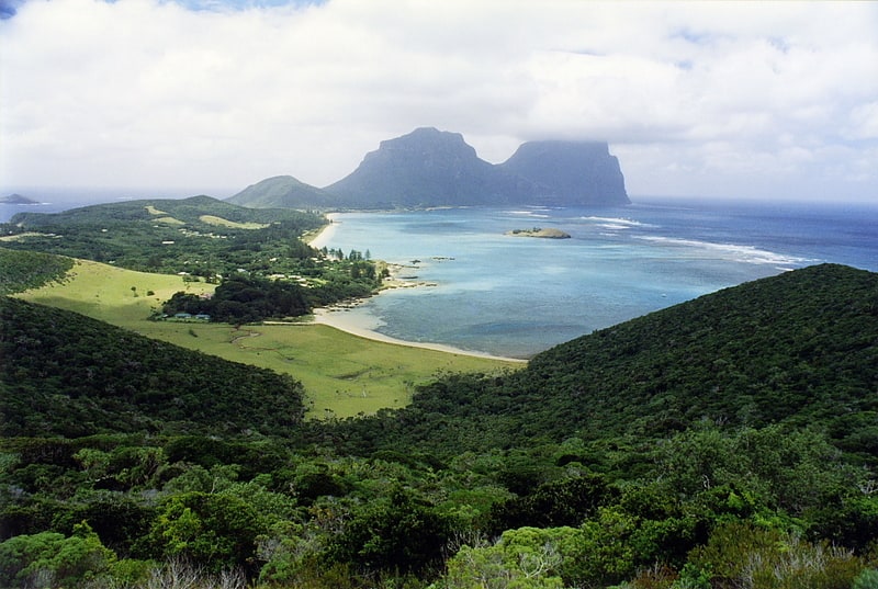
Mount Gower

Mountain in Australia. Mount Gower, is the highest mountain on Australia's subtropical Lord Howe Island in the Tasman Sea. With a height of 875 metres above sea level, and a relatively flat 27-hectare summit plateau, it stands at the southern end of Lord Howe, just south of the island's second highest peak, the 777-metre high Mount Lidgbird, from which it is separated by the saddle at the head of Erskine Valley.
Ascending Gower entails a popular, guided, strenuous 8-hour return hike, though no special climbing skills are needed. The mountain is covered with rainforest, including cloud forest at the summit, containing many of the island's endemic plants.[1]
Mount Lidgbird
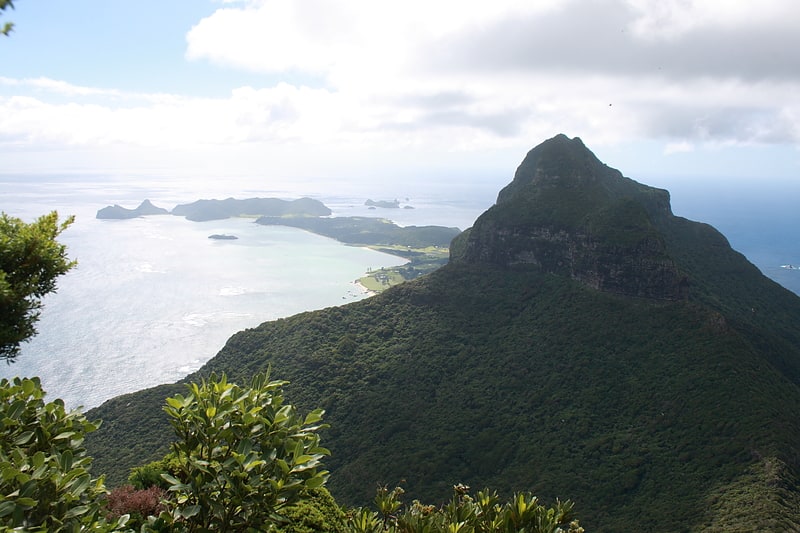
Mount in Australia. Mount Lidgbird, also Mount Ledgbird and Big Hill, is located in the southern section of Lord Howe Island, just north of Mount Gower, from which it is separated by the saddle at the head of Erskine Valley, and has its peak at 777 metres above sea level.
The trek to the summit is for expert climbers only. Ropes are needed to scale the cliffs and slippery, steep terrain. In comparison, Mount Gower is an easy hike. Halfway up the mountain is Goat House Cave, a former shelter for 19th-century Kentia palm gatherers. From this spot, visitors can see nesting masked boobies and numerous red-tailed tropicbirds.[2]
Lord Howe Island Marine Park
Swimming and snorkeling among marine life. Lord Howe Island Marine Park is the site of Australia's and the world's most southern coral reef ecosystem. The island is 10 km in length, 2 km wide and consists of a large lagoonal reef system along its leeward side, with 28 small islets along its coast. In 1999, the waters within three nautical miles of Lord Howe Island were declared a marine park under the NSW Marine Park Act 1997 to protect its unique marine biodiversity, with the park currently being managed by the New South Wales Marine Parks Authority. Both Lord Howe Island and Balls Pyramid are incorporated within the three nautical miles protected by the state marine park. Both marine parks complement the island's status as a World Heritage Site.
Lord Howe Island is located approximately 643 kilometres (400 mi) northeast of Sydney, New South Wales, Australia. Lord Howe Island is remote, has a biologically diverse marine system with a high degree of endemism. Lord Howe Island Marine Park was declared after it was recognised as an area with outstanding natural values, an extraordinary array of marine habitats and biodiversity, rich maritime cultural heritage and social and economic importance to the island community, giving it both national and international importance.[3]
Erskine Valley
Erskine Valley is a small, steep-sided, forested valley, containing the perennial Erskine Creek with several small waterfalls. About one kilometre long and broad, it lies between Mounts Lidgbird and Gower, on the western side of the southern end of Australia’s subtropical Lord Howe Island in the Tasman Sea. The valley is traversed by the popular hiking track to the summit of Mount Gower. It was named after Thomas Erskine, Lord Chancellor of the United Kingdom from 1806 to 1807.
A description of the valley by Robert Etheridge in 1889 reads:
Mounts Ledgbird and Gower are separated by Erskine Valley, or the "Between Hills", a deep and wide depression, running down to the south- west coast. Its descent is very rapid and steep, with more or less permanent water, the sides of the valley being everywhere covered with boulders and volcanic débris, interspersed amongst the densest possible vegetation. The saddle at the head of this declivity, forming the connecting neck between the two hills, is very narrow, probably not more than twenty to thirty yards, covered with large boulders, and supporting a low, stunted vegetation and much under-growth, bearing testimony in the twisted and gnarled condition of the trees to the heavy squalls amid gales which pass across it, and of which we had a vivid personal experience during the night we were camped in this otherwise charming spot. Erskine Valley acts, in fact, as a kind of funnel, and reminded me much of the deep, long gulches with which the Island of St. Helena is cut up. The saddle cannot be far short of 2,000 feet above sea-level.[4]