Discover 10 hidden attractions, cool sights, and unusual things to do in Kaibab National Forest (United States). Don't miss out on these must-see attractions: Keyhole Sink, Grandview Lookout Tower and Cabin, and Red Butte. Also, be sure to include Brow Monument and Brow Monument Trail in your itinerary.
Below, you can find the list of the most amazing places you should visit in Kaibab National Forest (Arizona).
Table of Contents
Keyhole Sink
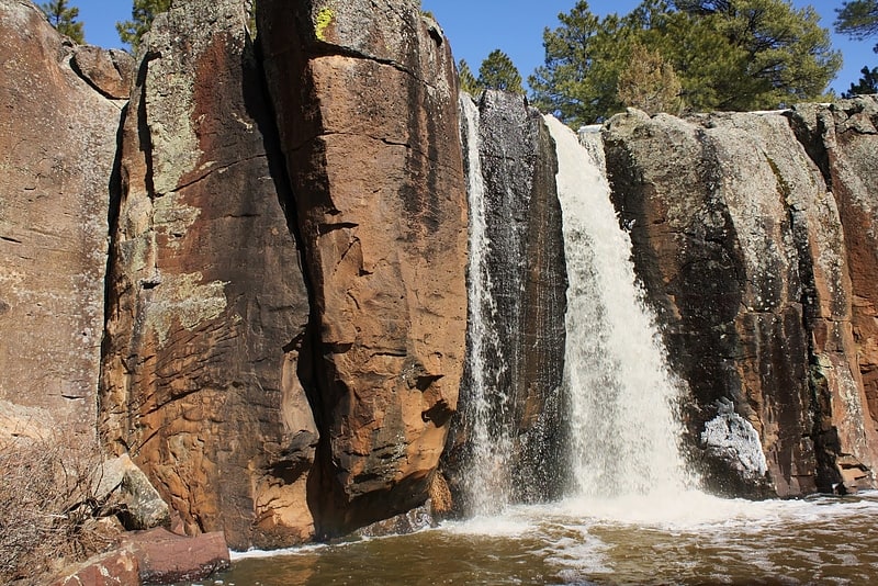
Keyhole Sink is a canyon in the shape of a keyhole near Williams, Arizona. The canyon is best known for its petroglyphs, which were created about 1,000 years ago by the ancient Cohonina people, and the seasonal waterfalls that flow into the canyon.[1]
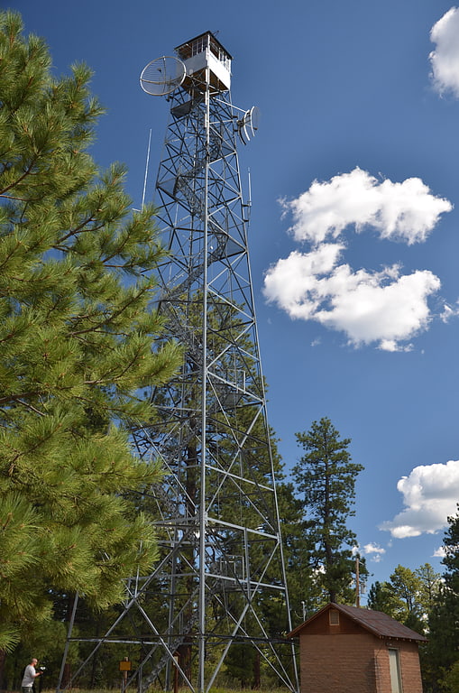
Grandview Lookout Tower and Cabin
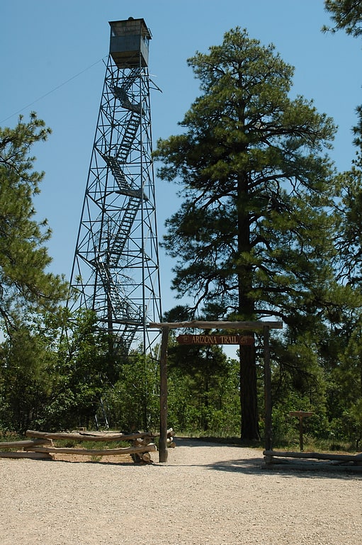
The Grand View Lookout Tower is a fire lookout in Kaibab National Forest near the South Rim of the Grand Canyon. The 80-foot tall steel tower was built in the 1930s. Its observation cabin measures 7 feet square. A small cabin is included in the designated area.
The Arizona Trail passes the tower. The Hull Cabin Historic District is nearby.
The Grandview Lookout Tower was placed on the National Register of Historic Places on January 28, 1988.[2]
Red Butte
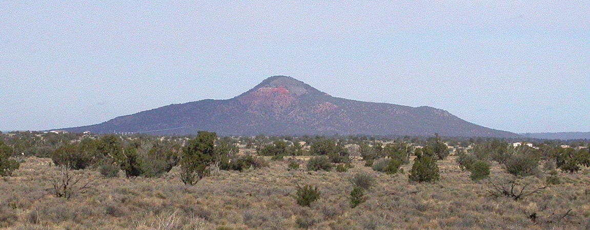
Butte in Arizona. Red Butte is a butte located in the Kaibab National Forest in Coconino County, Arizona. It is known to the Havasupai nation as Wii'i Gdwiisa, "clenched fist mountain," and is regarded as a sacred site.
Red Butte is the most notable feature on the Coconino Plateau between the San Francisco volcanic field and the Grand Canyon. Its base is formed of sandstones of the Moenkopi Formation. Above that are strata of the Shinarump Conglomerate; the summit is capped with volcanic rocks.
A trail leads to the summit along the west side. The summit affords a good view of the San Francisco Peaks, but because of the slope of the Coconino Plateau, only the uppermost part of the North Rim of the Grand Canyon can be seen.[3]
Brow Monument and Brow Monument Trail
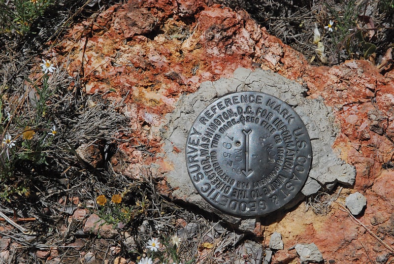
Monument maker in Coconino County, Arizona. The Brow Monument is a monument listed in the National Register of Historic Places for Coconino County, Arizona, located in the Kaibab National Forest. The site contains one of the few remaining survey markers used by the expedition of John Wesley Powell in 1872 It is accessible via the Brow Monument Trail.[4]
Jacob Lake Ranger Station
Building complex in the Coconino County, Arizona. The Jacob Lake Ranger Station is a historic U.S. Forest Service ranger station in the unincorporated community of Jacob Lake, Arizona, United States, that is listed on the National Register of Historic Places.[5]
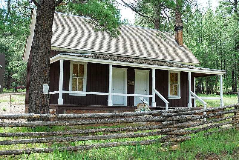
Camp Clover Ranger Station
Building in Coconino County, Arizona. The Camp Clover Ranger Station, about two miles west of Williams, Arizona, was built in 1934 by the Civilian Conservation Corps. It was listed on the U.S. National Register of Historic Places in 1993 for its architecture. It was designed by the USDA Forest Service in Bungalow/Craftsman style. It served historically as institutional housing and government office space.
The listing included five contributing buildings (an office, a residence, a barn/garage, a shed, and a one-car garage), and one contributing structure (a corral) on 3 acres (1.2 ha).[6]
Ashfork-Bainbridge Steel Dam
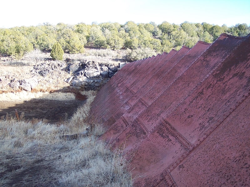
Historical landmark in Coconino County, Arizona. The Ashfork Bainbridge Steel Dam, the first large steel dam in the world, and one of only three ever built in the United States, was constructed in 1898 by the Atchison, Topeka and Santa Fe Railway to supply water for railway operations near Ash Fork, Arizona. It is named for the town of Ash Fork, and for Francis H. Bainbridge, a civil engineer and graduate of Rensselaer Polytechnic Institute, a member of the Rensselaer Society of Engineers, and an engineer for ATSF. The dam has been listed on the National Register of Historic Places since 1976.[7]
Hull Cabin Historic District
The Hull Cabin was built in the late 1880s near the South Rim of the Grand Canyon by settler William Hull. The Hull family arrived in the area in 1880 and established a ranch in the area, raising sheep and building the Hull Tank, a large earth-banked reservoir for their stock. The Hulls branched out into prospecting and were among the first to take in tourists heading to the Grand Canyon.
In 1893 the lands surrounding the Hull property were designated the Grand Canyon Forest Reserve. At some point after 1893 Hull left the area, and the cabins became property of the Department of the Interior. The cabin site was located near the somewhat boundary between Grand Canyon National Monument and Coconino National Forest, and at various times was considered to be within either property. However, on February 21, 1907 the cabin and its dependencies were transferred to Coconino National Forest, becoming the Hull Tank Ranger Station. In 1910 the cabin became the Hull Tank Ranger Station, the headquarters for Tusayan National Forest, which was created from Coconino. The forest managed the Grand Canyon area until the creation of the national park in 1919, working from the Hull Cabin in summer and from Anita, Arizona in the winter. Tusayan was incorporated into Kaibab National Forest in 1934. and the cabin became the headquarters of the Tusayan District until 1940, when operations were moved to the Moqui Ranger Station near Tusayan. The cabin's rear extension was added at that time, and probably the stone living room chimney. A 1950 proposal was advanced to include the area around the Hull Cabin in Grand Canyon National Park, but the idea was never pursued.[8]
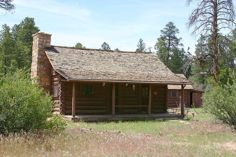
Big Springs Lookout Tower
Tower in Coconino County, Arizona. The Big Springs Lookout Tower is a fire lookout tower in Kaibab National Forest near Big Springs, Arizona. The tower was built in 1934 for the U.S. Forest Service by contractors from Kanab, Utah. The steel tower is 100 feet tall and features a 7-foot square cab at the top. A wood-frame cabin is located near the base of the tower; the cabin was built in 1959 to replace an older log cabin.
The tower was listed on the National Register of Historic Places in 1988.[9]
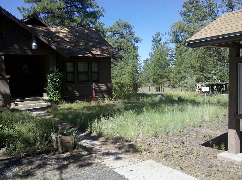
Big Springs Ranger Station
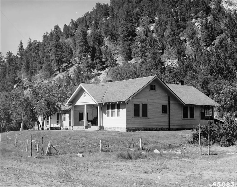
Building in Coconino County, Arizona. The Big Springs Ranger Station is a ranger station located in Kaibab National Forest near Big Springs, Arizona. The ranger station was built by the Civilian Conservation Corps in 1934. The complex includes a house, an office building, and a barn with an attached corral; while these are the only contributing structures to the district, it also includes a number of outbuildings. U.S. Forest Service architects designed the buildings in a Bungalow style characteristic of Forest Service architectural plans during the 1930s.
The ranger station was added to the National Register of Historic Places on June 10, 1993.[10]