Discover 11 hidden attractions, cool sights, and unusual things to do in Canaima National Park (Venezuela). Don't miss out on these must-see attractions: Angel Falls, Kukenán-tepui, and Gran Sabana. Also, be sure to include Auyán-tepui in your itinerary.
Below, you can find the list of the most amazing places you should visit in Canaima National Park (Bolívar).
Table of Contents
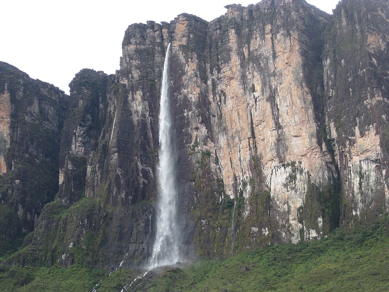
Angel Falls
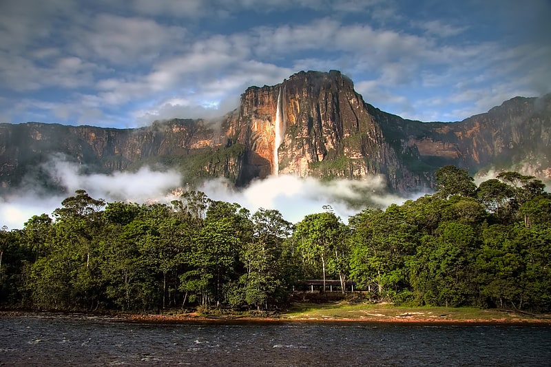
Also known as: Salto Ángel
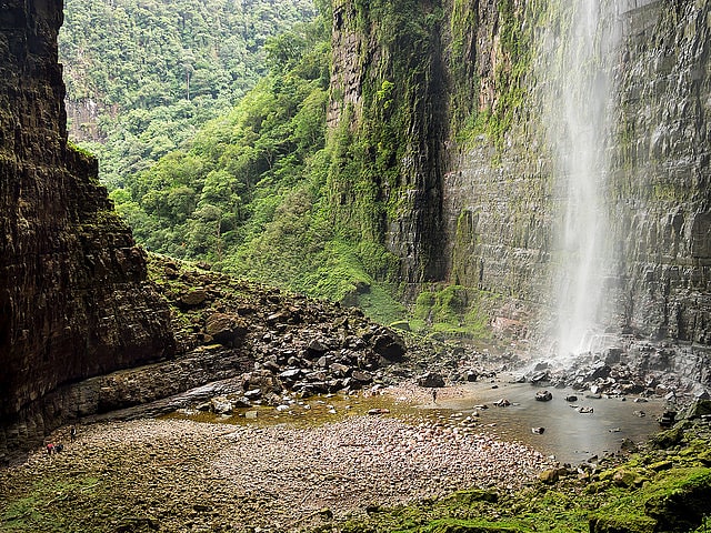
Highest waterfall in the world. Angel Falls is a waterfall in Venezuela. It is the world's tallest uninterrupted waterfall, with a height of 979 metres and a plunge of 807 m. The waterfall drops over the edge of the Auyán-tepui mountain in the Canaima National Park, a UNESCO World Heritage site in the Gran Sabana region of Bolívar State. The height figure, 979 m, mostly consists of the main plunge but also includes about 400 metres of sloped cascade and rapids below the drop and a 30-metre-high plunge downstream of the talus rapids.
The falls are along a fork of the Río Kerepacupai Merú which flows into the Churún River, a tributary of the Carrao River, itself a tributary of the Orinoco River.[1]
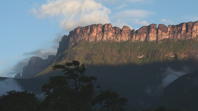
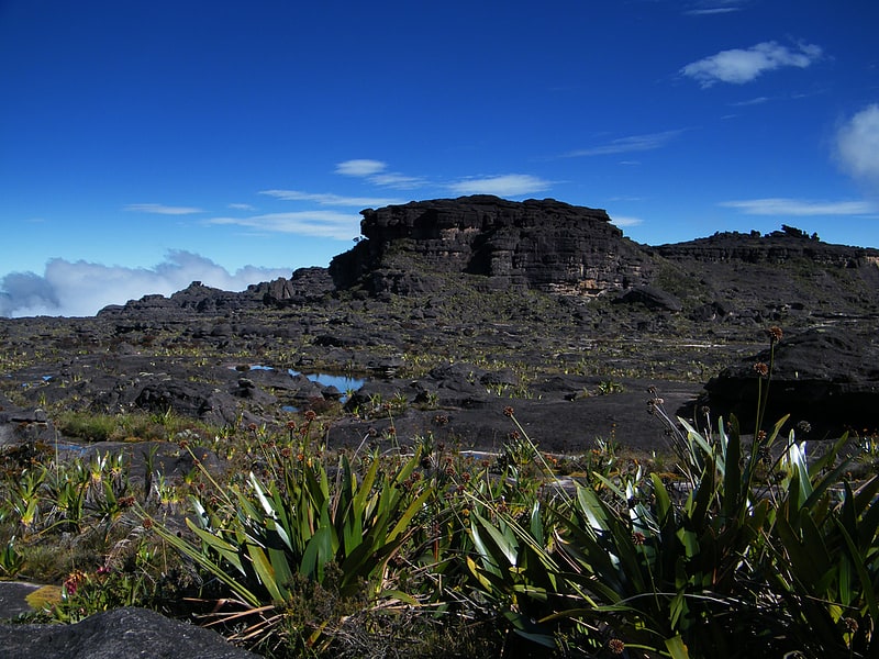
Kukenán-tepui
Also known as: Tepuy Kukenán
Kukenán, also known as Matawi or Cuquenán, is a tepui in Bolívar State, Guyana Region, Venezuela. It has an estimated surface area of 2185 hectares. It is 2,680 metres high and about 3 km long. Kukenan Falls, which is 674 m high, is located at the south end of the tepui.
Kukenán is located in Canaima National Park. Next to Kukenán, to the southeast, is Mount Roraima, a better known tepui. Kukenán is more difficult to climb, so it is ascended much less frequently than Mount Roraima.
Canaima National Park is also home to the highest waterfall in the world, which is located in Auyán Tepui.
Scenery on top of Kukenán provided inspiration for the 2009 film Up.[2]
Gran Sabana
Region in Venezuela. La Gran Sabana is a region in southeastern Venezuela, part of the Guianan savanna ecoregion.
The savanna spreads into the regions of the Guiana Highlands and south-east into Bolívar State, extending further to the borders with Brazil and Guyana. The Gran Sabana has an area of 10,820 km2 (4,180 sq mi) and is part of the second largest National Park in Venezuela, the Canaima National Park. Only Parima Tapirapecó National Park is larger than Canaima. The average temperature is around 20 °C (68 °F), but at night can drop to 13 °C (55 °F) and in some of the more elevated sites, depending on weather, may drop a bit more.
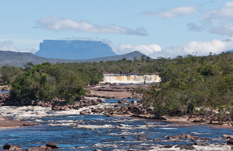
The location offers one of the most unusual landscapes in the world, with rivers, waterfalls and gorges, deep and vast valleys, impenetrable jungles and savannahs that host large numbers and varieties of plant species, a diverse fauna and the isolated table-top mesas locally known as tepuis.[3]
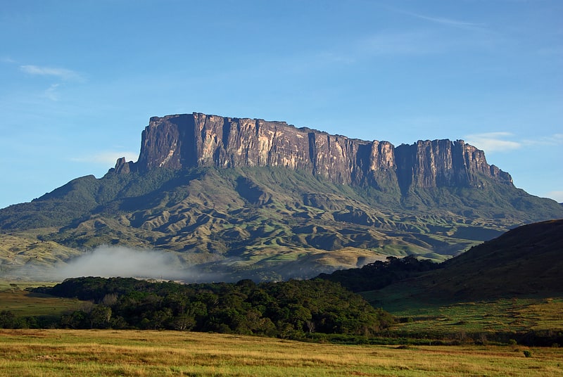
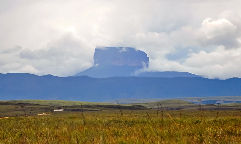
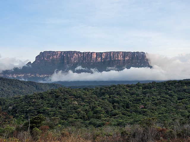
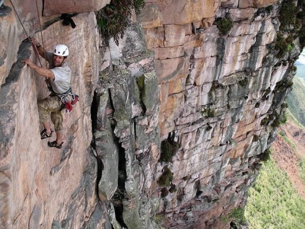
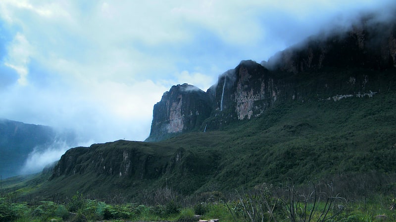
Auyán-tepui
Also known as: Auyantepui
Mountain in Venezuela. Auyán Tepui, also spelled Ayan, is a tepui in Bolívar state, Venezuela. It is the most visited and one of the largest tepuis in the Guiana Highlands, with a summit area of 666.9 km2 and an estimated slope area of 715 km2. The unevenly heart-shaped summit plateau of Auyán-tepui is heavily inclined, rising from around 1,600 metres in the northwest to a maximum of 2,450 m in the southeast. It is incised from the north by a vast valley, the Cañón del Diablo, formed by the Churún River. The larger western portion of the plateau is partially forested, whereas the eastern part comprises mostly bare rock with only patchy vegetation cover. The mountain hosts a number of extensive cave systems.
Auyán-tepui gives its name to the Auyán Massif, which also includes the tiny peaks of Cerro El Sol and Cerro La Luna to the north, and the satellite mountain of Uaipán-tepui to the south. The massif has a total summit area of roughly 670 km2 (260 sq mi) and an estimated slope area of 795 km2 (307 sq mi). It is situated entirely within the bounds of Canaima National Park. Auyán-tepui means "Devil's House" in the local Pemón language.
Angel Falls, the tallest waterfall in the world, drops from a cleft near the summit. The falls are 979 meters (3,212 ft) high, with an uninterrupted descent of 807 meters (2,648 ft) — a drop nineteen times higher than that of Niagara Falls.
Auyán-tepui achieved international fame in 1933 when Angel Falls was accidentally discovered by Jimmie Angel, a bush pilot searching for gold ore. Attempting to land on the heart-shaped mesa in 1937, Angel crashed his small Flamingo plane on top of Auyán-tepui and was forced to hike down the gradually sloping backside, a trip that took him and his crew 11 days to complete; he was immortalised when the waterfall was named after him.
Around 25 species of amphibians and reptiles are known from the summit plateau of Auyán-tepui, as well as numerous birds. Like many tepuis, the mountain hosts a rich assemblage of flora.[4]
Maverick Rock
Maverick Rock or Maverick Stone is a natural rock formation in Venezuela, on top of Mount Roraima. It is the highest point of that tabletop mountain, at 2,810 metres a.m.s.l. The rock stands near the southwestern edge of the mountain plateau. Although Mount Roraima is shared with Guyana and Brazil, Maverick Rock is entirely within internationally recognized Venezuelan territory, in the state of Bolívar, of which it is the highest point.
The rock's name comes from the apparent similarity of its shape to a Ford Maverick automobile.[5]
Ptari-tepui
Also known as: Ptarí
Summit in Venezuela. Ptari-tepui, also spelled Pu-tari and sometimes called Cerro Budare or Cerro del Budare, is a tepui in Bolívar state, Venezuela. Lying near the centre of the Sierra de Lema, it has a maximum elevation of around 2,400 metres above sea level. Its mostly bare summit plateau has an area of 1.25 km2. Though generally flat, distinctive erosional rock formations are found on the more dissected eastern edge of the summit.[6]
Aprada-tepui
Also known as: Aprada
Summit in Venezuela. Aprada-tepui is a tepui in Bolívar state, Venezuela. It has an elevation of around 2,500 metres above sea level. It gives its name to the Aprada Massif, which also includes the smaller Araopán-tepui to the east. A steep, semi-circular ridge connects these two summits. Aprada-tepui lies 22 kilometres northwest of the much larger Chimantá Massif and around 25 km east of the Pemón village of Urimán.
Aprada-tepui has a summit area of 4.37 km2 (1.69 sq mi) and, together with Araopán-tepui, an estimated slope area of 210 km2 (81 sq mi). Both peaks are situated entirely within the bounds of Canaima National Park.[7]
Cueva del Fantasma
Cueva de El Fantasma is a giant cave in southern Venezuela, located in one of the most biologically rich, geologically ancient parts of the world, along the slopes of Aprada-tepui. Large enough for two helicopters to land in the cave, the report from Zootaxa is said to be the first photographic evidence of such an immense cave. However, experts note, it is not technically a cave, but rather a collapsed, steep gorge.[8]
Upuigma-tepui
Also known as: Upuigma
Peak in Venezuela. Upuigma-tepui, also known as El Castillo, is a tepui in Bolívar state, Venezuela. A relatively isolated peak, both it and nearby Angasima-tepui lie just south of the vast Chimantá Massif, from which they are separated by the Río Aparurén valley. Upuigma-tepui is situated entirely within the bounds of Canaima National Park.
The imposing peak of Upuigma-tepui has an elevation of around 2,100 metres (6,900 ft). Its highly uneven summit is dotted with numerous rock towers and deep crevasses which make it practically impossible to traverse. Summit vegetation is predominantly in the form of tepui scrub and dense stands of herbaceous plants. The mountain has a summit area of 0.63 km2 (0.24 sq mi) and an estimated slope area of 13 km2 (5.0 sq mi).
The first documented people to climb Upuigma-tepui were John Arran, Ivan Calderon and Steve Backshall, in 2007. Upon reaching the summit, they discovered several previously unknown species of plants and animals.[9]
Cuquenan Falls
Also known as: Salto Cuquenán
Waterfall in Venezuela. Kukenan Falls is the second tallest major waterfall in Venezuela after Angel Falls. It is also the second tallest free-leaping waterfall in the world. Overall, it is usually cited as the 11th highest waterfall in the world. The falls drop in a single leap of around 2,211 feet and the final portion of the falls trickles down towards the base of the Kukenan Tepui.
The Kukenan Tepui is located near Mount Roraima, which serves as the geographical marker of the border between Brazil, Venezuela, and Guyana. Mount Roraima also hosts its own waterfall, usually referred to as Roraima Falls, which leaps off the tepui in four tiered leaps. The height is estimated at approximately 2,000 feet (610 m).[10]
Pacaraima Mountains
Also known as: Sierra de Pacaraima
Mountain range in Venezuela. The Pacaraima or Pakaraima Mountains are a mountain range primarily in southwestern Guyana, and into northern Brazil and eastern Venezuela.[11]