Discover 11 hidden attractions, cool sights, and unusual things to do in Black Hills National Forest (United States). Don't miss out on these must-see attractions: Elk Mountains, Pactola Lake, and Pactola Dam. Also, be sure to include Sheridan Lake in your itinerary.
Below, you can find the list of the most amazing places you should visit in Black Hills National Forest (South Dakota).
Table of Contents
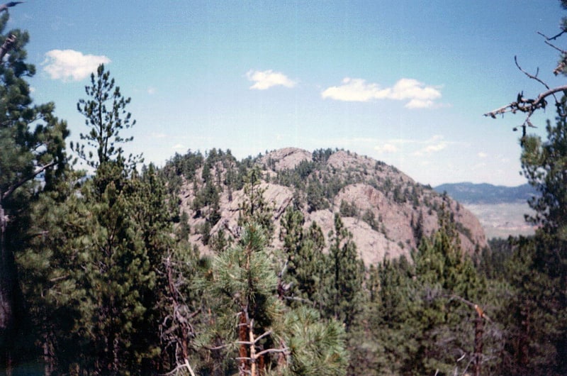
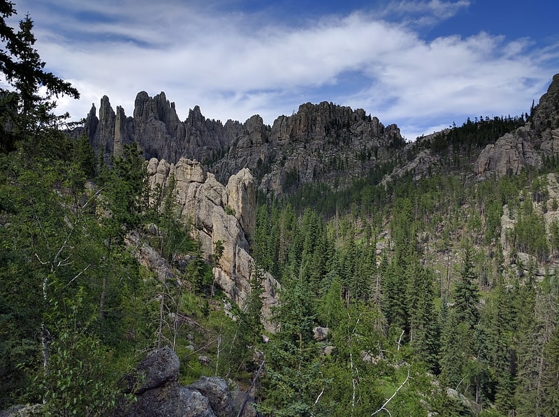
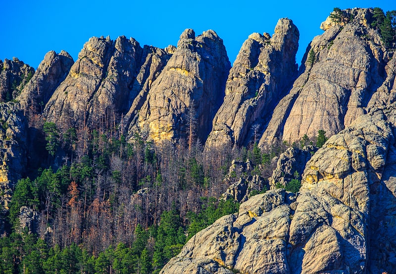
Elk Mountains
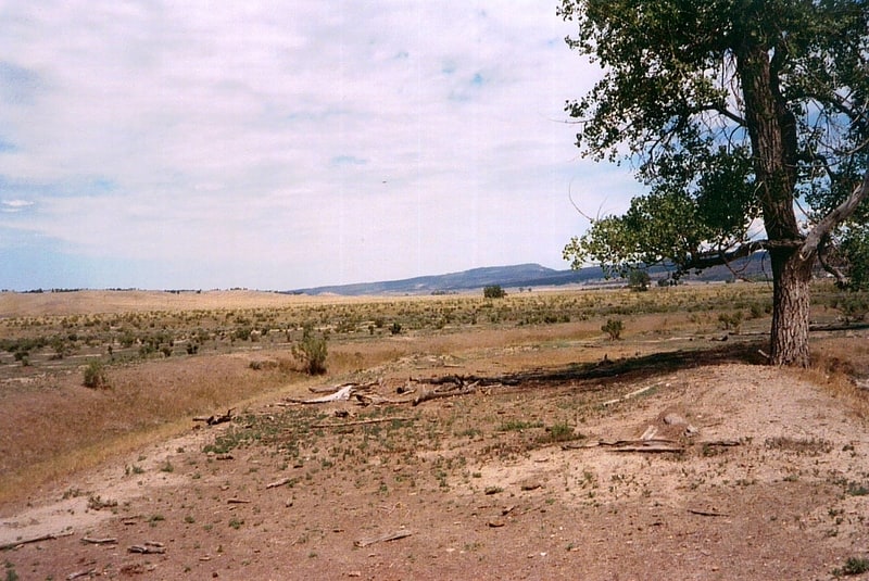
Geographical feature. The Elk Mountains are a small range of mountains in western South Dakota, forming the southwest portion of the Black Hills as part of its west-dipping monocline. They are geologically distinct from the Black Hills, on the other side of a "racetrack" region of red stone. The ridge of the Elk Mountains is formed of harder sandstones. The east face of the Elk Mountains is a 300-to-800-foot high escarpment, but the west portion falls slowly and features many canyons.
Most of the Elk Mountains were protected in the Harney National Forest until 1954, when this protected area joined the Black Hills National Forest. Today the large South Dakota portion of the mountain range is in the Hell Canyon District of the Black Hills National Forest, while the much smaller Wyoming portion lies in the Bearlodge District. The Elk Mountains are one of three mountain ranges that comprise the Black Hills region and national forest, including the Black Hills itself and Wyoming's Bear Lodge Mountains.
Elk Mountain is the highest point of the range and has a lookout tower on its summit. Other peaks include Pilger Mountain and Sullivan Peak.
Few people live in or near the Elk Mountains. The closest town is Edgemont, South Dakota, to the south. Tiny unincorporated Dewey and ghost town Burdock lie to the west. Ten miles to the northwest is Newcastle, Wyoming.[1]
Pactola Lake
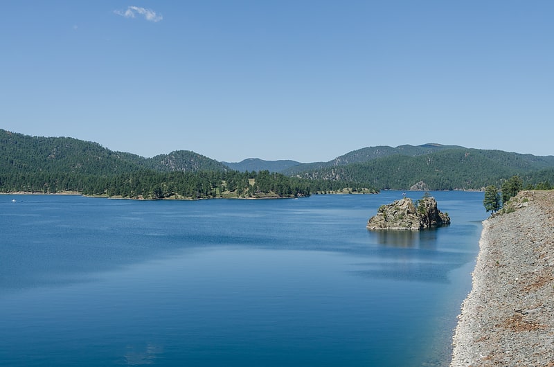
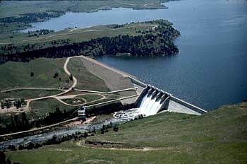
Reservoir in South Dakota. Pactola Lake is the largest reservoir in the Black Hills of South Dakota, United States; it was created by the construction of the Pactola Dam. It was started on 25 November 1952. Contrary to popular belief there is no town at the bottom of Pactola Lake. The Bureau of Reclamation clear cut and cleaned the lake bottom before it filled. The few buildings still there by the time the dam was finished on August 15, 1956 were moved or auctioned off. The only structure under the water is the old Civilian Conservation Corp camp dynamite bunker.
The lake is located on Rapid Creek in Pennington County, South Dakota. The lake provides the water supply for the Rapid City Metro Area. It is owned and operated by the US Bureau of Reclamation, with the various recreational facilities operated by the US Forest Service, and is one of the recreational areas of Black Hills National Forest. Boating and fishing are very popular, with a walk-in fly fishing area located on Rapid Creek below the dam.
Facilities include a marina, improved swimming beach, campgrounds and group campground on the south shore, campgrounds and a handicapped fishing path on the north shore, and various picnic and overlook areas. In the summer, the USFS operates a visitor center on the dam, immediately off US Highway 385. The dam across Rapid Creek is very large, and was enlarged following the Black Hills Flood of 1972; lake water levels vary enormously, as the lake is used for flood control, domestic water, streamflow maintenance, and irrigation.
Pactola Lake is accessible via US Highway 385 north from Hill City, South Dakota and Sheridan Lake Forks or south from Lead and Deadwood; or via the Rimrock Highway (also known as SD Highway 44), from Rapid City, South Dakota. Fees are charged in summertime for all facilities. Boating (both power and sail), fishing, swimming, and other outdoor activities are popular in the summer; in wintertime, ice-fishing, ice-skating, and some cross-country skiing is popular.
The small town of Silver City is located at the upstream end of the lake; downstream on Rimrock Highway and Rapid Creek are the communities of Johnson Siding, Hisega, Upper Hisega, Placerville, and Big Bend.[2]
Pactola Dam
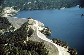
Pactola Dam is an embankment dam on Rapid Creek in Pennington County, South Dakota, about 10 miles west of Rapid City. The dam was completed in 1956 by the U.S. Bureau of Reclamation to provide flood control, water supply and recreation. Along with the nearby Deerfield Dam, it is part of the Rapid Valley Unit of the Pick-Sloan Missouri Basin Program. U.S. Route 385 runs along the crest of the dam. The dam forms Pactola Lake, which at over 1,200 acres is the largest and deepest body of water in the Black Hills.[3]
Sheridan Lake
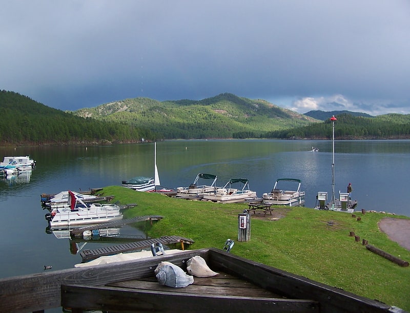
Lake in South Dakota. Sheridan Lake, a reservoir, is located on Spring Creek in Pennington County, South Dakota. Built over the site of Sheridan, the first county seat, it is owned and operated by the United States Forest Service and is one of the recreational areas of the Black Hills National Forest.[4]
Crazy Horse Memorial
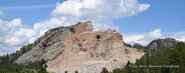
Top attraction, Monuments and statues, View point, Memorial
Address: 12151 Avenue of the Chiefs, 57730-8900 Crazy Horse
Keystone Wye
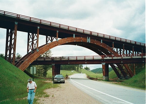
Bridge in Pennington County, South Dakota. Keystone Wye is an interchange of U.S. Route 16 and US 16A located in the Black Hills of South Dakota, featuring two unique structural glued laminated timber bridges. The Keystone Wye is a three-level Directional T interchange for the two divided highways, constructed in 1967-1968 as part of a project by the South Dakota Department of Transportation to convert US 16 to a four-lane highway between Rapid City and Keystone. It was designed by Clyde Jundt and Kenneth C. Wilson.
The high bridge (see photo in external reference) is supported by three 20-meter (66 ft) wooden, single-hinged arches; six separate glued laminated timber pieces are used in the construction. Three more pieces were built but failed quality assurance tests; they were assembled into an interesting pyramidal sculpture which for years was located just off US 16 on the then-south edge of Rapid City (a site today occupied by a motel and convenience store), and which was moved to a new location on US 16 near the Sitting Bull Crystal Cavern Dance Pavilion in the mid-1990s.
The name Keystone Wye significantly predates the construction of the modern interchange, and dates back to the 1930s and the construction of Mount Rushmore, when Senator and Governor Peter Norbeck laid out a series of roadways in the south-central Black Hills for tourist travel, focusing on Mount Rushmore and Harney Peak (now Black Elk Peak). The Keystone Wye includes a lay-by with historic and scenic information about the area, a SDDOT maintenance yard, and several minor roads connecting to the major highways. In the late 1980s, US 16A between the Keystone Wye and Keystone itself was widened to a four-lane undivided highway, with the single tunnel on the road expanded to accommodate the wider roadway. In the early 2000s, US 16 between the Keystone Wye and Three Forks was improved to a "Super-Two" configuration with passing lanes on most hills, although the alignment was unchanged from the 1980s realignment project which created many cutoff loops on the highway.[5]
Inyan Kara Mountain
Mountain in Wyoming. Inyan Kara Mountain is a mountain associated with the Bear Lodge Mountains of Crook County, Wyoming that is considered sacred by the Lakota people, particularly for mothers in childbirth. Inyan Kara stands apart from the main body of the Black Hills, with an elevation of 6,368 feet. The mountain was stated to rumble on quiet days by the local Native Americans and by early explorers. No mention of the noises are found after 1833; the noise has been attributed to gas escaping from burning coal seams.
The peak was visited by George Armstrong Custer during Custer's 1874 Black Hills Expedition, reaching the summit on July 23.
The peak was placed on the National Register of Historic Places in 1973.[6]
Angostura Dam
Historical landmark in Fall River County, South Dakota. Angostura Dam is an embankment dam across the Cheyenne River in Fall River County in southwestern South Dakota in the United States, about 75 miles south of Rapid City. The dam consists of an earth-fill embankment with a concrete spillway section, 193 feet high and 2,030 feet long; it withholds the 195,121-acre-foot Angostura Reservoir. The dam was conceived as early as 1913, but it was not until the 1930s when a regional drought caused crop failures that the project received widespread support from farmers. Built from 1946 to 1949, the dam is part of the Angostura Division of the Pick-Sloan Missouri Basin Program, and is operated by the U.S. Bureau of Reclamation.
The dam's primary purpose is to store water for the irrigation of 12,218 acres (4,944 ha) of project lands. The service area lies along 24 miles (39 km) of the Cheyenne River below the dam, and is supplied by the Angostura Canal, which has a diversion capacity of 290 cubic feet per second (8.2 m3/s). The dam and reservoir regulate runoff from an area of 9,034 square miles (23,400 km2). The reservoir has a conservation storage capacity of 138,761 acre-feet (0.171159 km3), with an extra 56,740 acre-feet (0.06999 km3) of surcharge, flood-control storage. Flood water releases are controlled by a spillway with five radial gates, which can pass up to 247,000 cu ft/s (7,000 m3/s).
Angostura Reservoir is one of the only large lakes in western South Dakota. With 36 miles (58 km) of shoreline and 4,706 acres (1,904 ha) of water, the reservoir is stocked with several species of fish, including walleye, smallmouth bass and crappie.
The Angostura Recreation Area operated by the South Dakota Department of Game, Fish, and Parks surrounds the lake.[7]
Black Hills
Mountain range in the United States of America. The Black Hills are a small and isolated mountain range rising from the Great Plains of North America in western South Dakota and extending into Wyoming, United States. Black Elk Peak, which rises to 7,244 feet, is the range's highest summit. The Black Hills encompass the Black Hills National Forest. The name "Black Hills" is a translation of the Lakota Pahá Sápa. The hills are so called because of their dark appearance from a distance, as they are covered in evergreen trees.
Native Americans have a long history in the Black Hills. After conquering the Cheyenne in 1776, the Lakota took the territory of the Black Hills, which became central to their culture. In 1868, the U.S. government signed the Fort Laramie Treaty of 1868, establishing the Great Sioux Reservation west of the Missouri River, and exempting the Black Hills from all white settlement forever. However, when settlers discovered gold there in 1874, as a result of George Armstrong Custer's Black Hills Expedition, miners swept into the area in a gold rush. The US government took the Black Hills and forcibly relocated the Lakota, following the Great Sioux War of 1876, to five smaller reservations in western South Dakota, selling off 9 million acres (36,000 km2) of their former land. Unlike most of South Dakota, the Black Hills were settled by European Americans primarily from population centers to the west and south of the region, as miners flocked there from earlier gold boom locations in Colorado and Montana.
As the economy of the Black Hills has shifted away from natural resources (mining and timber) since the late 20th century, the hospitality and tourism industries have grown to take its place. Locals tend to divide the Black Hills into two areas: "The Southern Hills" and "The Northern Hills." The Southern Hills is home to Mount Rushmore, Wind Cave National Park, Jewel Cave National Monument, Black Elk Peak (the highest point in the United States east of the Rockies, formerly and still more commonly known as Harney Peak), Custer State Park (the largest state park in South Dakota), the Crazy Horse Memorial, and The Mammoth Site in Hot Springs, the world's largest mammoth research facility.
Attractions in the Northern Hills include Spearfish Canyon, historic Deadwood, and the Sturgis Motorcycle Rally, held each August. The first Rally was held on August 14, 1938, and the 75th Rally in 2015 saw more than one million bikers visit the Black Hills. Devils Tower National Monument, located in the Wyoming Black Hills, is an important nearby attraction and was the United States' first national monument.[8]
Harney National Forest
Harney National Forest was established by the U.S. Forest Service in South Dakota and Wyoming on July 1, 1911 with 642,550 acres from part of Black Hills National Forest and other lands. On July 1, 1954 the entire forest was added to Black Hills and the name was discontinued.[9]
Bear Lodge Mountains
Mountain in Wyoming. The Bear Lodge Mountains are a small mountain range in Crook County, Wyoming. These mountains are protected in the Black Hills National Forest as part of its Bearlodge District. Devils Tower National Monument was the first U.S. National Monument and draws about 400,000 visitors per year to the area. The Bear Lodge Mountains are one of three mountain ranges that comprise the Black Hills region and national forest, including the Black Hills itself and South Dakota's Elk Mountains.
Sundance, Wyoming is the closest major city and lies south of the Bear Lodge Mountains. Wyoming Highway 24 (the Bear Lodge Highway) passes through the northern part of the range.[10]