Discover 11 hidden attractions, cool sights, and unusual things to do in Bighorn National Forest (United States). Don't miss out on these must-see attractions: Shell Falls, Medicine wheel, and Medicine Wheel/Medicine Mountain National Historic Landmark. Also, be sure to include Cloud Peak in your itinerary.
Below, you can find the list of the most amazing places you should visit in Bighorn National Forest (Wyoming).
Table of Contents
Shell Falls
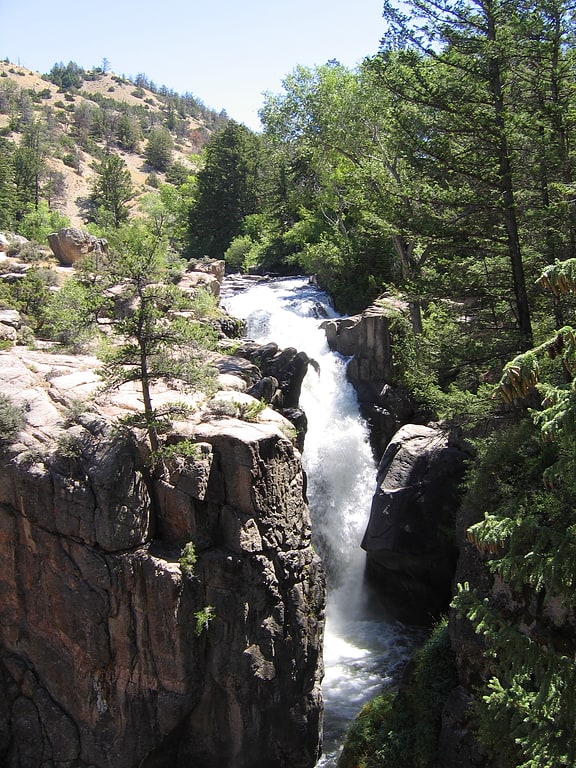
Waterfall in Wyoming. Shell Falls is a waterfall in the Bighorn National Forest on Shell Creek, about halfway down Shell Canyon, and a few miles upstream from the town of Shell in northeast Wyoming. The falls are 120 feet in height and tumble over basement rock of granite.
From the rest area and interpretive center, one can see outcrops of the Cambrian flathead sandstone, about 550 million years old, resting on 2.9 billion year old Precambrian rocks—some of the oldest rocks on earth. Visitors can also see "Copman's Tomb", a massive limestone promontory to the north.[1]
Address: U.S. 14, Bighorn National Forest, Bighorn National Forest
Medicine wheel
To some indigenous peoples of North America, the medicine wheel is a metaphor for a variety of spiritual concepts. A medicine wheel may also be a stone monument that illustrates this metaphor.
Historically, most medicine wheels follow the basic pattern of having a center of stone, and surrounding that is an outer ring of stones with "spokes" (lines of rocks) radiating from the center to the cardinal directions (east, south, west, and north). These stone structures may be called "medicine wheels" by the nation which built them, or more specific terms in that nation's language.
Physical medicine wheels made of stone were constructed by several different indigenous peoples in North America, especially the Plains Indians. They are associated with religious ceremonies. As a metaphor, they may be used in healing work or to illustrate other cultural concepts.
The medicine wheel has been adopted as a symbol by a number of pan-Indian groups, or other native groups whose ancestors did not traditionally use it as a symbol or structure. It has also been appropriated by non-indigenous people, usually those associated with New Age communities.[2]
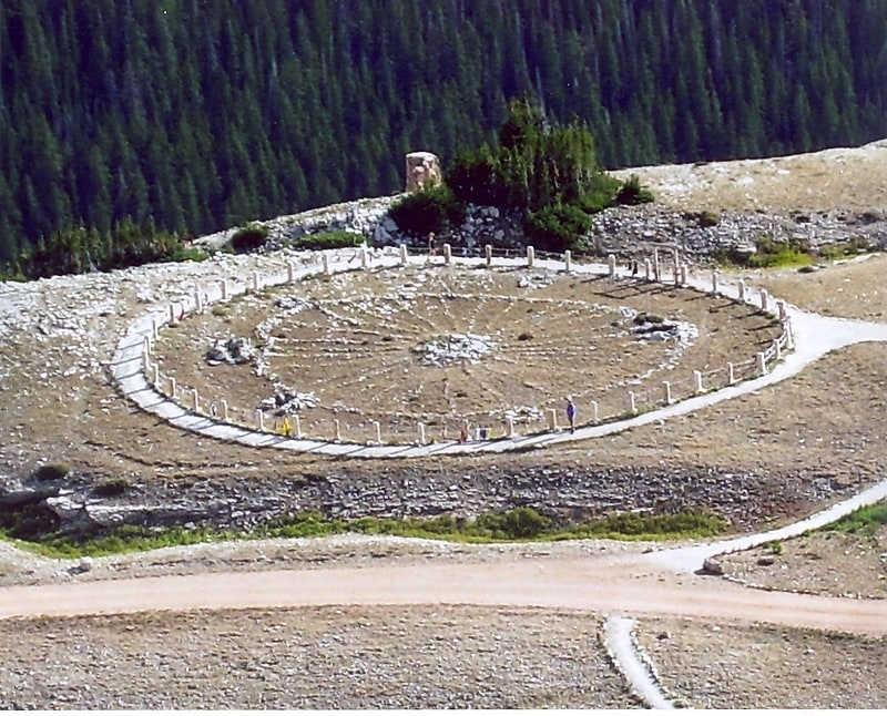
Medicine Wheel/Medicine Mountain National Historic Landmark

Historical landmark in the Big Horn County, Wyoming. The Medicine Wheel/Medicine Mountain National Historic Landmark is a medicine wheel located in the Bighorn National Forest, in the U.S. state of Wyoming. The Medicine Wheel at Medicine Mountain is a large stone structure made of local white limestone laid upon a bedrock of limestone. It is both a place of sacred ceremony and scientific inquiry. In Native Science these uses are not distinguished as separate as they are in Western science.
The cultural history of the Big Horn Mountains, home to the Big Horn Medicine Wheel, dates back over ten thousand years.[3]
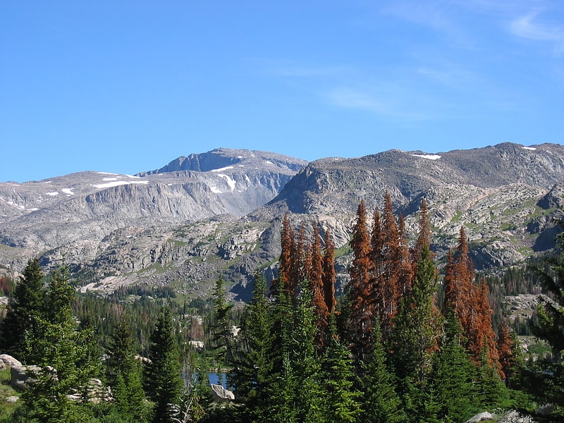
Cloud Peak
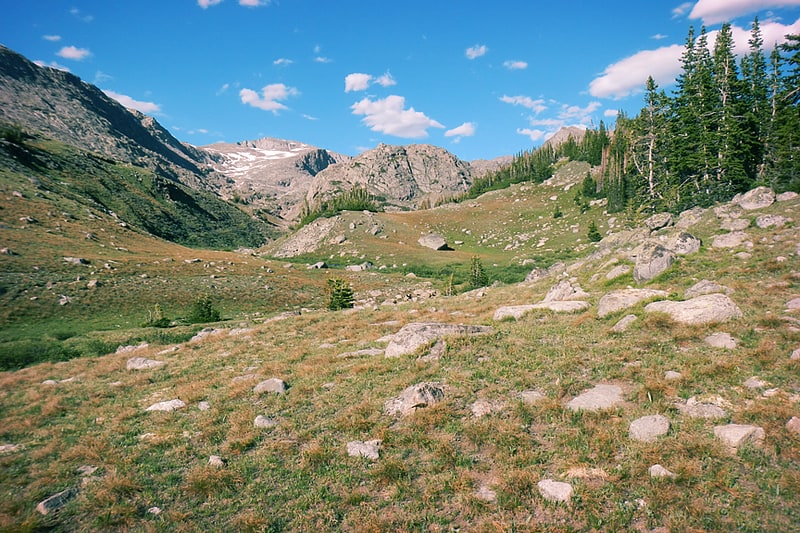
Peak in Wyoming. Cloud Peak is the highest peak within the Bighorn Mountains in the U.S. state of Wyoming. It rises to an elevation of 13,171 feet and provides onlookers with dramatic views and vistas. The mountain can be climbed most easily from the western side, accessed by either the Battle Park or West Tensleep trail-heads and is roughly 24 miles round-trip from both. The peak is located in the 189,000 acre Cloud Peak Wilderness within Bighorn National Forest. The northeast slope of Cloud Peak is a deep cirque which harbors Cloud Peak Glacier, the last active glacier in the Bighorn Mountains.
Cloud Peak is on the border between Johnson County and Big Horn County in Wyoming and is the high point of both counties. As the high point of an isolated range, Cloud Peak has the greatest topographic prominence in the state, 7,077 feet (2,157 m), one foot more than the state's highest mountain, 13,810 foot (4,210 m) Gannett Peak, and fifteenth greatest in the contiguous United States.[4]
Tongue River Cave
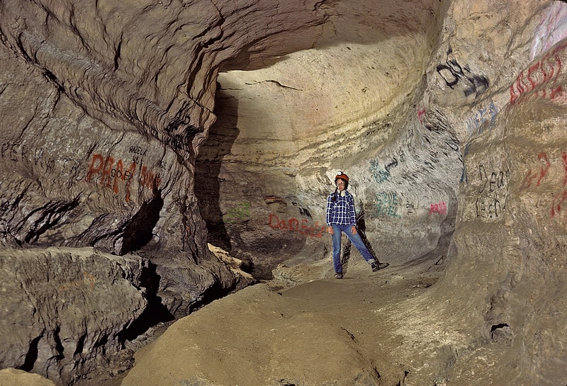
Cave. Tongue River Cave is a cave in the Bighorn National Forest just west of Dayton, Wyoming. Historically notable for a wide variety of rare cave formations and animal species, the cave has suffered in recent decades from unrestricted traffic, vandalism, and the theft of many of the cave's speleothems. Deemed beyond preservation, the cave is now managed by the U.S. Forest Service as a "sacrifice cave".
The Big Horn National Forest closed the cave to the public in July, 2010 to prevent the spread of White nose syndrome, however the cave has since been reopened. Registration and decontamination of clothing and gear is now required to visit the cave per Forest Order.[5]
James T. Saban Lookout
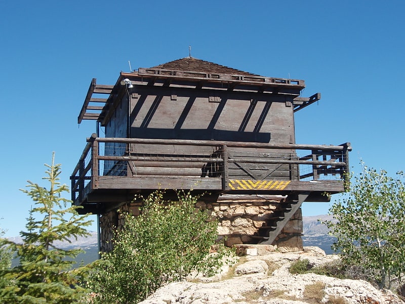
Vista point in Washakie County, Wyoming. The James T. Saban Lookout, also known as the High Park Lookout, is a fire lookout tower located in Bighorn National Forest near Ten Sleep, Wyoming in Washakie County, Wyoming. It was listed on the National Register of Historic Places in 2016.[6]
Bomber Mountain
Ridge in Wyoming. Bomber Mountain is the crest of a ridge line within the Bighorn Mountains of the U.S. State of Wyoming. It borders the south side of Cloud Peak, the tallest peak in the range. It is about 23 miles west of Buffalo. A military aviation accident that occurred upon the mountain in 1943 led to it being named Bomber Mountain in 1946. For more info see, "The Bomber Mountain Crash: A Wyoming Mystery" by Scott Madsen, Published and Copyrighted in September, 1990[7]
Powder River Pass
Mountain pass in Wyoming. Powder River Pass is a mountain pass in the Bighorn Mountains in Wyoming traversed by U.S. Highway 16. Also known as Muddy Pass, it is the highest point on Highway 16. It is between the towns of Buffalo and Ten Sleep.[8]
Black Tooth Mountain
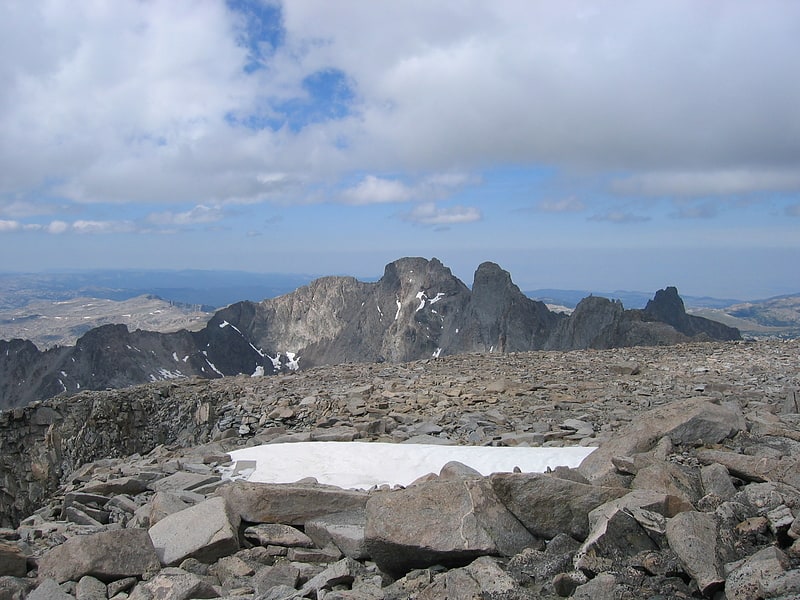
Mountain in Wyoming. Black Tooth Mountain is located in the Bighorn Mountains in the U.S. state of Wyoming. The peak is the second highest in the range after Cloud Peak, which is only 1.5 miles to the south, and the summit is located in the Cloud Peak Wilderness of Bighorn National Forest. The sharp dark profile of the mountain resembles a dark tooth or fang, hence the name. Because of the steep terrain, Black Tooth Mountain is one of the hardest mountains to climb in the Bighorns. Many of the trails up the mountain are unmarked which adds to the difficulty of reaching the summit. Mount Woolsey is an adjacent summit only.20 mi to the southeast. Another high peak of the Bighorns known as Hallelujah Peak is situated along a knife-like ridge known as an arête.64 mi to the northeast. Several tiny remnant glaciers can be found on the north slopes of Black Tooth Mountain.[9]
Mount Woolsey

Mountain in Wyoming. Mount Woolsey is located in the Bighorn Mountains in the U.S. state of Wyoming. The peak is the third highest in the range after Cloud Peak, which is only 1.3 miles to the south, and the summit is located in the Cloud Peak Wilderness of Bighorn National Forest. Black Tooth Mountain, the second highest mountain in the Bighorns, is an adjacent summit only.20 mi to the northwest. Mount Woolsey is on a knife-like ridge known as an arête and is connected to both Black Tooth Mountain and Cloud Peak by this ridge. Along the arête is another mountain peak known as The Innominate. A small glacier lies below the arête to the southeast of Mount Woolsey.[10]
Hallelujah Peak

Mountain in Wyoming. Hallelujah Peak, also known as Peak 12590, is located in the Bighorn Mountains in the U.S. state of Wyoming. The peak is the fifth-highest in the range and it is in the Cloud Peak Wilderness of Bighorn National Forest. Hallelujah Peak is 0.64 miles northeast of Black Tooth Mountain and connected to that peak by a knife-like ridge known as an arête.[11]