Discover 11 hidden attractions, cool sights, and unusual things to do in Tonto National Forest (United States). Don't miss out on these must-see attractions: Theodore Roosevelt Dam, Theodore Roosevelt Lake, and Picketpost Mountain. Also, be sure to include Pinal Mountains in your itinerary.
Below, you can find the list of the most amazing places you should visit in Tonto National Forest (Arizona).
Table of Contents
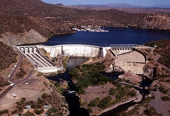
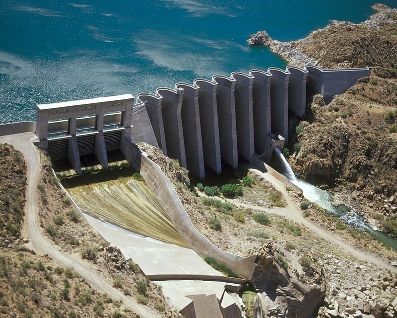
Theodore Roosevelt Dam
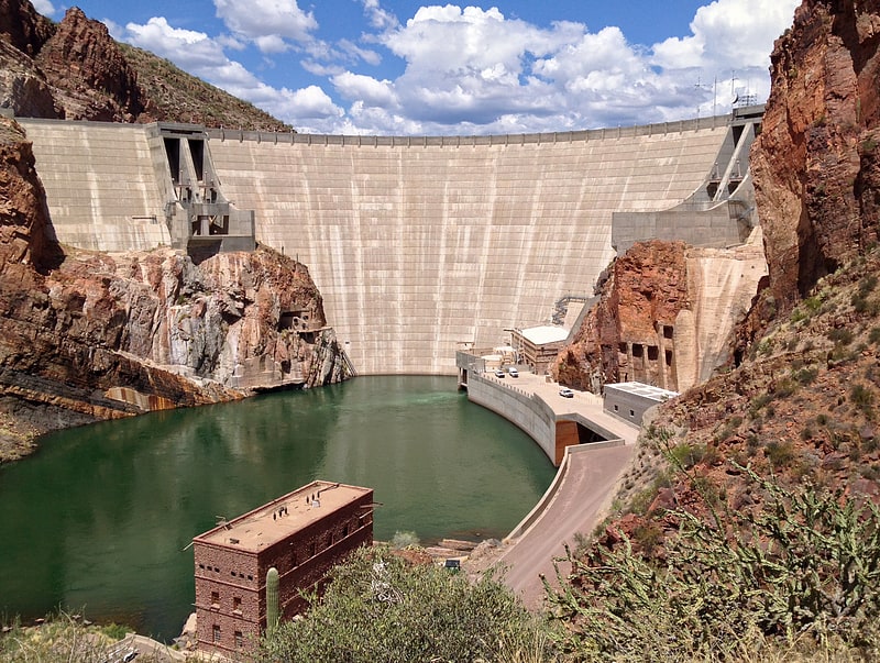
Historical landmark in Roosevelt, Arizona. Theodore Roosevelt Dam is a dam on the Salt River located northeast of Phoenix, Arizona. The dam is 357 feet high and forms Theodore Roosevelt Lake as it impounds the Salt River. Originally built between 1905 and 1911, the dam was renovated and expanded in 1989–1996. The dam is named after President Theodore Roosevelt. Serving mainly for irrigation, water supply, and flood control, the dam also has a hydroelectric generating capacity of 36 megawatts.[1]
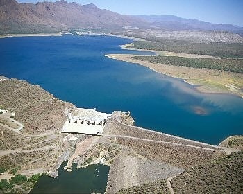
Theodore Roosevelt Lake
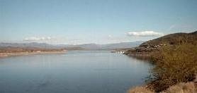
Reservoir in Arizona. Theodore Roosevelt Lake is a large reservoir formed by Theodore Roosevelt Dam on the Salt River in Arizona as part of the Salt River Project. Located roughly 80 miles northeast of Phoenix in the Salt River Valley, Theodore Roosevelt is the largest lake or reservoir located entirely within the state of Arizona. The reservoir and the masonry dam that created it, Roosevelt Dam, were both named after U.S. President Theodore Roosevelt who dedicated the dam himself in March 1911. Roosevelt Lake is a popular recreation destination within the Tonto National Forest; the facilities located at this lake are managed by that authority.
Roosevelt Lake is the oldest of the six reservoirs constructed and operated by the Salt River Project. It also has the largest storage capacity of the SRP lakes with the ability to store 1,653,043 acre-feet (2.039 km3) of water when the conservation limit of Roosevelt Dam is reached. When the dam is in flood-control mode, the lake can store 2,910,200 acre⋅ft (3.590 km3) of water; however, the U.S. Army Corps of Engineers requires all water over the conservation limit to be released from the lake within 20 days.[2]
Picketpost Mountain
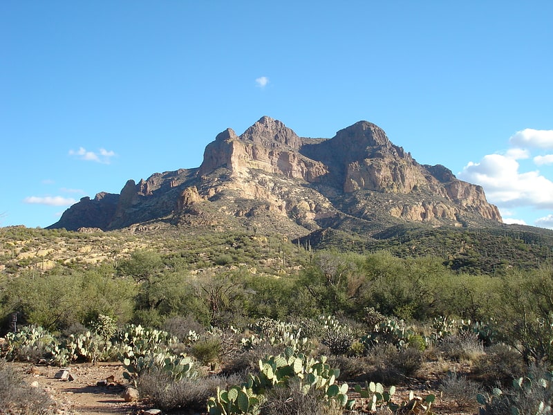
Mountain in Arizona. Picketpost Mountain is located just outside the town of Superior, Arizona approximately 40 miles east of the Phoenix Metro Area. The mountain is located in the southern desert region of Tonto National Forest near the Superstition Mountains, and is popular with hikers. The mountain is also well known for an oddly placed mailbox at the top of the mountain, which contains the log books for the Picketpost Mountain Trail.
The mountain's unusual name stems from an early military camp established at the base of the mountain by General George Stoneman in 1870. The soldiers nicknamed the mountain “Picket Post” due to its usage as a sentinel point to guard their camp from attacks. This military camp eventually grew into the present day town of Superior.[3]
Pinal Mountains
Mountain range in Arizona. The Pinal Mountains are a mountain range located in Gila County, Arizona. They have a maximum elevation of 7,848 ft at Pinal Peak and a prominence of over 4,000 ft. The closest city is the Globe, Arizona/Miami, Arizona area, which is just a few miles north of the mountain range. The mountains are located within the Tonto National Forest, and their recreational facilities are maintained by the USDA's United States Forest Service. The San Carlos Indian Reservation is very close to the mountain range, with its boundaries being just a few miles east/northeast of the range. The mountains are covered with Ponderosa Pine and white fir and experience cooler weather than the Globe/Miami area, so that they are a popular recreation area in the summer. The maintained facilities include a maintained dirt road that goes all the way to the summit of Pinal Peak, a campsite and recreational area, many hiking trails, as well as some radio towers near both Pinal and Signal peaks. The mountain range covers an area of 45,760 acres.[4]
Pinal Peak
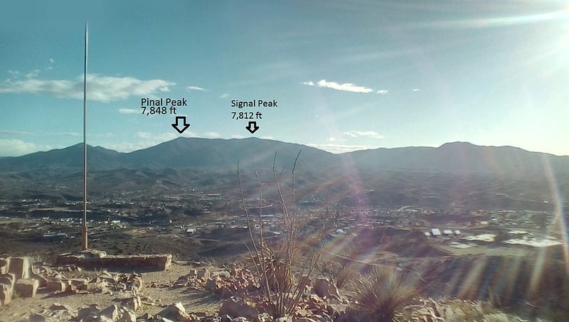
Peak in Arizona. Pinal Peak, located in southern Gila County, Arizona, is the highest point in the Pinal Mountains, with an elevation of 7,848 feet. It is the highest point of land located in between the Salt and Gila rivers in Arizona before they merge, making it visible from miles away on a clear day. The peak ranks as the 11th most prominent in Arizona and has a topographic isolation of 35 miles, with the nearest point of land of equal or greater elevation being to the southeast in the Santa Teresa Mountains. Pinal Peak is slightly east of the approximate center of the Pinal Mountains. Despite being the most prominent peak in Gila County, it is not the highest point in the county. That title goes to Myrtle Point with an elevation between 7,963 and 8,003 feet, which lies atop the edge of the Mogollon Rim which forms the county line with Coconino County. The nearest population is in the Globe/Miami, Arizona area, just a few miles north of the range and peak.[5]
Stewart Mountain Dam
The Stewart Mountain Dam is a concrete thin arch dam located 41 miles northeast of Phoenix, Arizona. The dam is 1,260 feet long, 207 feet high, and was built between 1928 and 1930. The dam includes a 13,000 kilowatt hydroelectric generating unit that is operated by SRP, an Arizona public utility. It is primarily operated during the summer months. The dam forms Saguaro Lake as it slows the passage of the Salt River in Maricopa County, Arizona. It was named after a ranch that used to be located nearby known as the Old Stewart Ranch.
A camp was built just below the dam in 1927 to house the construction workers; after the damn's completion it was turned into the Saguaro Lake Guest Ranch.
The dam was listed on the National Register of Historic Places in 2017.[6]
Bartlett Dam
Dam in Maricopa County, Arizona. The Bartlett Dam is a concrete multiple-arch buttress dam on the Verde River, located 50 km northeast of Phoenix, Arizona. The dam creates Bartlett Lake and its primary purpose is irrigation water supply. It was the first dam constructed on the Verde River and the first of its type constructed by the U.S. Bureau of Reclamation. It was built between 1936 and 1939. It was named after Bill Bartlett, a government surveyor. It was listed on the National Register of Historic Places in 2017.[7]
Address: Bartlett Road / FR 19, Tonto National Forest
Horseshoe Dam
The Horseshoe Dam is a dam located North of Phoenix, Arizona. The dam is 1,500 feet long, 144 feet high and was built between 1944–1946. The dam forms the Horseshoe Lake as it slows the passage of the Verde River. The dam was listed on the National Register of Historic Places in 2017.
Just below Horseshoe Dam is excellent fishing – popular spots include Catfish Point and Mesquite Cove.[8]
Mazatzal Mountains
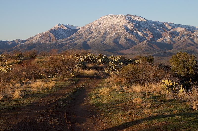
Mountain range in Arizona. The Mazatzal Mountains are a mountain range in south central Arizona, about 30–45 miles northeast of Phoenix and the Phoenix metropolitan area. The origin of the name remains obscure but one possibility is that it is from the Nahuatl language meaning "place of the deer". The crest of the Mazatzals forms the county line between Maricopa County and Gila County. SR 87, the Beeline Highway, traverses the Mazatzals on its way to Payson. The highest peak is Mazatzal Peak at 7,903 feet. They also include the Four Peaks, with elevation 7,659 ft, 2,334 m; a prominent mountain and landmark of the eastern Phoenix area.
The Mazatzal Wilderness Area protects 252,500 acres (1,022 km2) of the Tonto and Coconino National forests. Established in 1940 and expanded to its present size in 1984, elevations range from 2,100 feet (640 m) at Sheep Bridge in the southwest to 7,903 feet (2,409 m) on Mazatzal Peak.
The eastern side of the wilderness consists of brush- or pine-covered mountains, sometimes broken by narrow, vertical-walled canyons. On its west side below the steep brush-covered foothills, the Verde River flows through the Sonoran Desert. The Verde was designated by the U.S. Congress as one of Arizona's two Wild and Scenic Rivers in 1984.[9]
Sears-Kay Ruin
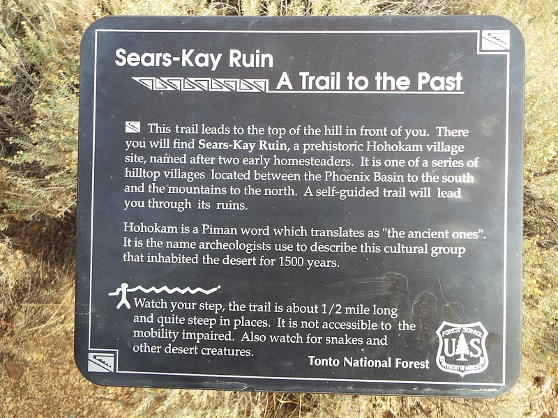
The Sears-Kay Ruin are the remains of what once was a fortification of the Hohokam culture. The ruins are located in the area of the Tonto National Forest just outside of the town of Carefree, Arizona. On November 24, 1995, it was listed in the National Register of Historic Places.[10]
Four Peaks
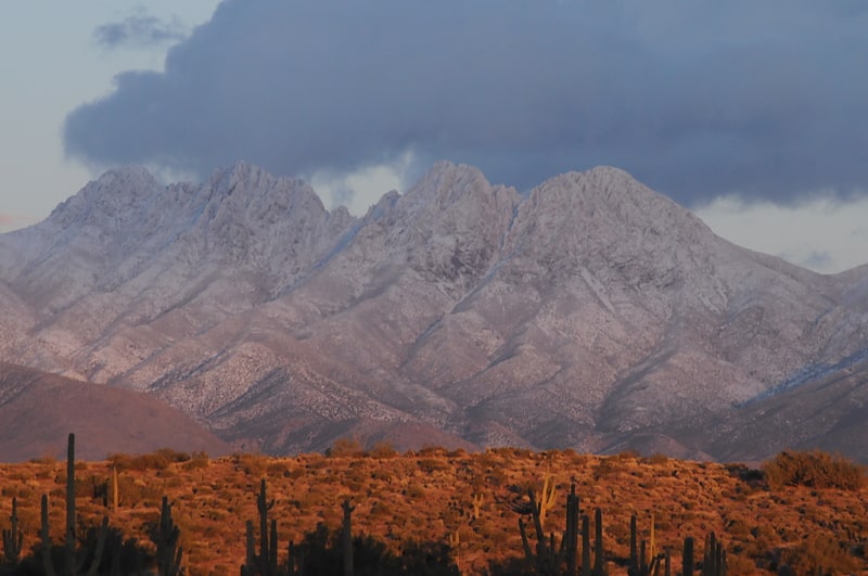
Mountain in Arizona. Four Peaks is a prominent landmark on the eastern skyline of Phoenix. Part of the Mazatzal Mountains, it is located in the Four Peaks Wilderness in the Tonto National Forest, 40 miles east-northeast of Phoenix. In winter, Four Peaks offers much of the Phoenix metro area a view of snow-covered peaks. Four Peaks is the site of an amethyst mine that produces top-grade amethyst.
The name Four Peaks is a reference to the four distinct peaks of a north–south ridge forming the massif's summit. The northernmost peak is named Brown's Peak and is the tallest of the four at 7,659 feet (2,334 m). It is the highest point in Maricopa County. The remaining summits are unnamed, and from north to south are 7,644 feet (2,330 m), 7,574 feet (2,309 m) and 7,526 feet (2,294 m) in elevation.[11]