Discover 11 hidden attractions, cool sights, and unusual things to do in Simi Valley (United States). Don't miss out on these must-see attractions: Reagan crypt, Fillmore and Western Railway, and Simi Adobe–Strathearn House. Also, be sure to include Grandma Prisbrey's Bottle Village in your itinerary.
Below, you can find the list of the most amazing places you should visit in Simi Valley (California).
Table of Contents
Reagan crypt
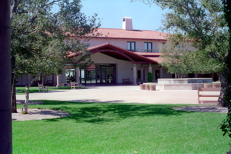
Archive in Ventura County, California. The Ronald Reagan Presidential Library is the repository of presidential records from the administration of Ronald Reagan, the 40th president of the United States, and the burial place of the president and first lady, Nancy Reagan. It is the largest of the 13 federally operated presidential libraries, containing millions of documents, photographs, films and tapes. There is a permanent exhibit covering Ronald Reagan's life, as well as memorabilia such as Air Force One, the aircraft personally used by the president, and a section of masonry from the Berlin Wall.
The library is located in Simi Valley, in Southern California, and was designed by Hugh Stubbins and Associates. It is administered by the National Archives and Records Administration (NARA).[1]
Address: 40 Presidential Dr, 93065-0600 Simi Valley
Fillmore and Western Railway
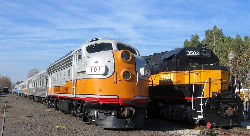
Railroad. The Fillmore and Western Railway is a railroad owned by the Fillmore and Western Railway Company. The company operated on track owned by the Ventura County Transportation Commission. Visitors to Fillmore would see filming activity as well as sets and support equipment at the company's rail yard and along the tracks between Santa Paula and Piru. They stopped operating on the line in 2021.[2]
Address: 351 Santa Clara Street, Simi Valley
Simi Adobe–Strathearn House
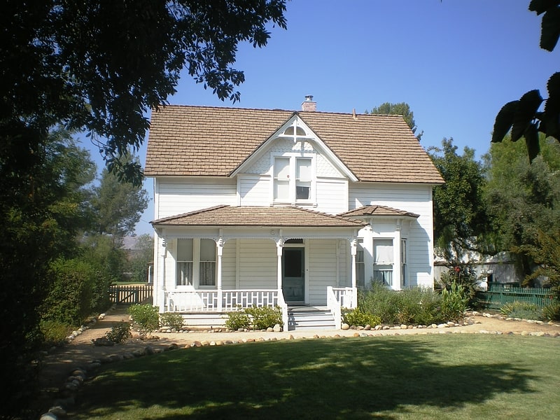
The historic Simi Adobe–Strathearn House served as the headquarters of Rancho Simi, also known as Rancho San José de Nuestra Senora de Altagracia y Simi, one of the land grants in Alta California by the Spanish government. The name derives from Shimiji, the name of the Chumash village here before the Spanish. Rancho Simi was the earliest Spanish colonial land grant within Ventura and Santa Barbara Counties. At 113,000 acres, Rancho Simi was one of the state's largest land grants.
The headquarters of the rancho served as the home of Robert P. Strathearn (and is thus known as the Strathearn House), built in 1892–93. The home remained in the Strathearn family until 1969, when the dwelling and 5.85 acres (2.37 ha) of surrounding land were donated to the Simi Valley Recreation and Park District. Two rooms of the original adobe remain as part of the Strathearn House, now located in Robert P. Strathearn Historical Park in Simi Valley, California. Rancho Simi has been designated a California Historical Landmark (#979) and is listed on the National Register of Historic Places.[3]
Address: 137 Strathearn Pl, 93065-1605 Simi Valley
Grandma Prisbrey's Bottle Village
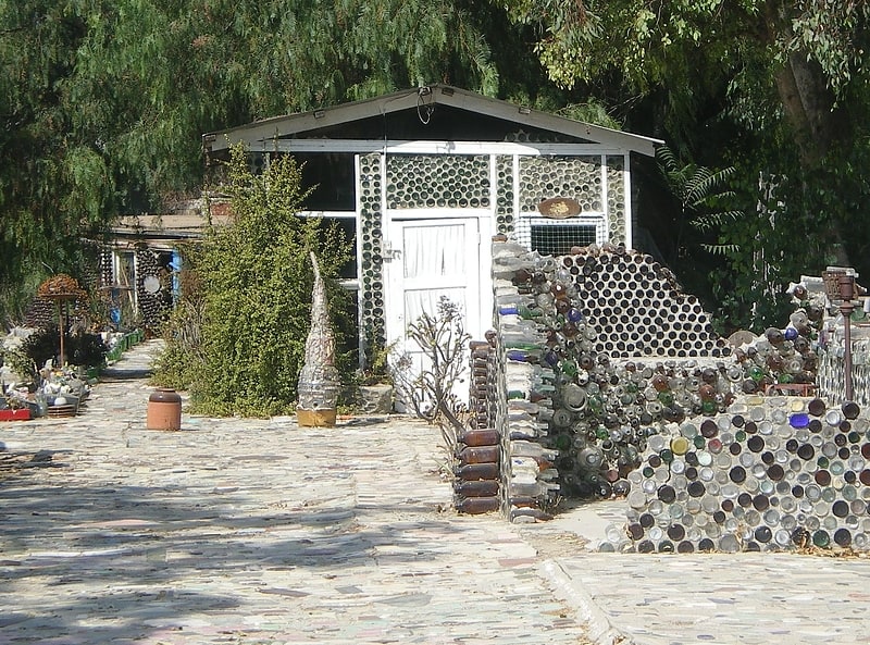
Historical landmark in Simi Valley, California. Grandma Prisbrey's Bottle Village, also known as Bottle Village, is an art environment, located in Simi Valley, California. It was created by Tressa "Grandma" Prisbrey from the 1950s to the 1970s. Prisbey built a "village" of shrines, walkways, sculptures, and buildings from recycled items and discards from the local landfill.
Bottle Village has been designated as a historical landmark by the City of Simi Valley, County of Ventura, and State of California (California Historical Landmark No. 939. It was also listed on the National Register of Historic Places in 1996.
Bottle Village closed in 1984 and was severely damaged during the 1994 Northridge earthquake.[4]
Address: 4595 Cochran St, Simi Valley
Santa Susana Depot
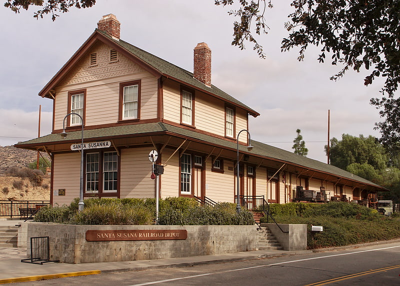
Santa Susana Depot is a train station building located near the Santa Susana Pass in Simi Valley, California. Originally located on Los Angeles Avenue at Tapo Street, the depot opened in 1903. The station was named after the Santa Susana Mountains at the east end of the Simi Valley. The Southern Pacific Railroad used the double-"N" spelling of Susanna on the depot sign facing west, and the single-"N" spelling of Susana on the sign facing east. The Santa Susana Tunnel opened the next year, reducing the distance and transit time between Montalvo and Burbank on the Coast Route linking Los Angeles and San Francisco. Plans and construction for the building were based on Southern Pacific Railroad standard design Two Story Combination Depot No. 22. The depot served the community of Rancho Simi as a passenger station, telegraph office, and freight depot where farmers could deliver crops for shipping and pick up farming equipment delivered by the railroad.
Due to lessening passenger traffic and changes in the shipment of freight, Southern Pacific closed the station in the early 1970s, leaving Santa Susana Depot empty and destined for demolition. The County of Ventura purchased the depot from the railroad for $1.06. In May 1975 the building was divided into three parts and moved by truck to county property two miles east of the site it was built on. The County of Ventura designated the building Landmark #29 in January, 1976.[5]
Mount McCoy
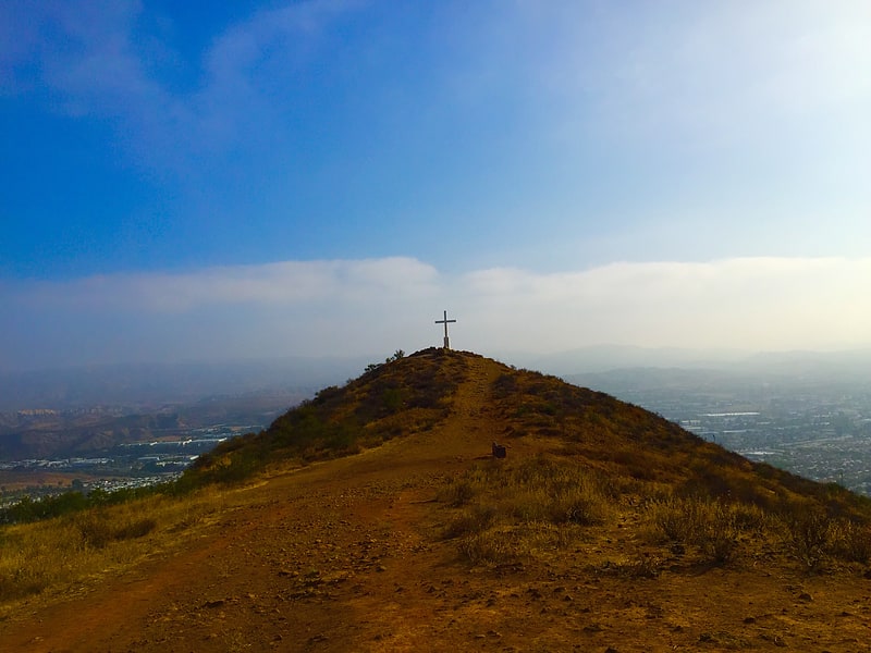
Peak. Mount McCoy is a 1,325-foot-high peak in Simi Valley, California known for its characteristic 12 foot white cross on the top. There are numerous trails leading to Mount McCoy, which sits in a 200 acres nature area operated by the Rancho Simi Recreation and Park District, while the cross and its immediate surroundings are owned by the Simi Valley Historical Society. By 1813, the cross on Mt. McCoy was a landmark for the Friars and others in the Simi Valley.
An 1858 map of the Simi Valley does show a cross on Mt. McCoy, but a newer cross was erected by Robert E. Harrington in 1921, and a concrete one later in 1941. Mount McCoy has been a landmark for the area since before the town was founded. In 1986, Mount McCoy was designated Ventura County Landmark No. 106. The main trailhead is located at 2 Washburn Street at the western end of Simi Valley. A trailhead to a shorter hiking trail is located around 56-58 Presidential Drive on the way to the Ronald Reagan Presidential Library. If you follow the off-road leading to the water tank on top of the hill, there is a side trail to the left leading you directly to the cross.
From the top of Mount McCoy there are views of the Simi Hills and Simi Valley, as well as Simi Peak, open-space areas and the Ronald Reagan Presidential Library. There are also views of the Santa Monica Mountains, Mount Baldy, the San Gabriel Mountains and the Topatopa Mountains, and on clear days, even the Ojai backcountry, the Channel Islands and the Pacific Ocean. It is one of two crosses overlooking the Simi Valley, the other one being situated by the Santa Susana Pass and Rocky Peak by the Santa Susana portion of eastern Simi Valley.[6]
Challenger Park
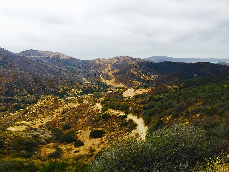
Challenger Park is a 141.55-acre open-space park located in southern portion of Simi Valley, California in the Simi Hills. The park is owned and maintained by the Rancho Simi Recreation and Park District. Challenger Park is used for mountain hiking, mountain biking, jogging, and horseback riding but with a focus on the preservation of wildlife habitat. The scenery lining the trails includes extensive oak woodlands, chaparral, and coastal sage scrub. The terrain varies greatly with rolling green hills and steep mountainous hills and canyons. The park offers miles of trails connecting to Long Canyon, Oak Canyon, Trough Canyon, Lone Oak Canyon, and other adjoining open-space nature areas in the southern section of the Simi Valley. There is a fairly easy hike to Thousand Oaks, CA via Long Canyon trails. To get to Oak Canyon, Old Windmill Park and Coyote Hills Park, you must cross Long Canyon Road. Fences run along the Long Canyon Road with dirt paths. There are also lights at the signals with push buttons for hikers, and raised buttons for equestrians. Adjacent to Challenger Park is also Bridle Trails, a private hiking area. There are scenic views of the City of Simi Valley from the park and it is a native habitat for numerous species of animals, including mule deer, mountain lions, coyotes, rattlesnakes, crawdads, California king-snakes, grey foxes, bobcats, as well as red-tailed hawks, barn owls, and numerous other raptors.
From California State Route 118, take the First Street exit in Simi Valley and continue south, turn right if coming from the west and turn left if from the east. Follow this road for 2.8 miles and then turn left into the Challenger Park parking lot, just past the intersection with Stonebrook. From California State Route 23, take the Olsen Road exit in Thousand Oaks, CA and go northeast for nearly 2 miles to Wood Ranch Parkway. Turn right on Wood Ranch and go approximately two miles to the junction with Long Canyon Road. Then turn left onto Long Canyon Road and follow the road for 1.7 miles. Challenger Park will be on the right, shortly before Long Canyon Road becomes First Street in South Simi Valley. The address is 105 Challenger Park Road, Simi Valley, CA 93065.[7]
Address: 3909 W 41st Pl, Simi Valley
Simi Valley Cultural Arts Center
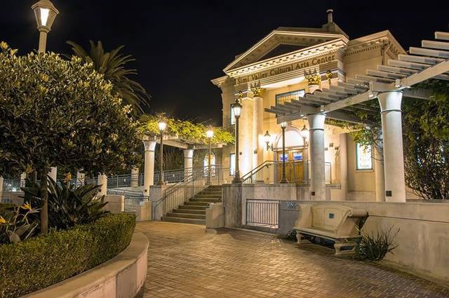
Museum, Theater, Concerts and shows, Art gallery
Address: 3050 E Los Angeles Ave, 93065-3939 Simi Valley
Oak Park
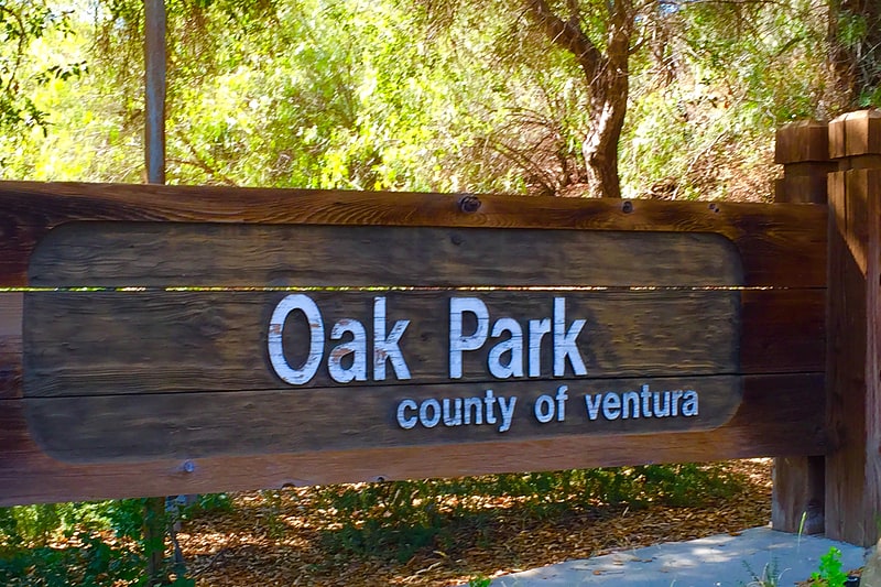
Regional park in Simi Valley, California. Oak Park is a 100.5-acre open space regional park located at 901 Quisma Drive in Simi Valley, California, near Moorpark and California State Route 118. This county park, maintained by the Santa Monica Mountains Conservancy, is situated in the foothill country surrounded by rolling hills in the extreme west Simi Valley. Oak Park is recognized for its many large oak trees, rolling hills, canyons, wildlife, and hiking trails through abundance of coastal scrub brush. The facilities offered are a playground, horseshoe pits, basketball court, picnic tables, restroom, dump station for RV’s, water fountain, BBQ, fire rings, as well as tent- and RV-camping. Oak Park is a reservation only park with a 2 night minimum. There are partial hookups and 30 amp service at 16 campsites in 2018 for tents or RV’s, a 16 space rv group camping area and one group tent site area for up to fifty people. There are 4 day use group areas, please call for reservations. There are occasionally summer programs in the camping site area. The park is home to various native flora and also wildlife, which consists of a wide range of Simi Valley native species such as numerous raptors, sagebrush lizards, alligator lizards, roadrunners, hummingbirds, grey foxes, bobcats, raccoons, opossums, skunks, and various snakes, including the Southern Pacific Rattlesnake and California Kingsnake. The park district is in the process of acquiring the 734-acre Alamos Canyon on the other side of West Los Angeles Avenue. A trail connecting Oak Park to the Alamos Canyon would be created and included within a greenbelt between the cities of Simi Valley and Moorpark.[8]
Skatelab
Museum in Simi Valley, California
Address: 4226 Valley Fair St, 93063-2941 Simi Valley
Tierra Rejada Park
Park in Simi Valley, California. Tierra Rejada Park is a 150-acre park located in the northern Simi Hills foothills, in southwestern Simi Valley city near Moorpark, in Ventura County, California.
There are several trails leaving from the park to: Moorpark; Mount McCoy, Oak Canyon, Coyote Hills Park, Long Canyon, Wood Ranch Open Space, and other open-space nature areas in southwestern Simi Valley. Trails up into the Simi Hills, offer panoramic views of the Simi Valley, the Santa Rosa Valley, eastern Moorpark, and the western Santa Susana Mountains.
The main Tierra Rejada Trailhead is adjacent to the Arroyo Simi wash, and the city is planning trailheads from the park along the new Arroyo Simi Greenway along the creek.[9]