Discover 11 hidden attractions, cool sights, and unusual things to do in Fremont (United States). Don't miss out on these must-see attractions: NewPark Mall, Ardenwood Historic Farm, and Niles Canyon. Also, be sure to include Coyote Hills Regional Park in your itinerary.
Below, you can find the list of the most amazing places you should visit in Fremont (California).
Table of Contents
NewPark Mall
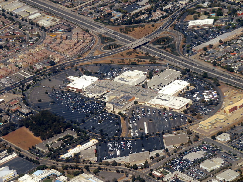
Mall in Newark, California. NewPark Mall is a 1,161,681 square feet super-regional mall in Newark, California. Opened in August 1980, it currently houses 119 stores. It serves the Tri-City area. The mall underwent extensive renovations that were completed in early 2017. Among the additions are a 12-screen AMC movie complex with an IMAX screen and an elaborate new glass-walled restaurant area with views through the entire property.
The Marin Farmers Markets nonprofit organization operates a farmers market on the mall property on Sunday. The mall is adjacent to the Newark campus of Ohlone College and Newark Memorial High School.[1]
Address: Fremont, 2086 NewPark Mall
Ardenwood Historic Farm
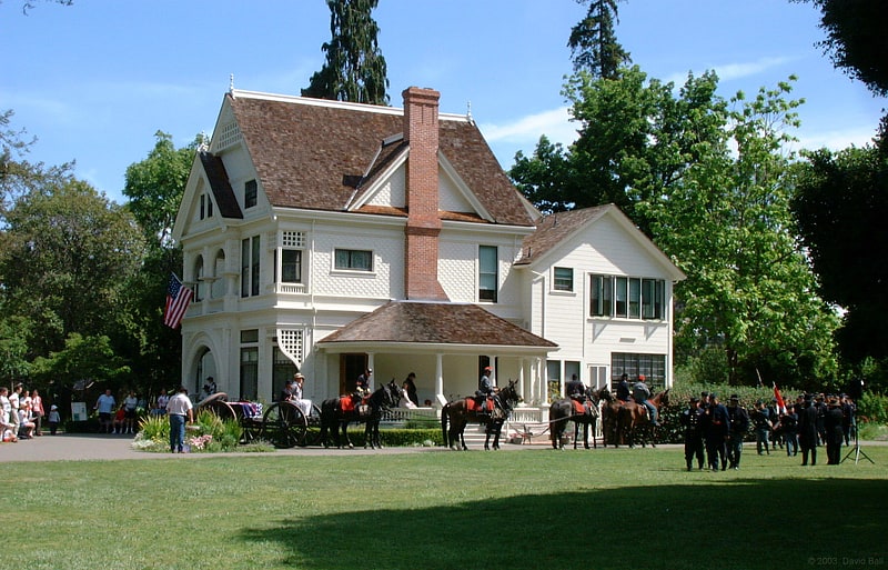
Regional park in Fremont, California. Ardenwood Historic Farm is a Regional Historic Landmark in Fremont, California. It is managed by the East Bay Regional Park District. The Ardenwood Historic Farm consists of the Ardenwood Station, the former Ohlone village and burial site, a blacksmith shop, an area with farm animals, Patterson House, and a gazebo. The Ardenwood Farm today is a working farm, producing grain and vegetables.[2]
Address: 34600 Ardenwood Blvd, 94555-3645 Fremont (North Fremont)
Niles Canyon
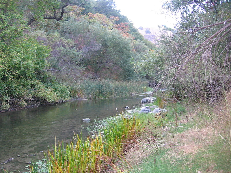
Niles Canyon is a canyon in the San Francisco Bay Area formed by Alameda Creek, known for its heritage railroad and silent movie history. The canyon is largely in an unincorporated area of Alameda County, while the western portion of the canyon lies within the city limits of Fremont and Union City. The stretch of State Route 84 known as Niles Canyon Road traverses the length of the canyon from the Niles district of Fremont to the unincorporated town of Sunol. Two railroads also follow the same route down the canyon from Sunol to Niles: the old Southern Pacific track along the north side, now the Niles Canyon Railway, and the newer Union Pacific track a little to the south. At the west end of the canyon are the ruins of the Vallejo Flour Mill, which dates to 1853.[3]
Coyote Hills Regional Park
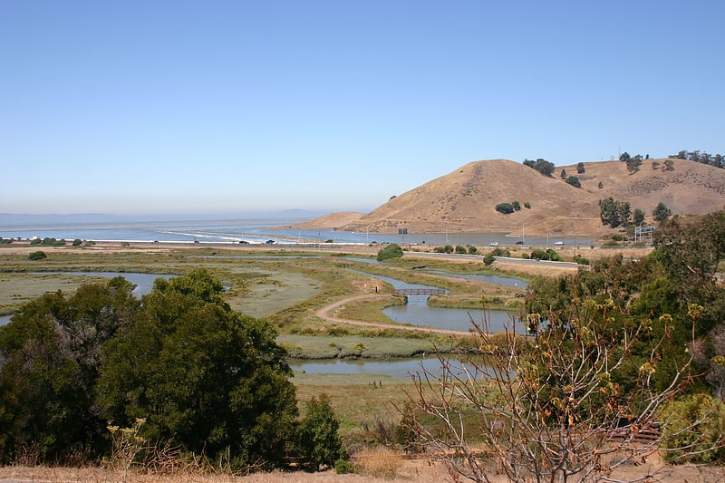
Regional park in Fremont, California. Coyote Hills Regional Park is a regional park encompassing nearly 978 acres of land and administered by the East Bay Regional Park District. The park, which was dedicated to public use in 1967, is located in Fremont, California, USA, on the southeast shore of the San Francisco Bay. The Coyote Hills themselves are a small range of hills at the edge of the bay; though not reaching any great height, they afford tremendous views of the bay, three of the trans-bay bridges, the cities of San Francisco and Oakland, the Peninsula Range of the Santa Cruz Mountains and Mount Tamalpais. In addition to the hills themselves, the park encloses a substantial area of wetlands.
There are a number of archaeological sites within the park, preserving evidence of habitation by Native Americans of the Ohlone group of tribes, including shellmounds. Access to these sites is not allowed for casual visitors, but they can be visited by arrangement.
There is a substantial network of hiking trails in the park, most of them also available to equestrians, and 3.5 miles (5.6 km) to cyclists. Most of the trails are wide fireroads that go around the hills and the marshes, and one fireroad that runs north-south through the hills ridge. There are few narrow trails which are off limits to bikers and equestrians. These trails connect to others in the east bay, and the San Francisco Bay Trail passes through the park. Cross country meets for local schools are held occasionally in the park. The waters to the south and west of the park form part of the San Francisco Bay National Wildlife Refuge, and a great deal of wildlife can be seen from the park trails.[4]
Address: 8000 Patterson Ranch Rd, 94555 Fremont
Mission San José
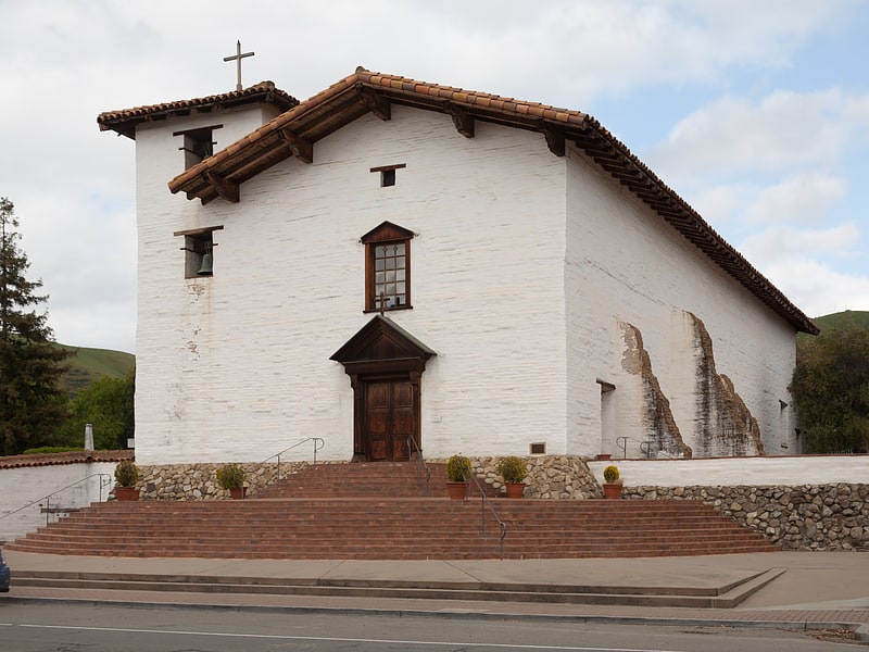
Museum in Fremont, California. Mission San José is a Spanish mission located in the present-day city of Fremont, California. It was founded on June 11, 1797, by the Franciscan order and was the fourteenth Spanish mission established in California. The mission is the namesake of the Mission San José district of Fremont, which was an independent town subsumed into the city when it was incorporated in 1957. The Mission entered a long period of gradual decline after Mexican secularization act of 1833. After suffering decline, neglect and earthquakes most of the mission was in ruins. Restoration efforts in the intervening periods have reconstructed many of the original structures. The old mission church remains in use as a chapel of Saint Joseph Catholic Church, a parish of the Diocese of Oakland. The museum also features a visitor center, museum, and slide show telling the history of the mission.[5]
Address: 43300 Mission Blvd, 94539-5829 Fremont
Mission Peak
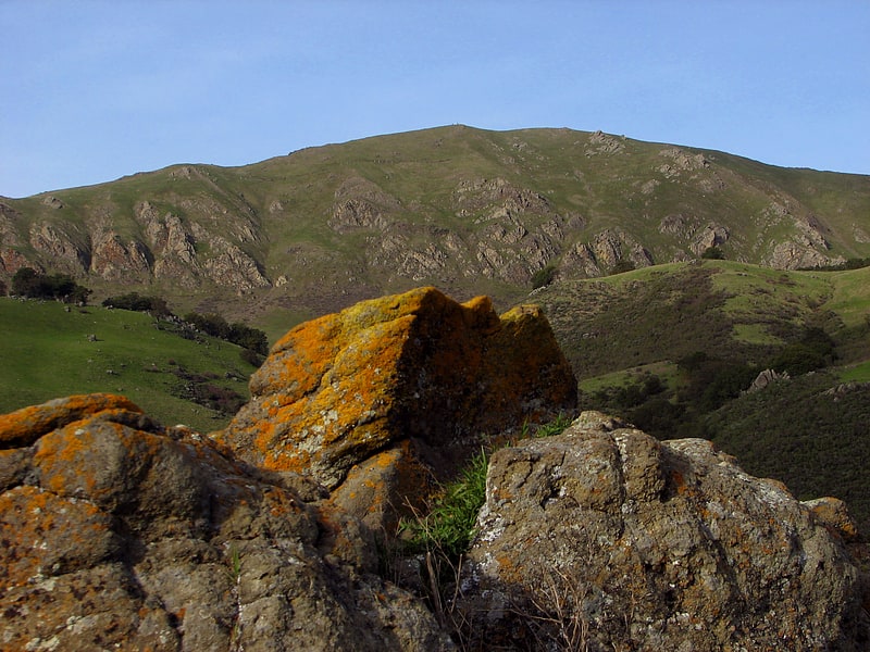
Mountain in California. Mission Peak is a mountain peak located east of Fremont, California. It is the northern summit on a ridge that includes Mount Allison and Monument Peak. Mission Peak has symbolic importance, and is depicted on the logo of the City of Fremont. It is located in Mission Peak Regional Preserve, a regional park operated by the East Bay Regional Park District.[6]
Lake Elizabeth
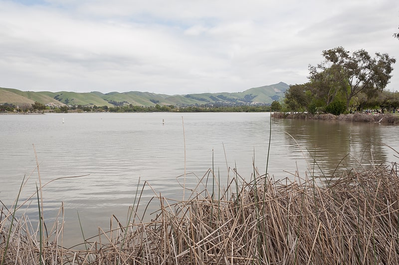
Lake in California. Lake Elizabeth, located in Central Park of Fremont, California, is a man made 83-acre lake with a 2 mile walkway around the lake. When at average capacity, water rises to a depth of about seven feet.[7]
Address: 40000 Paseo Padre Pkwy, 94538 Fremont
Fremont Central Park
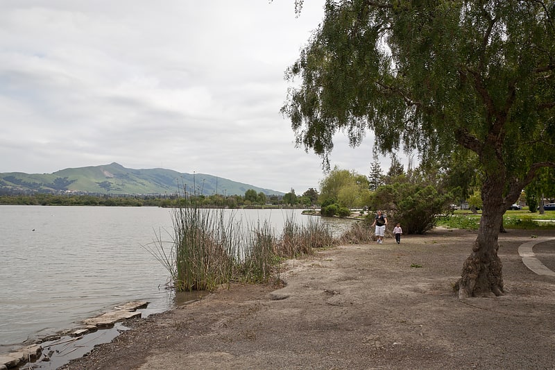
Park in Fremont, California. Fremont Central Park is a 450-acre park in the central area of Fremont, California on Paseo Padre Parkway at Stevenson Boulevard. It is easily accessible from I-880 and I-680. It began development in 1960, and contains Lake Elizabeth, a shallow 83-acre man made lake surrounded by picnic areas, sports fields, and walking and biking paths. The lake was dedicated to Fremont's sister city, Elizabeth, South Australia in 1969. A nine-hole golf course and driving range is northeast of the park, while a skateboarding park and water slide swimming facility are southwest.
Much of the park was once the Stivers Lagoon and is part of the Laguna Creek Watershed.[8]
Address: 40000 Paseo Padre Parkway, Fremont
Quarry Lakes Regional Recreation Area
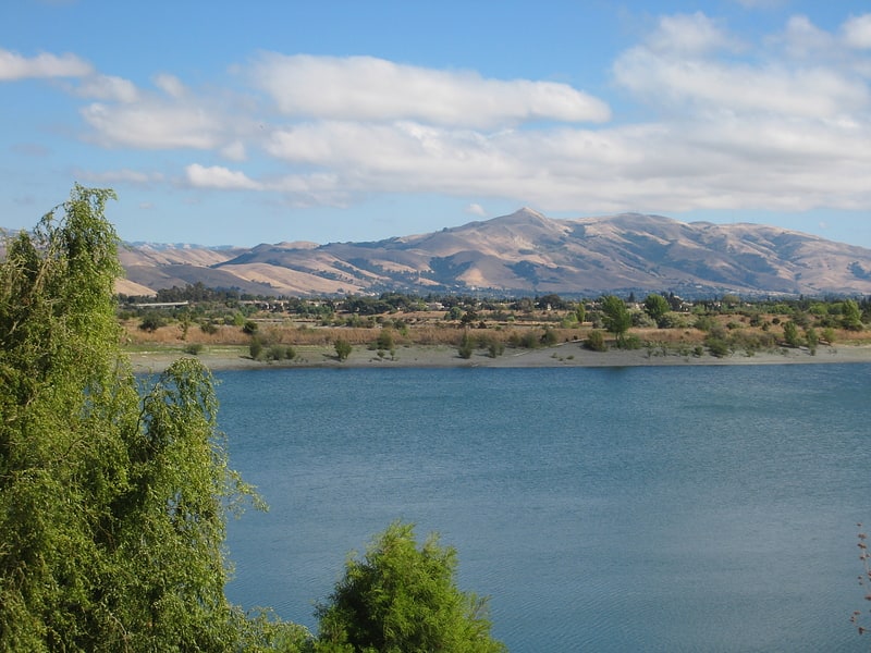
Regional park in Fremont, California. Quarry Lakes Regional Recreation Area is a regional park located in Fremont, California that is part of the East Bay Regional Parks system. Before being converted into a park, the site was used as a gravel quarry. When water purchased by the public for groundwater recharge of the Niles Cone flooded the gravel pits, the gravel harvesters began to daily pump the seeping water down Alameda Creek into San Francisco Bay. The Alameda County Water District acquired the quarry after the pumping was declared to be an illegal waste in 1976.
The Park is located roughly between Centerville and Niles. It is bounded to the northeast by the train tracks of the BART system, and to the south and west by Alameda Creek.[9]
Centerville Pioneer Cemetery
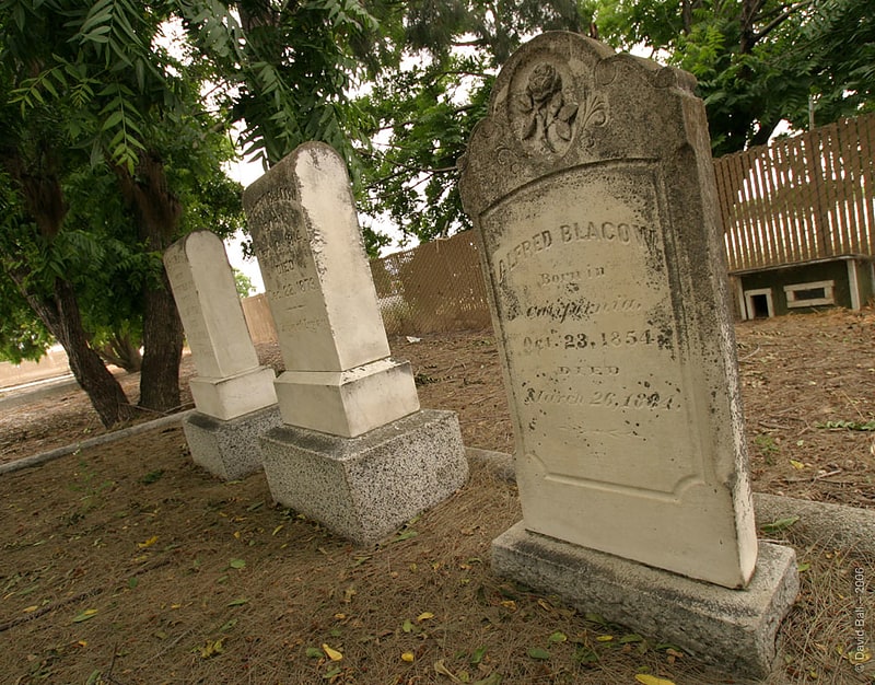
Cemetery in Fremont, California. The Centerville Pioneer Cemetery, also known as the Centerville Presbyterian Cemetery or Alameda Presbyterian Cemetery, is located at the corner of Post Street and Bonde Way in Fremont, California. It was officially designated as a state cemetery in 1858 or 1859, depending upon the source, and was listed in the California Register of Historic Resources in 1976.[10]
Niles Essanay Silent Film Museum
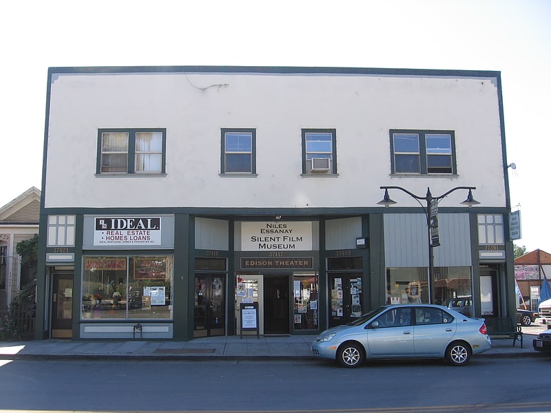
Museum in Fremont, California. The Niles Essanay Silent Film Museum is located in what is now the historic district of Niles in the city of Fremont, CA. The museum is housed in the Edison Theater, a century-old Nickelodeon movie theater, just half a block from the former site of the Niles Essanay Studios where Broncho Billy and Charlie Chaplin made films in the 1910s. It is dedicated to preserving and showing silent films and their history. The silent film historical work of one of the members of its staff, David Kiehn, was featured on 60 Minutes for demonstrating that a film shot in San Francisco titled A Trip Down Market Street was actually made a few days before the 1906 San Francisco earthquake. Additionally, when Google made a Google Doodle for April 16, 2011, in celebration of Chaplin's 122nd birthday, they collaborated with the Niles Silent Film Museum to produce the short.
The museum houses a large collection of Motion Picture equipment and related artifacts, as well as about 10,000 Silent Films in their archive.[11]
Address: 37417 Niles Blvd, 94536-2949 Fremont