Discover 11 hidden attractions, cool sights, and unusual things to do in Blue Mountains National Park (Australia). Don't miss out on these must-see attractions: Three Sisters, Evans Lookout, and Ruined Castle. Also, be sure to include Mount Banks in your itinerary.
Below, you can find the list of the most amazing places you should visit in Blue Mountains National Park (New South Wales).
Table of Contents
Three Sisters
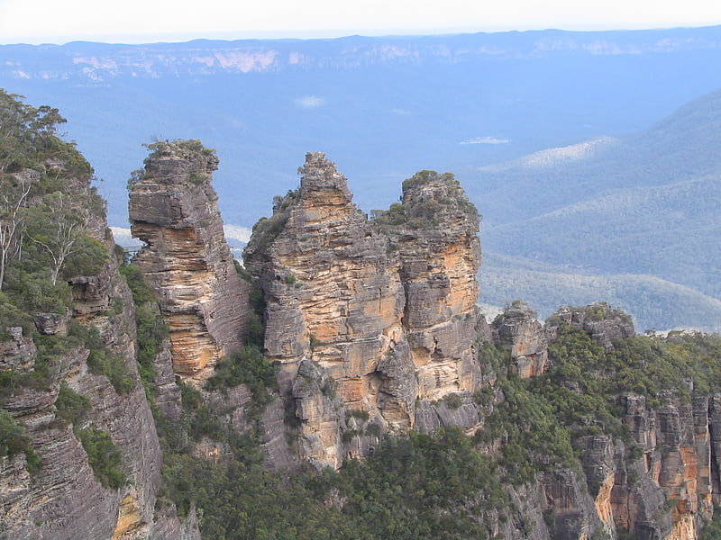
Lookout point for iconic trio of rocks. The Three Sisters are an unusual rock formation in the Blue Mountains of New South Wales, Australia, on the north escarpment of the Jamison Valley. They are located close to the town of Katoomba and are one of the Blue Mountains' best known sites, towering above the Jamison Valley. Their names are Meehni, Wimlah, and Gunnedoo.[1]
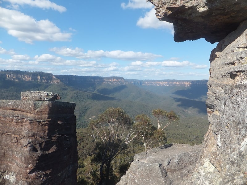
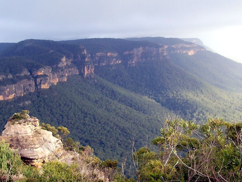
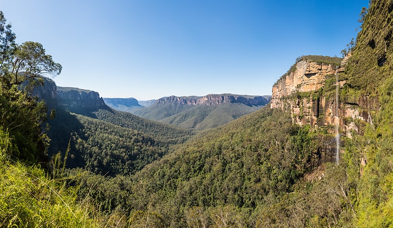
Evans Lookout
Vista point in Blue Mountains National Park, Australia. Evans Lookout is a lookout in the Blue Mountains, New South Wales, Australia. Overlooking the sandstone cliffs of the Grose River Valley, the lookout is also an access point for pedestrian access to the valley floor.
Nearby walks include the Grand Canyon and trails to Govetts Leap lookout.
A popular, easily accessible location, the lookout is located within the Blue Mountains National Park close to the town of Blackheath.[2]
Address: Evans Lookout Rd, 2785 Blackheath
Ruined Castle
Tourist attraction in Australia. The Ruined Castle is a rock formation in the Jamison Valley area of the Blue Mountains, in New South Wales, Australia. There are campsites nearby and this site can be visited as part of a multi-day hiking expedition. From the top of the Ruined Castle amazing 360 degree views can be seen over the Jamison Valley and the surrounding Blue Mountains[3]
Mount Banks
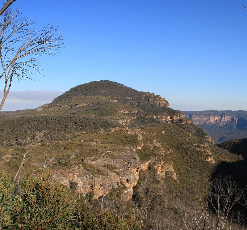
Mount in Australia. Mount Banks, a mountain within the Explorers Range of the Blue Mountains Range that is a spur off the Great Dividing Range, is located within the Blue Mountains National Park, approximately 100 kilometres west of Sydney in New South Wales, Australia. Mount Banks is located 8 kilometres from the nearest residential area, Mount Tomah, has an elevation of 1,049 metres AMSL, and can be accessed relatively easily via the Bells Line of Road.[4]
Perrys Lookdown
Perry's Lookdown is situated on the edge of the Grose Valley in the Blue Mountains, Australia. It is believed to have been named by Frederick Eccleston Du Faur after either Samuel Augustus Perry or a local innkeeper. Free campsites are adjacent to the car park. The Blue Gum Forest is often accessed by foot from here, 656 vertical metres below the lookdown. The road to Blackheath is unsealed.[5]
Lake Burragorang
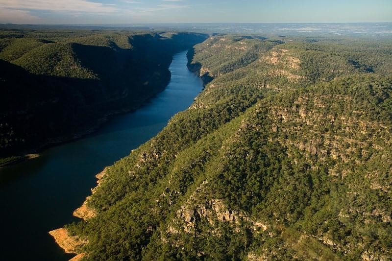
Reservoir in Australia. Lake Burragorang is a man-made reservoir in the lower Blue Mountains of New South Wales, Australia, serving as a major water supply for greater metropolitan Sydney. The dam impounding the lake, the Warragamba Dam, is located approximately 60 kilometres southwest of the Sydney central business district.
Lake Burragorang is within the World Heritage Site of the Greater Blue Mountains Area. The 2,031-gigalitre (4.47×10¹¹ imp gal; 5.37×10¹¹ US gal) reservoir collects water from the converged flows of the Coxs, Kowmung, Nattai, Wingecarribee, Wollondilly, and Warragamba rivers and their associated tributaries, all within the Nepean and Hawkesbury River catchment.[6]
Mount Hay
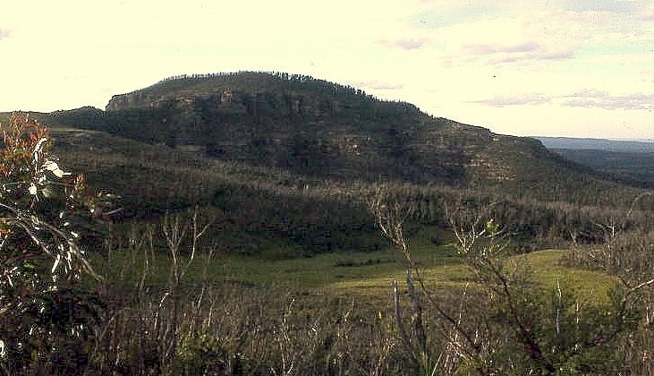
Mountain in Australia. Mount Hay, a mountain that is part of the Mt Hay Range of the Blue Mountains Range which is a spur off the Great Dividing Range, is located in the Blue Mountains National Park, New South Wales, Australia. It is located approximately 100 kilometres west of Sydney and 10 kilometres north of the nearest town, Wentworth Falls. Mount Hay is approximately 944 metres AMSL and is one of several basalt caps located within the UNESCO World Heritage Greater Blue Mountains Area.[7]
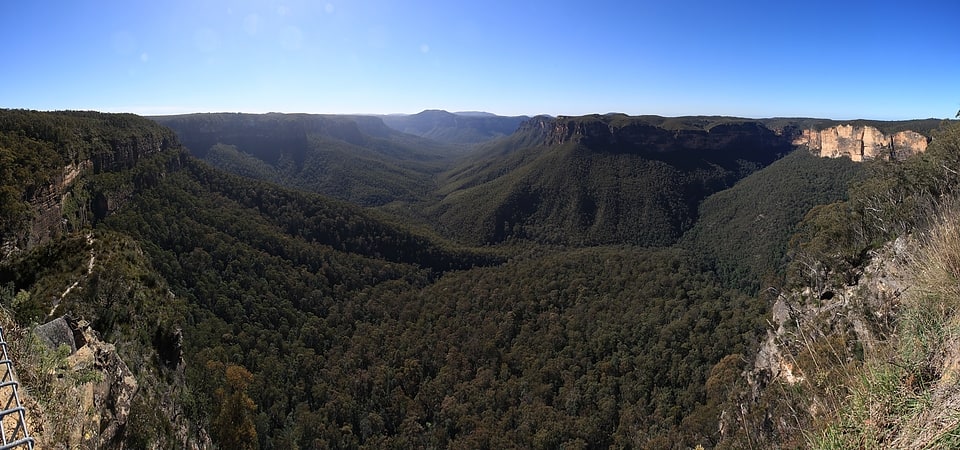
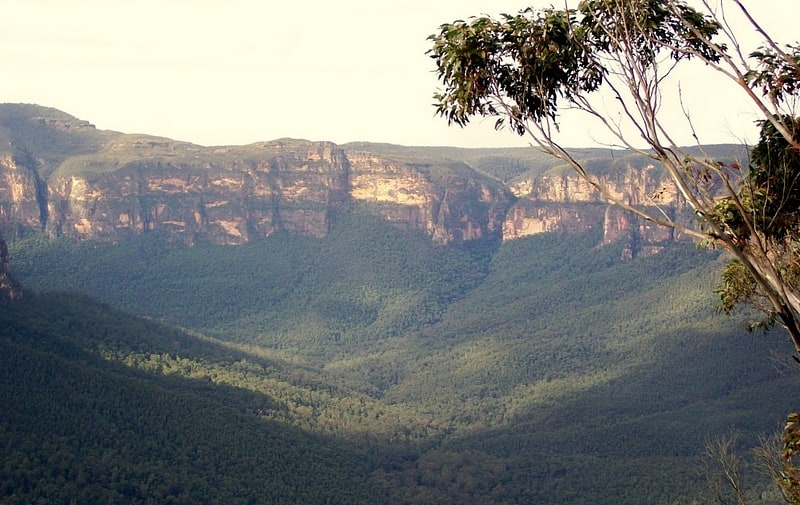
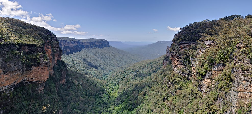
Jamison Valley

The Jamison Valley forms part of the Coxs River canyon system in the Blue Mountains of New South Wales, Australia. It is situated approximately 100 kilometres west of Sydney, capital of New South Wales, and a few kilometres south of Katoomba, the main town in the Blue Mountains.[8]
Narrow Neck Plateau
The Narrow Neck Plateau, an eroded remnant of a sandstone layer situated at an elevation of 1,000 metres above sea level that is part of the Blue Mountains Range which is a spur line off the Great Dividing Range, is situated immediately south-west of Katoomba in New South Wales, Australia, located within the Blue Mountains National Park. The neck separates the Jamison Valley from the Megalong Valley.[9]
Grose Valley
The Grose Valley is a rugged valley in the Blue Mountains, New South Wales, Australia. It has been formed by the Grose River, the headwaters of which are in the Mount Victoria area. The valley is located between the Great Western Highway and Bells Line of Road, the two major routes across the Blue Mountains. The majority of the valley falls within the Blue Mountains National Park.[10]
Kings Tableland
Plateau in Australia. The Kings Tableland is a plateau, located in the Blue Mountains in Wollondilly Shire, New South Wales, Australia. The ridge is an eroded remnant of a sandstone layer that is approximately 1,000 metres AMSL, situated immediately south of Wentworth Falls. The Tableland is the major southerly spur of the main spine of the Blue Mountains Range and forms the beginning of the Southern Escarpment, an unbroken series of tall sandstone cliffs which fringes the Jamison, Megalong, Kanimbla and Hartley Valleys.
Situated to the west of the locality of Blue Labyrinth, Kings Tableland extends from Bodington Hill south to McMahons Lookout, with views over Lake Burragorang, and further about 4.8 kilometres (3.0 mi). The plateau was named by Governor Macquarie after King George III.
It extends southwards from Wentworth Falls and is the eastern boundary of the Jamison Valley. There are also views from several points along the ridge, accessed via paths breaking off the main fire trail. The ridgetop fire trail itself is accessible to 4WD and AWD vehicles in good weather conditions, and is used as a mountain biking (MTB) route.
Along the way is Battleship Tops, an aboriginal meeting place where ochre paintings could be seen, though these have been damaged by vandalism. A 2007 survey of the area found four rock shelters with paintings and several other sites.[11]