Discover 11 hidden attractions, cool sights, and unusual things to do in Baranof Island (United States). Don't miss out on these must-see attractions: Medvejie Lake, Mount Verstovia, and Blue Lake. Also, be sure to include Baranof Lake in your itinerary.
Below, you can find the list of the most amazing places you should visit in Baranof Island (Alaska).
Table of Contents
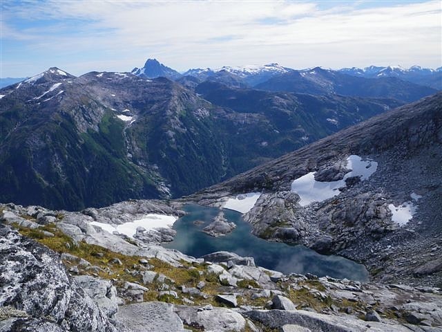
Medvejie Lake
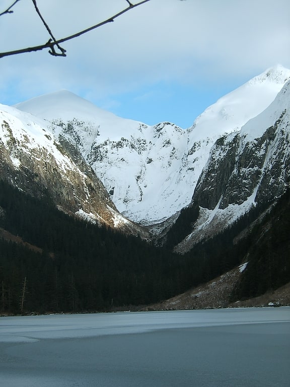
Lake in Alaska. Medvejie Lake is a long, narrow, snow-fed lake on Baranof Island just south of Sitka, Alaska in the Alaskan Panhandle, which drains into Silver Bay, eight miles southeast of Sitka, on west coast of Baranof Island, Alexander Archipelago.[1]
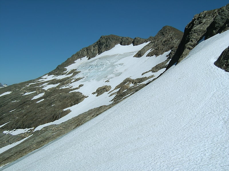
Mount Verstovia

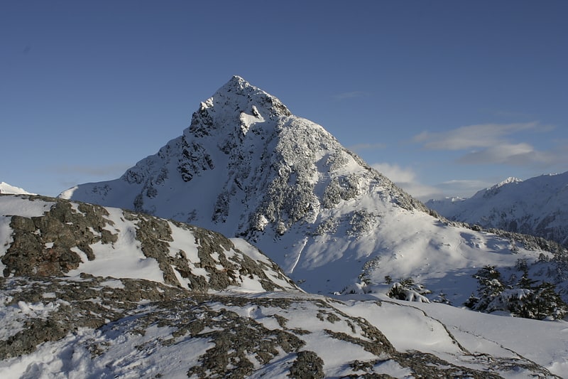
Summit in Alaska. The prominent peak of Mount Verstovia is located just 2.6 miles east of the center of Sitka, Alaska, on Baranof Island, Alexander Archipelago. The 3,354-foot summit rises steeply from the nearby Pacific Ocean, with its lower flanks cloaked in temperate old growth rain forests and its upper regions, above 2,400 feet, being above treeline and providing excellent vistas of Sitka and the surrounding mountain and ocean environments.
This peak was first named "Gora Verstovaya" in 1809 by the navigator Ivan Vasiliev. Gora translates to mount in Russian and verst refers to a unit of measurement equaling 0.6629 miles (or 3,500 feet) which closely resembles the actual height of Mt. Verstovia.
The main summit of Mount Verstovia is called Arrow Head by the people of Sitka, Alaska, because of its resemblance of an arrow head pointed up behind the sub peak.
A significant sub peak of Mount Verstovia lies just 0.5 miles to the west of the main summit. This 2,550 foot "hump" was reported in 1869 by G Davidson, USC&GS, to be named Cross Mountain. After that cross was erected by the Russians the Tlingit gave it their own name of Kanéisti Shaa (Cross Mountain). It is said to have acquired that name as the Russians erected a cross there. This sub peak is now locally referred to as "Picnic Rock" although it bears no name on USGS maps. In hopes of avoiding confusion, modern USGS maps now name an entirely different peak some 8 miles to the southeast as "Cross Mountain".[2]
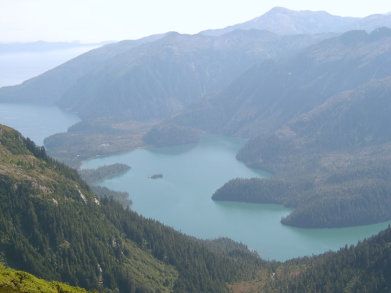
Blue Lake
Reservoir in Alaska. Blue Lake is a 3 miles long reservoir located 6 miles east of the town of Sitka, on the west side of Baranof Island, in the Alexander Archipelago of Southeast Alaska.[3]
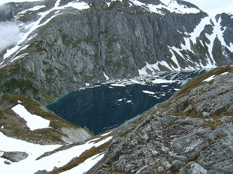
Baranof Lake
Lake in Alaska. Baranof Lake is a glacially-fed, horseshoe-shaped lake on the eastern side of Baranof Island, in Alaska. Baranof Lake borders the community of Baranof Warm Springs and also has a Forest Service cabin on the northwestern end of the lake. Baranof River flows into the lake's western end and exits on the eastern end in rapids and a waterfall.
Baranof Lake was likely named for the community of Baranof Warm Springs.[4]
Indigo Lake
Lake in Alaska. Indigo Lake or simply Indigo is a lake lying ten miles southeast of central Sitka, on the western coast of Baranof Island in the Alexander Archipelago of Alaska.
The name was reported in 1954 by local Sitkan Robert N. DeArmond to the USGS and was so named because its intensely and mysteriously indigo blue color. The lake about eight tenths of a mile across and long (a circular shape) with very steep and cliffed walls.
The southern ridge of Indigo Lake plays an important part in the trail to Peak 5390.[5]
South Baranof Wilderness
The South Baranof Wilderness is a federally designated wilderness area within the Tongass National Forest, located on Baranof Island, Alaska. Covering 319,568 acres south of Sitka, the South Baranof protects glacier-carved fjords, hanging valleys, old-growth temperate rainforests and sheer granite mountains.
The wilderness was created by Congress in 1980 as part of the Alaska National Interest Lands Conservation Act.[6]
Camp Lake
Lake in Alaska. Camp Lake is a small snow-melt and rain-fed lake that feeds into the Blue Lake watershed on Baranof Island in the Alexander Archipelago in the Alaskan Panhandle. Camp Lake is a popular destination for the first night on the Baranof Cross-Island Trail due to its surrounding alpine meadow and the beautifully clear nature of the lake. Camp Lake sits between Bear Mountain and Mount Bassie and atop a small headwall on the Medvejie Lake valley, although the lake drains into the Blue Lake watershed. Departing from the Medvejie Hatchery, the trail to Camp Lake spans approximately 3.33 miles but requires considerable effort due to the difficult terrain and, in certain sections, dense vegetation.
Camp Lake is not named on USGS maps. In his book on hunting, Les Yaw names the lake "Camper's Lake".[7]
Old Sitka Site
State park in Sitka, Alaska. The Redoubt St. Archangel Michael Site, also known as the Old Sitka Site and now in Old Sitka State Historical Park, is a National Historic Landmark near Sitka, Alaska. Now of archaeological interest, the site, about 7 miles north of Sitka at the end of Halibut Point Road, was the site of the early Russian-American Company settlement known as Redoubt St. Archangel Michael. It was the first non-Native settlement on Baranof Island. It was declared a National Historic Landmark in 1962, and was made a state park in 1966.[8]
Mount Arrowhead
Summit in Alaska. The prominent peak of Mount Verstovia is located just 2.6 miles east of the center of Sitka, Alaska, on Baranof Island, Alexander Archipelago. The 3,354-foot summit rises steeply from the nearby Pacific Ocean, with its lower flanks cloaked in temperate old growth rain forests and its upper regions, above 2,400 feet, being above treeline and providing excellent vistas of Sitka and the surrounding mountain and ocean environments.
This peak was first named "Gora Verstovaya" in 1809 by the navigator Ivan Vasiliev. Gora translates to mount in Russian and verst refers to a unit of measurement equaling 0.6629 miles (or 3,500 feet) which closely resembles the actual height of Mt. Verstovia.
The main summit of Mount Verstovia is called Arrow Head by the people of Sitka, Alaska, because of its resemblance of an arrow head pointed up behind the sub peak.
A significant sub peak of Mount Verstovia lies just 0.5 miles to the west of the main summit. This 2,550 foot "hump" was reported in 1869 by G Davidson, USC&GS, to be named Cross Mountain. After that cross was erected by the Russians the Tlingit gave it their own name of Kanéisti Shaa (Cross Mountain). It is said to have acquired that name as the Russians erected a cross there. This sub peak is now locally referred to as "Picnic Rock" although it bears no name on USGS maps. In hopes of avoiding confusion, modern USGS maps now name an entirely different peak some 8 miles to the southeast as "Cross Mountain".[9]
Mount Bassie
Mountain in Alaska. Mount Bassie is a large mountain in the center of Baranof Island, Alaska, United States, within the City and Borough of Sitka.
Mount Bassie is a massive hulk of rock, its footprint covering nearly five square miles. It is bordered by the Blue Lake and Medvejie Lake watersheds and the Baranof River watershed, effectively splitting the island in two (one can see both Chatham Strait and the Pacific Ocean from the peak and its surrounding ridges). Mount Bassie is adjacent to Camp Lake, from which ascents typically originate. It is fairly isolated in terms of sister peaks and has only two modest lower ridges running off the south and north sides of the mountain. The rest of the mountain slopes down steeply into surrounding river valleys. Mount Bassie is rarely summitted, although the western face is frequently traversed on the Baranof Cross-Island Trail.[10]
Gold mining in Alaska
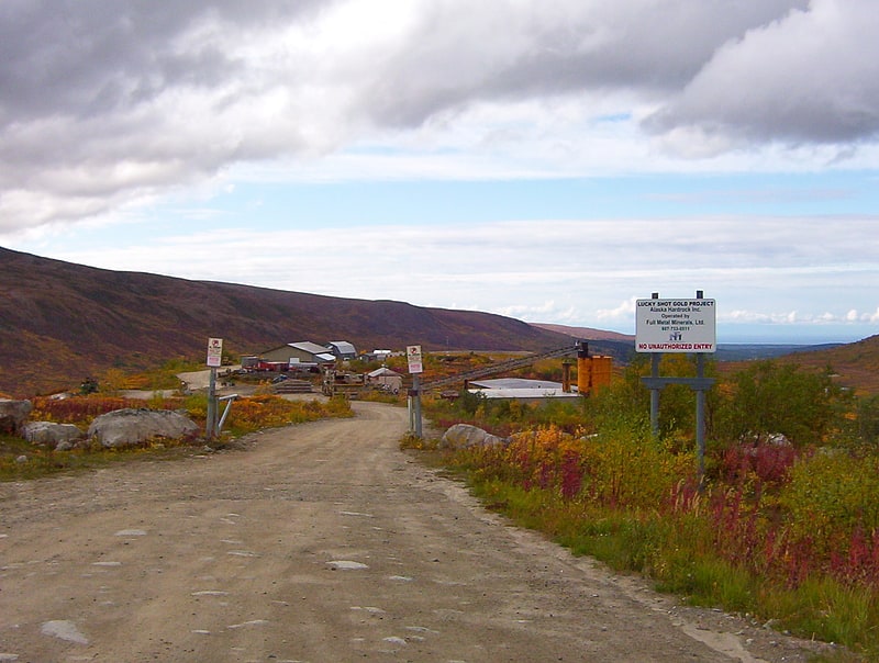
Gold mining in Alaska, a state of the United States, has been a major industry and impetus for exploration and settlement since a few years after the United States acquired the territory in 1867 from the Russian Empire. Russian explorers discovered placer gold in the Kenai River in 1848, but no gold was produced. Gold mining started in 1870 from placers southeast of Juneau, Alaska.
Gold occurs and has been mined throughout Alaska; except in the vast swamps of the Yukon Flats, and along the North Slope between the Brooks Range and the Beaufort Sea. Areas near Fairbanks and Juneau, and Nome have produced most of Alaska's historical output and provide all current gold production as of 2021. Nearly all of the large and many of the small placer-gold mines currently operating in the US are in Alaska. Seven modern large-scale hard-rock mines operated in Alaska as of 2019; five were gold-producing mines. There are also small-scale hard-rock gold-mining operations. In 2019 Alaska produced 539,390 troy ounces, 8.4% of the total national production, second only to Nevada (76%). This total was in steady decline from a peak of 1,022,987 ounces in 2013, which had been the highest since 1906. 2019 production was from five major mines: Fort Knox, Pogo, Kensington, Greens Creek and Dawson.
For 2018, gold worth $888,302,130 accounted for 28% of the mining wealth produced in Alaska. In comparison, zinc and lead mainly from the Red Dog mine, accounted for 66%; silver, mainly from the Greens Creek mine, accounted for 6.6%; and coal accounted for 1.1%. Alaska produced a total of 49.27 million troy ounces of gold from 1880 through the end of 2018.[11]